fbpx

Ketchikan, Alaska RNAV (GPS)-B (PAKT)

Consider flying this approach even in VFR conditions.

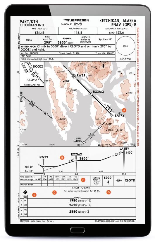
A bucket list trip for many pilots, flying an aircraft up to Alaska can involve some of the most scenic flying in a pilot’s lifetime. For many who are following the coastal route, Ketchikan becomes a first major stopping point for fuel when heading north from the continental U.S. Being next to the ocean, weather conditions may require a pilot to fly an RNAV (GPS) approach. As a potentially unfamiliar mountainous area, flying this approach might be a good idea even in VFR conditions to guarantee a clear shot to the airport

A. Use Feeder Waypoints

Waypoints such as DWARF, GIRTS, and LATRY are good points to consider using when establishing onto this approach. With minimum altitudes depicted from these points to the final approach path, a pilot can be assured they will remain clear of obstacles around the airport. An approach like this might be used even in marginal VFR—or even fully VFR conditions—to help guarantee obstacle clearance.

B. Check Descent Angle

A standard instrument approach will have a 3-degree angle of descent. This has a much steeper one. A note in the table that compares approach speeds in correlation to descent angle and fpm descent required shows a 6.49-degree descent angle. If you are flying an aircraft that approaches at 100 knots, this means you will need a 1,152 fpm descent rate after passing the ROZMO final approach fix to get down to the minimum altitude in time. This is certainly steeper than the typical 700 to 800 fpm descent rate we most often use when flying a nonprecision approach that doesn’t include a glide slope.

C. High Approach Minimums

While there are other approaches at this airport that have straight-in minimums, if a pilot selects this approach, only circling minimums are available. By allowing a descent no lower than 1,888 feet agl, the approach might not be the one to select in low weather conditions. A pilot should use this approach for a descent from the en route environment with a higher layer of clouds and to help sequence the airplane on a path aligned with the airport.

D. Circling-Only Minimums

While the approach path looks to be aligned with a runway, the procedure only offers circling minimums. This approach should help a pilot transition to visually maneuvering for a landing. There is also a note that indicates circling is not authorized northwest of Runway 11/29. The terrain features climb at one point to 3,285 feet—well above the lowest potential circling minimum of 1,980 feet—leaving a pilot below terrain that is close to the airport to the northeast.

E. Faster Approach Speeds?

The lowest minimums on this approach are available for aircraft capable of flying at or below 90 knots for their approach speed. If you are going between 90 and 120 knots on your final approach, it will increase minimums to 2,620 feet, a bump of 640 feet. Don’t cheat on this, because the faster speeds mean you might not clear terrain during a missed approach if you descend too low and need to climb out. The lowest published minimums on this approach may not be applicable for your particular aircraft’s approach speeds.

F. Patience on the Missed

From the airport, a pilot transitions to the CLOYD intersection and then to DOOZI where a 5-nm-leg hold would be entered if needed. The approach plate has the pilot doing this at 5,000 feet msl, and a total distance of 23 nm (16.3 nm beyond CLOYD) is needed to get to DOOZI from the PAKT airport. The goal is to get the aircraft into a location clear of obstacles where a pilot can hold while they decide what to do next.

Login

New to Flying?

Register

Already have an account?