fbpx

Chart Wise: New Orleans VOR DME 36L (KNEW)

A good GPS navigation system would help a lot on this Louisiana approach.

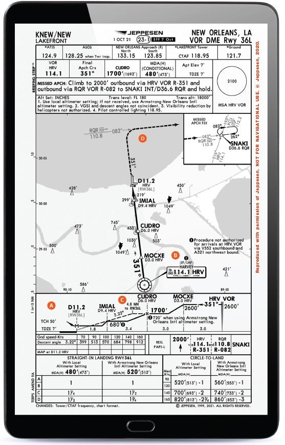
A pilot traveling to New Orleans might choose to avoid the business commercial airport to the west and instead fly into Lakefront Airport (KNEW) to be closer to downtown. Doing so, it might become useful to approach the airport via the VOR DME Runway 36L approach.

For what looks like a pretty straightforward VOR approach at first glance, there is a lot going on here that might trip up a pilot—and using a solid IFR GPS navigator would help significantly.

Featured

While most of us get used to using GPS-based approaches more frequently, we still find use in VOR approaches periodically. In this case, the procedure will get a pilot down to just under 500 feet agl when flying a straight-in approach, so it might be an acceptable option in all but the worst of weather conditions for many.

A) DME Required

On some approaches, DME requirements are set in the notes section. In this example, DME is noted in the header for the approach. This is an indication that it’s required to be able to conduct the approach. A second and third hint on this one would be that there are no times listed for missed approach points and that DME points are noted along the profile view to identify the final approach fix, step-down fixes, and missed approach point. Be ready to use DME from the Harvey (HRV) VOR or a suitable IFR-capable GPS.

B) The Approach

Navigating to a starting point on this approach may not be as clear to many as some approaches. The good news is that finding the “IAF” denotation over the HRV VOR is the key. A pilot could choose to start this approach from the VOR if not being vectored, or if assigned, then proceeding inbound on a 351-degree heading. There is a note at Harvey VOR. If you are using V552 southbound or A321 northwest bound from the low altitude enroute chart, you would not be authorized to start the approach using this VOR. The reasoning for limitations such as these is typically because they would cause a severe turn onto the final approach course that might take a pilot out of a protected area.

C) Stepdowns with DME

After crossing the HRV VOR, a pilot proceeds along the 351-degree radial to 3 miles from the VOR where they can descend from the crossing altitude of 2,600 feet to 1,700 feet, where they will count up to 6 miles and then cross the final approach fix at CUDRO. Another stepdown fix is available at IMIAL after which the pilot counts up to a distance of 11.2 DME from the HRV VOR, where they would go missed without the runway environment in sight. A key point that a pilot should know is whether they are “counting up” from the HRV VOR using traditional VOR DME or “counting down” when the approach is loaded to use an IFR GPS to substitute for DME.

D) Missed Uses Different VOR

New Orleans may have some connection with voodoo, and flying this missed approach might require some IFR magic if you conduct it without a GPS. The missed first takes a pilot straight ahead using the HRV VOR on a 351-degree radial but then requires the intercept of the 082 degree radial from the RQR VOR. That radial intercept isn’t given a DME point that might help a pilot “count up” to when they will be expecting the turn. Once intercepting this radial, the pilot then transitions to using the RQR VOR and flying east on the 082 degree radial until they intercept the 016 degree radial from the HRV VOR again at a waypoint designated SNAKI. This one at least gives us a DME of 36.6, but it’s worth noting that DME is from the RQR VOR, so make sure your readout is coming from that and not the HRV VOR you might have been using as you flew the approach. One more confusing option: You could also identify SNAKI using the Picayune VOR (PCU) 193 radial.


This column first appeared in the January-February 2024/Issue 945 of FLYING’s print edition.

Login

New to Flying?

Register

Already have an account?