fbpx

Chart Wise: Truckee-Tahoe RNAV (GPS)-A

There's a unique way for a pilot to approach this mountain getaway in California.

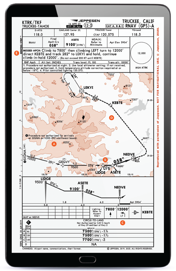
A trip to Lake Tahoe on the Truckee, California, side might find a pilot wanting to visit the Truckee-Tahoe (KTRK) Airport. With a relatively long, 7,001-foot runway, even with the higher field elevation of just under 6,000 feet msl, the airport is an attractive option for many flying into this mountain getaway because of its proximity to Lake Tahoe, area ski resorts, and hiking trails. That’s not to say the approach isn’t without unique considerations that make it worthy of some review.

A) Terrain All Around

The airport elevation of 5,904 feet msl doesn’t sound all that terrible until you look around and see that there are many parts of the terrain that are above 9,000 feet, especially to the west and south. The pilot needs to get established on the approach and then navigate along the course while descending between higher terrain.

Featured

B) Turn to the FAF

Approaches typically keep a pilot flying a straight line from fixes preceding the final approach fix as much as possible, but because of terrain here, that isn’t an option. A pilot would typically navigate using their GPS system to the initial approach fix (IAF) at the SIGNA waypoint and then follow the 091 course to the intermediate fix (IF) at GEGVY. At this point, they turn to follow a 076 course through the LIDGE waypoint and to the final approach fix (FAF) at ASETE. Through this sequence, you descend from minimum altitudes of 10,000 to 9,500 feet msl, then 9,100 feet, which will be achieved before a final descent from the FAF to the missed approach point at NEDVE.

C) Circling Only; Higher Too

This particular approach is an “-A” approach, which indicates that it does not align with a particular runway. Instead, it lines up approximately with the approach end of Runway 11, although not straight with it. As such, only circling minimums are offered, and a pilot will need to stay above 7,500 feet msl (or 7,700 feet if flying a faster approach) until they are in a position to land using normal maneuvers. This is going to require circling at an altitude of 1,596 feet agl (or 1,796 feet for the faster aircraft). For most pilots used to flying traffic patterns at 1,000 feet agl, this circling altitude is higher than they are used to, and extra care in maneuvering is advised.

D) Multisequence Missed with a Speed Limit

If a missed approach is needed, the pilot is going to have to first climb ahead to 7,800 msl before initiating a climbing left turn to 12,000 feet msl and heading to the intermediate fix at KEBTE. While doing this, a notation indicates the pilot must not exceed 200 knots. This is to allow the pilot to climb while not traveling farther laterally in the time toward terrain. After doing this, they then turn and track a 282 course to the LEKYI waypoint, where they would enter the hold as depicted. Going straight to the point where the hold is depicted would not be authorized and, in fact, might cause the pilot to encounter terrain while they were climbing—something that would surely like to be avoided.

E) Not for Nighttime

A specific approach notation states, “Procedure NA at night.” It makes sense, as circling in this terrain without visibility would be a pretty risky endeavor. This approach is best saved for daytime operations.


This column first appeared in the December 2023/Issue 944 of FLYING’s print edition.

Login

New to Flying?

Register

Already have an account?