fbpx

Chart Wise: Finger Lakes RNAV Rwy 1

It's a straightforward T-bar approach to this wine country airport in New York.

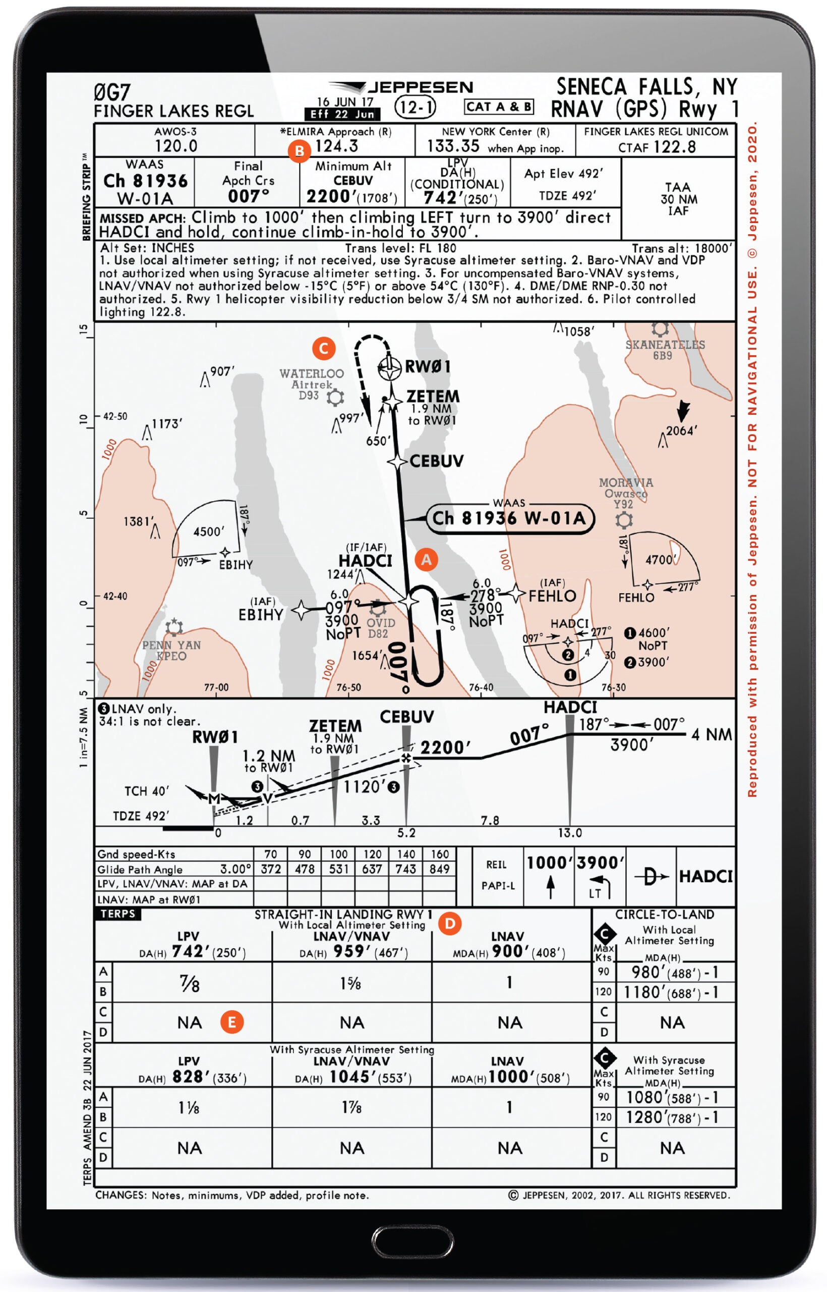
If you are heading up to the Finger Lakes region of New York for some hiking, biking, boating, fishing, skiing—or even just to visit a few vineyards for some wine tasting—you might choose to use the Finger Lakes Regional Airport (0G7) in Seneca Falls to launch your adventures when arriving by air. The RNAV (GPS) Runway 1 is a pretty straightforward T-bar GPS approach you might leverage in IFR conditions to get you to the airport— not unusual as the autumn days cool and fog layers into the lakes.

Featured

A) STANDARD T-BAR

Many GPS approaches are set up in a general “T” configuration, where there are initial approach fixes 90 degrees to the side of the final approach path. This allows pilots to transition onto the approach from multiple directions and then have moderated course changes (in this case, no more than 90 degrees) when they transition from the initial approach fix (IAF) path to an intermediate fix (IF), HADCI in this case, to the final approach path. A pilot could also choose to use HADCI as an IAF if it worked well from their approach direction.

B) THREE APPROACH FREQS? NO TOWER

An uncommon occurrence, the government version of the plate lists three different approach control frequencies. That plate lists frequencies for Syracuse, Rochester, and Elmira Approach. A unicom frequency of 122.8 will also be applicable for any final radio calls in the airport environment since it is not towered. The multiple approach frequencies highlight that a pilot coming from the west/northwest might expect to use Rochester, while a pilot from the southwest to southeast approach direction might expect to use Elmira, and that Syracuse might be used in other areas or if either the Rochester or Elmira frequencies were closed for any reason, such as off hours. This particular airport just happens to sit at the confluence of multiple approach control sectors. A pilot would do well to write down assigned frequencies to make sure they are with the correct assigned controller.

C) MISSED BACK TO HADCI

Many GPS approaches carry on straight ahead for a missed approach to a waypoint—not this one. A pilot who goes missed on this approach will first climb to 1,000 feet msl then turn left and head back to the HADCI waypoint, where a 4 nm hold is depicted while continuing to climb to 3,900 feet msl. The good news is that you are set up for another attempt at the procedure should you choose to do it again.

D) LOCAL WX OR INCREASED MINIMUMS

An AWOS-3 is present at the airport from which a pilot might get current ceilings and visibility but also the local altimeter setting. If you don’t get this and rely on an altimeter setting given by Syracuse Approach, you will need to increase DA altitude minimums by 86 feet and MDA altitude minimums by 100 feet; visibility minimums will also need to increase by one-quarter mile. Not all nontowered airports have weather reporting, but since this one does, getting that local altimeter setting will help a pilot utilize the lowest possible options for the descent.

E) FAST AIRCRAFT NEED NOT APPLY

This approach lists minimums only for aircraft that would fly at speeds in categories A and B. If your aircraft flies the approach at speeds applicable to categories C or D minimums, this isn’t the approach for you. To put numbers to it, if you can slow to 121 knots or lower on the approach, there are minimums you can use. Need to approach faster than 121 knots? It’s time to look for a different approach or even another airport—and Elmira Corning Regional Airport (KELM) to the south just may be a better bet.


This column first appeared in the October 2023/Issue 942 of FLYING’s print edition

Login

New to Flying?

Register

Already have an account?