fbpx

Chart Wise: Mackinac Island VOR/DME-A

Midwest bucket list destination in Michigan offers an approach to a modest runway.

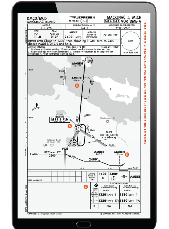
Mackinac Island Airport (KMCD) in Michigan is close to home for me, and it’s one I visit a few times a year. Many pilots who fly in the Midwest have this historic tourist destination on their GA bucket list.

The runway isn’t long—a mere 3,501 feet—so depending on your aircraft performance, it might be shorter than many runways you use regularly. That being said, once you arrive and park, your aircraft may be the last motorized vehicle you use until you leave an island where time appears to have stood still. Enjoy the horse and buggy or bicycle ride into town or to the historic Grand Hotel. But before you get to relax, you just might find yourself in need of an approach to this airport where clouds often develop even in the summer months, thanks to the cool waters of Lakes Michigan and Huron that surround the island.

Featured

During one personal experience on an IFR flight to Mackinac, I found myself needing the VOR/DME-A approach and a circle-to-land because of GPS system testing (signal blocking), thanks to a summer military exercise conducted to the south of the island.

A) IAF AT PELLSTON VOR

A pilot flying this approach might expect to start at the PLN VOR for it. While they might be able to continue from the enroute environment directly inbound as the chart indicates, “NoPT for arrivals on the PLN VORTAC airway radials 131 CW 219” (meaning in general from the south), they should expect a turn in the hold otherwise. Coming from other directions would require the pilot to conduct a course reversal to establish inbound. A hold is depicted to do this.

B) VOR COURSE WIDENS AT DISTANCE

This VOR isn’t on the destination field, but instead at the point where the approach starts. Traveling 14 miles to the missed approach point at MABEH, a pilot should expect this VOR course to widen as they travel farther from the VOR. This might mean they won’t be perfectly aligned with the center of the airport.

C) CIRCLING IS THE ONLY OPTION

With only circling minimums published, and an approach to the runway on a south-to-north line for a runway that is generally east-west, a pilot is going to need to circle to land. Relatively low minimums are present—well below a normal traffic pattern altitude at 579 feet agl. Plus, if you are going to attempt this approach at night, a note indicates it would not be allowed for Runway 8.

D) DME IS THE MISSED

A DME point at MABEH is noted at 14 nm from the PLN VOR for the missed approach point. No other time or cross radials are given on this approach, so make sure you have the DME tuned properly. An IFR GPS can substitute for this normally, but if you were in the scenario I had to use this approach for when GPS was being blocked, the GPS in your aircraft could not substitute for DME. If I didn’t have a separate DME receiver, I wouldn’t have been able to fly this approach because of a lack of ability to identify the missed approach point under those NOTAMed conditions.


This column first appeared in the November 2023/Issue 943 of FLYING’s print edition.

Login

New to Flying?

Register

Already have an account?