fbpx

Chart Wise: Ogden, Utah VOR-A

It's a circling approach to a mountain getaway.

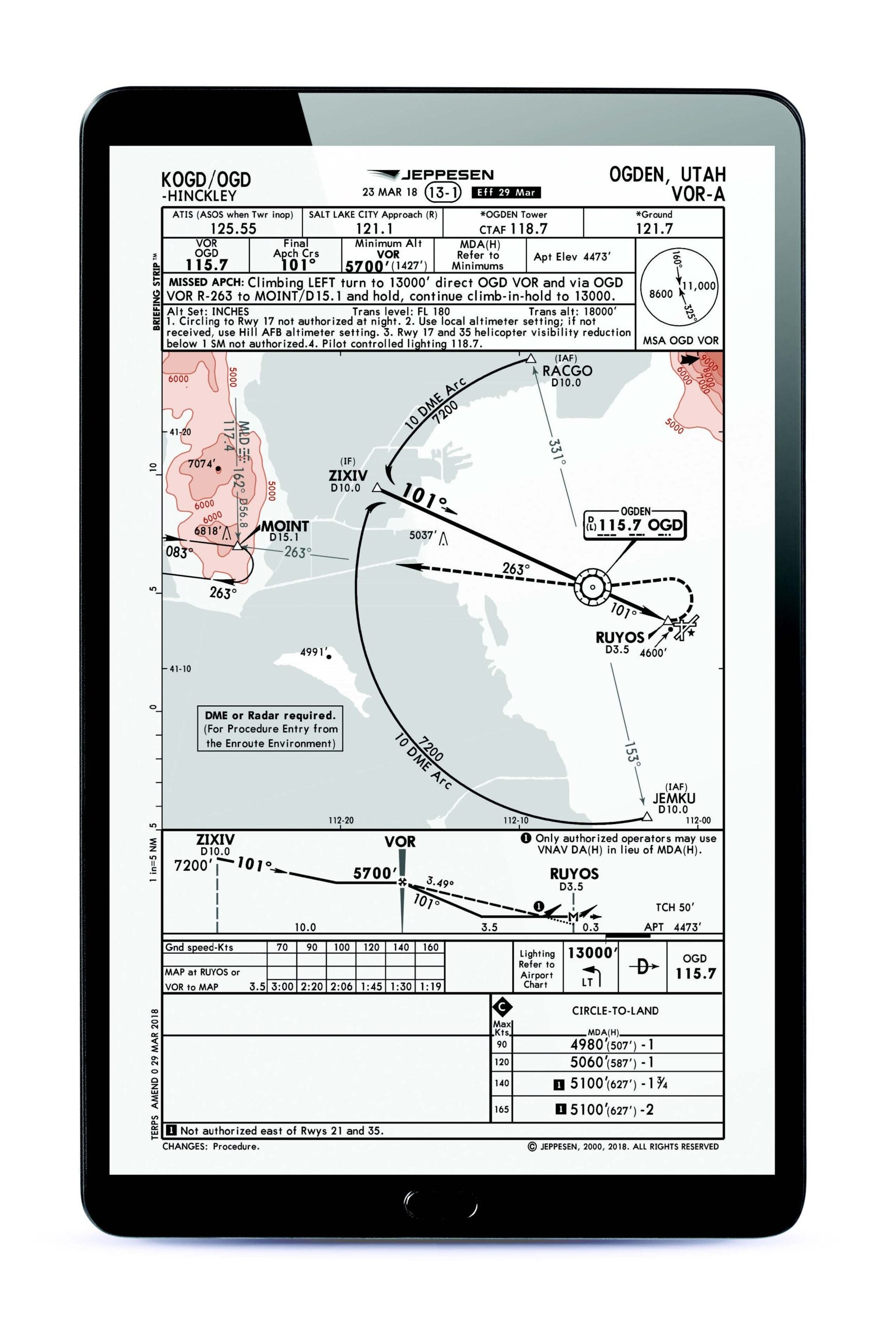
Billed as Utah’s up-and-coming mountain destination perhaps for some skiing in the winter, hiking or mountain biking in warmer seasons, or some of the newer dining options in town, Ogden could be on your fly-to airport list. If it is, the VOR-A might be the approach you use to transition from the en route environment down to the airport, which means you will end up circling to one of the available runways.

Featured

A) NO-STRAIGHT-INS

A VOR-A approach like this indicates that the final approach course does not directly line up with a particular runway. It is designed to approach the airport and, once the runway environment is in sight, the pilot will circle to the runway of their choice. Expect some limitations. Circling to Runway 17 is not authorized at night. Circling east of Runways 21 and 35 is also not authorized for categories C and D aircraft, presumably because of proximity to the terrain to the east and the wider circling path needed for faster aircraft. Remember, a descent below your applicable circling minimum isn’t allowed until you are in a position to make a normal landing on an approach such as this.

B) USE THE ARC

With terrain to the east and west, pilots might take advantage of using the arc from the en route environment (both of these waypoints are on low altitude en route airways) to establish onto a segment of the approach. Both RACGO and JEMKU waypoints are initial approach fixes (IAFs) depicted from which the pilot could use a DME arc to then turn inbound on the 101-degree path to the VOR.

C) WORK THE DESCENTS

A pilot might establish onto a DME arc and descend from the en route environment at a higher altitude to a minimum of 7,200 feet msl along the arc. Once they turn inbound, they can descend when established at 5,700 feet msl until they cross the VOR. After crossing the VOR, a descent to the appropriate circling minimum is allowed. With no glide slope, the pilot must keep track of when and where they descend along the segments of this approach.

D) SHORT DISTANCE: FAF TO THE MAP

It is a mere 3.5 DME from the FAF at the OGD VOR to the missed approach point, and this distance can go by quickly. Timing is an option for determining the missed approach point but so is DME. When you reach the FAF, be ready to quickly find the airport or make a decision to go missed if necessary.

E) CLIMB AND TURN AND KEEP CLIMBING

Going missed on this approach has a pilot turn left to the OGD VORTAC and then following the 263-degree radial to the MOINT intersection, which is 15.1 DME from the OGD VOR. The instructions then note to “continue climb-in-hold to 13,000.” This is a good hint that unless you have some pretty spectacular climb performance from the circle-to-land minimums, if you go missed, you are going to have somewhere around 8,000 vertical feet of climbing to do before you are fully established in the hold. Expect to enter the hold and be climbing until you reach 13,000 feet msl.


This column first appeared in the September 2023/Issue 941 of FLYING’s print edition.

Login

New to Flying?

Register

Already have an account?