fbpx

Chart Wise: Roanoke LDA Y Runway 6

The mountains of western Virginia necessitate an offset approach.

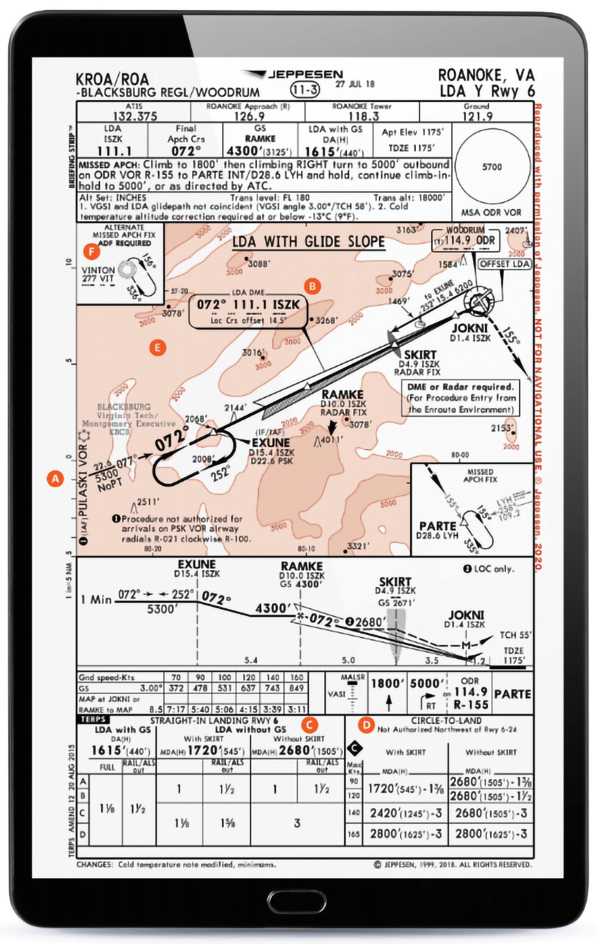
Technically called a localizer-type directional aid (LDA), most of us remember and refer to these types of procedures as “localizer darn angle” approaches. Many of them aim for a single runway but are not directly aligned with it. In this case, a pilot who might be visiting the city nestled in the Blue Ridge Mountains of southwest Virginia might choose to use this less-often-found type of approach when landing Runway 6 via the LDA Y RWY 6.

A) VOR, THEN TURN ONTO THE FINAL PATH

A pilot who chooses to enter this approach from the IAF at the Pulaski (PSK) VOR would then fly outbound on a 077 radial using the PSK VOR as a navigation source for 22.6 nm to the EXUNE waypoint. During this time they would intercept the localizer path using 072 and transition to navigating using the localizer as their inbound navigation source. Make sure your DME source is switched from the PSK VOR to the ISZK localizer to properly count down waypoints along the inbound navigation path.

Featured

B) LOCALIZER OFFSET

A note in the localizer information box, at the bottom, indicates the localizer is offset 14.5 degrees from the runway alignment. Important to note, this means the pilot will have a slight left turn from the approach path of 072 degrees to land on Runway 6 when it becomes visible and they transition from instruments to visual tracking to the runway and their landing.

C) GLIDE SLOPE AVAILABLE—WITH DIFFERENT MINIMUMS

Not all LDA approaches have glide slopes on them, but this one does. So, much like a typical ILS, you will get horizontal and vertical approach path guidance. But if the glide slope happens to be out of service, or your aircraft is unable to use it, the approach minimums are quite different. In a worst-case scenario, if a pilot were unable to identify the SKIRT OM or not have DME/radar options to help apply step down allowances, a pilot would be restricted to a lowest descent of 2,680 feet msl,an extremely high 1,505 feet agl when flying this approach, instead of the lowest possible 1,615 feet msl that puts a pilot down to 440 feet agl. Knowing your aircraft capabilities and how those affect the minimums applicable can make a big difference on this approach.

D) CIRCLING NA NW OF RUNWAY 6/24

Should a pilot need to circle to land, this would not be authorized to the northwest of Runway 6/24. Terrain out to the north and west of the airport is a critical reason for this, and important for the pilot to stay aware of in this area.

E) TERRAIN IN THE AREA

While the touchdown zone elevation (TDZE) on this runway is 1,175 feet, not overly high, there is much higher terrain in the area. Points out to the west of the airport approach and exceed 4,000 feet msl, so this approach will be conducted at altitudes below local area terrain. The MSA (minimum safe altitude) depicted within 25 nm of the Woodrum (ODR) VOR on the field indicates an altitude of 5,700 feet msl would be required. This altitude would give a pilot 1,000 feet of obstacle clearance in that radius and be good to be aware of in the event a pilot experienced an emergency and needed to get to a safe altitude to manage any concerns.

F) IS ADF REQUIRED FOR THE MISSED?

While most pilots transition to using GPS for their missed approach if needed, this follows the ODR VOR 155-degree radial to the PARTE intersection at 28.6 DME, where a hold will begin. But it does transition through the VIT NDB along the way. While the NACO chart shows this NDB on the path, it is actually the VOR radial you would be flying, and it just happens to travel through the VIT NDB. It would not be required to be utilized to fly the standard missed approach path, and it’s not depicted except as an alternate missed approach fix on the Jepp chart. If you have an ADF receiver, use it for a little practice.


This column first appeared in the August 2023/Issue 940 print edition of FLYING.

Login

New to Flying?

Register

Already have an account?