
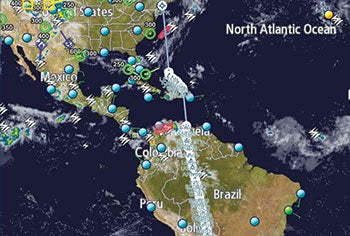


Hovering over a counter in Operations, I tapped at my iPad screen. I was reviewing WSI weather information for our flight south from JFK to Buenos Aires, Argentina. The satellite picture indicated a wispy but clearly defined line of cloud cover that stretched in a curved path from the Florida Keys all the way to Canada’s Newfoundland. The curve extended into an area over the Western Atlantic where our flight would apparently be routed by ATC.
The evil cold front that had slithered its way across the country from the Midwest to the East Coast had shifted its sinister energy out to sea. A red hexagonal shape from within the WSI map image of the cold front highlighted a narrow area of convective activity.