fbpx

NTSB Cites Weather, Terrain as Possible Factors in Denali Accident

Unable to reach the crash site, investigators documented the wreckage with a drone and aerial photography for the preliminary report.

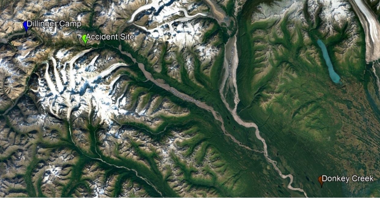
The National Transportation Safety Board (NTSB) has released the preliminary report into a fatal accident earlier this month involving a Piper PA-18-150 (Super Cub) in steep terrain 60 miles northwest of Skwentna, Alaska. Both the pilot and passenger were killed.

On August 6, the pilot and two sheep hunters departed from the Big Lake Airport (PAGQ), Big Lake, Alaska, in a Cessna 206 to scout the Dillinger River area for a possible hunting location and a suitable landing area for the pilot’s PA-18.

The passengers were planning for an 8- to 10-day hunting trip. The morning of the accident, the pilot and the two hunters departed PAGQ in the Cessna 206, subsequently landing at a remote airstrip in an area referred to as Donkey Creek.

The hunters and hunting gear were off-loaded, and the pilot returned to PAGQ to pick up the PA-18 before returning to Donkey Creek to load one of the hunters and his gear for the flight to the hunting location near the Dillinger River. At 11:50 a.m., the pilot told the other hunter he would return in about two hours to transport him to the hunting location.

However, the pilot never returned.

Around 4 p.m., the stranded hunter used a satellite messaging service to contact family members to see if they had heard from the pilot or passenger of an overdue airplane. Over the next several hours, family members and friends of the missing pilot and passenger made several unsuccessful attempts to reach them.

Airplane wreckage in the bottom of a ravine. [Credit: NTSB]

About 9:30 p.m., a FAA alert notice (ALNOT) was issued for the overdue airplane, and the Alaska Air National Guard Rescue Coordination Center (AKRCC) began a search. The efforts were hampered by poor weather in the area.

Four days later, wreckage was located at the bottom of a narrow ravine on the west fork of the Yentna River, also known as Shellabarger Pass, in Denali National Park and Preserve.

Investigators noted that at the time of the accident, preliminary weather information was limited because of a lack of weather reporting facilities in the remote location. However, it was noted that an AIRMET was in effect for occasional mountain obscuration. There were no pilot reports (PIREPs) available within 100 miles of the accident site around the estimated accident time. Also, there are no weather cameras on Shellabarger Pass.

On August 11, the NTSB investigator-in-charge and Denali National Park rangers traveled to the location by helicopter but could not access the wreckage because of the steep and unstable terrain.

Investigators noticed the presence of airplane debris and non-aircraft equipment on the canyon wall about 400 feet above the main wreckage.

The wreckage was photographed by helicopter, and an NTSB drone was deployed to document the accident site.

In the days following the accident, the National Park Service made several attempts to recover the occupants of the aircraft, but the efforts had to be suspended because of hazardous conditions at the site. According to the NPS, any future recovery operations will be evaluated if environmental conditions improve.

Alaska’s nearly 600,000 square miles of terrain includes 14 mountain ranges, and at least 82 percent of the state’s communities are accessible solely by air, according to the FAA. 

Login

New to Flying?

Register

Already have an account?