fbpx

Keyhole: Mapping Brought to Life

The coolest aviation software? It's the virtual world of Keyhole. Just don't tell pilots buddies that it's not intended for pilots.

I recently stumbled across what just might be the coolest pilot software application ever: Keyhole. Well, Keyhole isn’t really intended as pilot software, but pilots are guaranteed to love it.

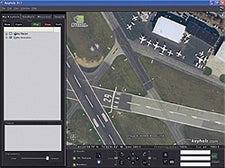
Keyhole-the company was acquired by Google last fall-takes a huge (20 terabytes) database of high-resolution satellite photography-some areas of the country have more detail than others-and puts it into dynamic map form, giving users the ability to zoom into an area to the point that you can see cars on the street, slightly fuzzy cars, but cars nonetheless. You can then use the tilt function to get a 3-D view of things, and you can use on-screen cursor controls to zoom around the area. The sensation is remarkable. It looks just like flying.

Like everybody else, I’m sure, I first zoomed in from outer space to my house. Then I checked out my friends’ houses and the offices of Flying in Manhattan. I could spend all week on this program. The imagery is dramatic and the zoom and tilt functions really bring it to life.

It had already occurred to me that Keyhole would be good for “flying” approaches to unfamiliar airports as a familiarization tool. I decided to check out Austin Bergstrom International Airport in Texas. I entered the address of the airport, hit “enter” and watched the program zoom in at Mach 12 or so. I then found a point a couple of miles off the end of the runway, zoomed down until I was a couple thousand agl-yes, there’s a dynamic altitude readout. I then used the tilt function to make the “approach” look about right, and I used the cursor keys to move ahead. There it was, a flyover of the GA runway at KAUS. You can see runway markings, buildings, even airplanes on the ramp, as well as the surrounding terrain.

You can also fly cross-country if you want. Fly the Missouri River at treetop level, like a latter day Lewis or Clark in a Cub, or tour the Grand Canyon with no flight restrictions. Keyhole would be a great tool, for example, for giving student pilots an idea of what the trip from one spot to another might be. It would even be great for teaching students how to recognize various landmarks along the way.

Of course, the program isn’t for navigation in any way. The images are photographs, and some are older than others; Keyhole says that most images are only a few months old, though others can be as much as a few years old. But as an educational or familiarization tool, it could be tremendously useful.

There’s also an emerging user community that posts favorite spots, including ones of interest to pilots.

A subscription to Keyhole 2 LT, for personal use, costs $29.95 a year. The more capable Keyhole 2 Pro, which can accept an optional module ($299) that allows users to create “flyover” movies, goes for $599 a year. You can try Keyhole free for seven days, which the company suggests that you do before buying a subscription. To get lots more information, including important hardware requirements, visit www.keyhole.com.

Login

New to Flying?

Register

Already have an account?