It is unlikely that inhabitants of any part of the country other than the Northeast really identify with the term “nor’easter.” For those familiar, the word sends shivers. The wind whips out of the northeast in New England when a low parks itself off the coast and blows back cold, wet weather from over the Atlantic. The combination of rain, raw temperatures and wind makes for a special brew. Because the temperatures on the ground and in the air are often oscillating about the freezing point, it is hard to predict whether the weather will be snow, rain, sleet, ice, freezing rain or freezing fog. Local inhabitants tend to stay indoors.
Aviators, however, must deal with weather, and for us a nor’easter is a special delight. It was with this in mind that I sat down at the computer to plan a flight from Lebanon, New Hampshire, to Tampa, Florida, early one October morning. As the screen defaulted to cnn.com, I noted a story about snow in Connecticut and rain in Maine. Looking out the window at dark and ominous overcast skies, I could see the wind shred the last of the fall foliage from the trees. I turned to fltplan.com.
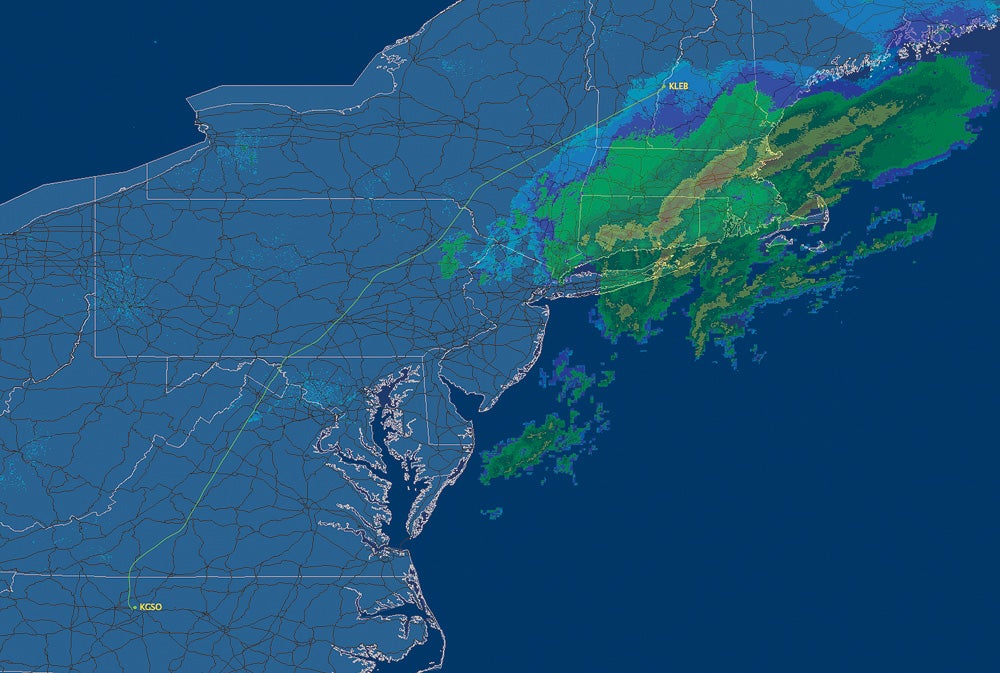
I entered the customary route for our Cheyenne: Hampton on the east end of Long Island, Snow Hill, Norfolk, then to Wilmington, North Carolina, where we usually get fuel. Though I had anticipated that there might be some help from winds out of the northeast at altitude (the heading from LEB to Tampa is about 219 degrees), the computer warned that the flight would take three hours and 54 minutes at FL 240. And this was just the fuel stop. All told, the trip would take six hours and 33 minutes. It seemed the jet stream was careening straight up the East Coast and right up our nose. To add to the excitement, a quick look at www.duats.com proved additionally worrisome, as thunderstorms, turbulence, icing and mountain obscuration were forecasted over almost all of the route. Radar showed precipitation just south of our departure, a snow/ice mix. Ugh.
It is usually impossible to take a western route across Vermont to Albany and then down the west side of the 30 million-plus people who live in the New York-Philadelphia, Baltimore-Washington axis at a reasonable altitude for a turboprop. The reason is obvious; departures and arrivals into these airports are regularly traversing that airspace in the teens and low 20s. Most turboprop operators keep things at least above FL 200 to conserve fuel. Our airplane burns almost 30 percent more gas at 12,000 feet than it does at FL 240. But today I was going to have to chance the westerly route just to stay out of the slop.
Chastened by the headwinds on the flight plan described above as averaging 62 knots at FL 240, I put in FL 220 as the altitude and a route over ALB to Martinsburg to Lynchburg to Greensboro, North Carolina (for fuel) and hit the “press here when done” button.
To my amazement, the calculation for this trip (only 69 nautical miles shorter than the Wilmington plan) was an hour and 12 minutes faster! A tailwind component of one knot was predicted, a swing of 63 knots. How could this be? I went to adds.aviationweather.noaa.gov and pulled up the winds aloft at FL 240. There was the answer: The jet stream screamed out of the west until it got to Cleveland then made an abrupt right-hand turn, dove to Panama City, Florida, then reversed course and powered up the East Coast where it set about pushing that huge low up into the Maritime Provinces. In the cul-de-sac was our westerly route over Albany and Martinsburg, almost an “eye” of the storm. OK, I’ll take it.
Like it often does, a long flight can re-create life in some interesting ways. Hope and disappointment, exhilaration and fear can all present themselves in a few hours while traversing 1,100 nautical miles. A few degrees difference in heading can make for big changes in flights and in life. This day did not make an exception.
We start out direct to Albany at FL 200. We’re in the cloud and it is definitely bumpy. My wife, Cathy, traditionally sits in the cabin facing rearwards, connected to me by those glorious Bose headsets, and I am soon very aware of her apprehension about the turbulence. Of course, it is worse when you can’t see anything. I ask for FL 180, and I can tell she feels guilty about affecting my decisions, but I am committed to the best ride possible; I want her to like the airplane and what it does for us.
The new altitude is perfect. We’re in the clear and it is clear below. The chop abates as Albany slides to our left and we head for Lake Henry. Our ground speeds match those predicted by the flight plan, a copy of which I have tucked into the copilot’s seat rest. I usually record the waypoints and compare predicted to actual times and fuel burns, just as I learned from Les Abend.
Over Lake Henry comes the instruction from New York Center to descend to 16,000. I plead for FL 200, or 220, or 240, but to no avail. Newark arrivals and departures preclude it. I comply and am rewarded with a ground speed of 252 knots, unheard of for us on this heading. The frequency changes are coming quickly now; we’re traversing several sectors and meeting several new voices. Soon we’re turned over to Washington Center. The next controller wants us at 14,000. I balk, I plead, I point out the fuel consequences. No go.
I have whined about altitudes before. In the Northeast, it is just plain busy, so room for a slow-moving turboprop simply isn’t in the cards at the flight levels. Of course, since this is the fastest airplane I’ve ever owned, I bristle at the term “slow moving,” but as far as the centers are concerned, those are the facts. Operators of older, slower-moving jets have told me the same thing affects them, only more so, especially in the Northeast. Held down low, old Citations burn fuel at an astounding rate, and an unfortunate altitude assignment can make a fuel stop necessary on westbound trips, even if the manual says the trip should be easily accomplished. Make no mistake, I’d love to be in that Citation, but as it is, our fuel burn at 14,000 is 108 pounds an hour more than at 220, our originally planned altitude. It is clear now, though, and we’re making good time, so Greensboro should be easy and quick. I resolve to keep my mouth shut.
Then it gets interesting. We’re now cleared to Carmel, J75 Gordonsville, Lynchburg, Henby2 arrival. Next controller: now cleared to Delancy, then Lake Henry, Vector 106 to Selingsgrove, V31 to Harrisburg, V377 Hagerstown, V501 Martinsburg, V143 Lynchburg, Henby2 arrival. And then, and then, descend to 11,000 feet! The controller’s voice exudes a simple fact: This is nonnegotiable. I sulk for a minute before remembering advice from my friend, Bill Wyman, a fellow Cheyenne owner based in Lebanon, New Hampshire. He’s often told me of the wisdom of going VFR when traversing New York City. I defiantly ask/tell Washington, “We’ll cancel, climb to 16,500 feet.”
The controller is cool (definitely not warm) about this rebellion. She gives us a new frequency with a definite air of “see you later” to her voice. I am wracked with guilt. I am bucking the system. I go everywhere IFR. Will they be mad? If Greensboro is IFR, can I refile or catch back up with my original clearance?
Sixteen-five is beautiful; disappointment turns to triumph. Potomac approach and Washington centers are friendly. I feel relieved. I see one airplane, which traverses left to right 500 feet below and about a mile in front. I hear about two others, see them on the Sky Watch, but don’t “see” see them. The air is smooth. Except for the haunting feeling that I might be in trouble, all is well. We’re still doing more than 250 knots. Greensboro has overcast skies, though.
North of Lynchburg, I call Washington Center with a request. They couldn’t be nicer. “Is this an air file, or are you on an IFR flight plan?” I admit to having abandoned the IFR system. They are forgiving. Soon, we’re on the Henby2 arrival.
After refueling at Greensboro, our luck prevails and persists. The route from Wilmington to Tampa featured a headwind component of 34 knots at 220, but our route from Greensboro has only an 11-knot penalty. All told, we burned 2,477 pounds of jet-A for the entire trip. Fltplan.com predicted 2,475 pounds — a staggering miscalculation of two pounds. The trip took 4.8 flight hours, exactly as predicted. On the other hand, the route via Wilmington (only 24 nautical miles longer) was predicted to take 6.2 hours and burn 2,842 pounds, a difference of 365 pounds (55 gallons) and 1.4 hours.
I called Washington Center a few days later and asked supervisor Curtis Johnson if there was a preferred route for ancient turboprops that might represent more responsible citizenry. He was gracious and recommended direct Westminster, Gordonsville, then Lynchburg at 220. “I’ll try it,” I said with thanks.
When I told Mac McClellan about the astounding time and fuel savings that came our way, he said, “We used to call that ‘flying the isobars.'” Whatever it’s called, I find it amazing what a slight adjustment in course can do for you in the air and in life.