fbpx

NTSB Preliminary Report on Kentucky Fatal Crash Released

The agency says the ill-fated aircraft flew into a thunderstorm.

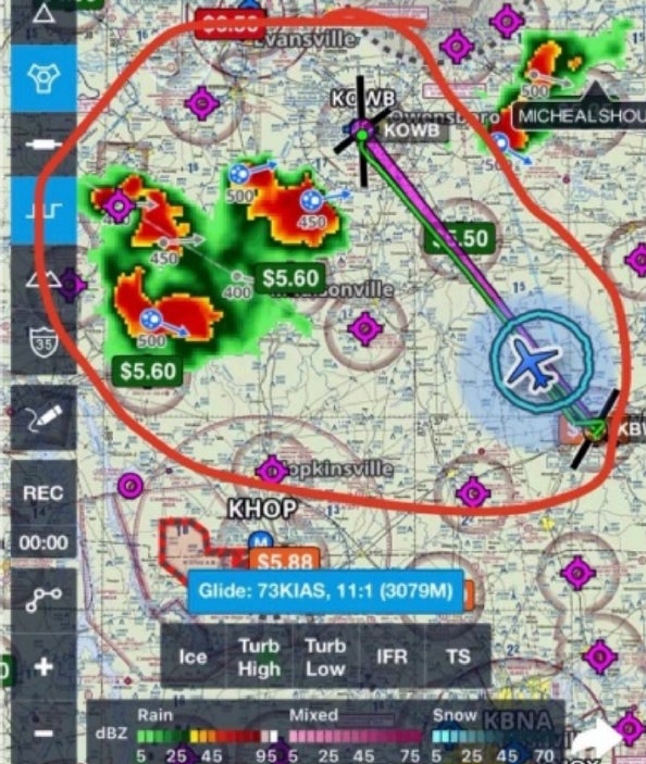
The National Transportation Safety Board (NTSB) has released its preliminary findings on the fatal crash of a Piper PA-28-161 near Whitesville, Kentucky, in September involving a flight instructor and private pilot candidate on a night flight.

According to the report, the pair flew into a thunderstorm. The event has received national attention because the CFI, Timothy McKellar Jr., 22, made several social media posts during the flight that included demeaning comments about the learner, Connor Quisenberry, 18. McKellar also posted an image of approaching thunderstorms along the route of flight. McKellar acknowledged the storms and the flight continued.

The Timeline

On September 27, McKellar and Quisenberry were attempting a night cross-country flight fromOwensboro/Daviess County Regional Airport (KOWB) to Bowling Green-Warren County Regional Airport (KBWG) in Kentucky on a VFR flight plan. The aircraft, a Piper Warrior, belonged to Eagle Flight Academy in Owensboro. According to social media accounts, McKellar completed his solo at the school in 2020, then finished his training at ATP. McKellar’s Facebook profile lists him as a flight instructor employed at ATP. McKellar had a significant social media presence, and often the posts were about flying.

The NTSB notes that, according to the operator of the aircraft and Quisenberry’s regular instructor, this was the first time he had flown with McKellar. In his Snapchat, McKellar remarks “me and this student should not get along if he was my full-time student. I’ve seen faster at the Special Olympics,” then the camera angle is reversed to show Quisenberry, flashlight in hand, performing what appears to be the preflight inspection of the Warrior. The time stamp of the Snapchat shows 8:39 p.m. as McKellar is heard saying, “C’mon.” He posts that the pair have a three-hour flight ahead. McKellar is eager to get the three-hour flight completed because he has to be up at 4:30 a.m. the next day.

According to the NTSB, automatic dependent surveillance-broadcast (ADS-B) data shows the airplane took off from KBWG around 21:55 local time, climbed to an altitude of 4,500 feet msl, and proceeded on a northwesterly course toward KOWB, on a VFR flight plan. According to SkyVector, the distance between the two airports is 58.6 nm. McKellar posted video of the night takeoff and a portion of the in-flight cruise.

McKellar refers to Quisenberry as “Forrest Gump” and posts that he is “just giving it to him straight up,” to which Quisenberry allegedly replies to the criticism by saying, “I don’t mind you being hard on me. I know I need it.” 

The Weather

METARs from the area at the time of the flight show severe weather with lightning in all quadrants. Additionally, the TAFs from earlier in the day indicate the possibility of convective weather.

At 22:15, approximately one hour after takeoff, McKellar posted an annotated weather image from a mobile-device-based aviation navigation tool. The image shows the airplane’s  position northwest of Bowling Green, Kentucky, along with the planned route of flight to KOWB. Weather radar imagery was also displayed in the image, which had been annotated with a circle around the flight track and nearby weather radar returns and a comment from McKellar about the storms approaching like “angry hornets.”

A screen grab of the post is included in the NTSB report, with attention called to the location of the approaching storms, airplane’s position (blue airplane icon), the planned route of flight (magenta line), and the depicted weather radar imagery with the storms circled in red.

The report notes the pilot contacted ATC at 22:44, and the controller advised the flight of heavy to extreme precipitation at the airplane’s 9 o’clock position, roughly northwest of the planned route. ADS-B data showed that the airplane continued its course, and about two minutes later, McKellar requested an “instrument flight rules clearance.”

The controller issued the clearance and assigned a turn to the east to get out of the weather.

McKellar advised ATC that the airplane was “getting blown around like crazy.” The airplane’s flight track showed a turn to the northwest, followed by a right circling turn. The controller reiterated the heading of 090 degrees. McKellar replied that they were in “pretty extreme turbulence.”

The flight track showed a continuing descending turn to the right. There were no further communications. The last ADS-B position was recorded at 22:49 at an altitude of 2,200 feet. The wreckage, described by the NTSB as a “debris field,” was found spread over 25 acres in a hilly, densely wooded area.

The Wreckage

The NTSB noted that all major components of the airplane, with the exception of the left portion of the stabilator, were located in the debris field.

The aircraft had been torn in half with the forward fuselage, including the cockpit, engine, and right wing located together in the most westerly portion of the debris field. The left wing was located 800 feet away.

The empennage with vertical stabilizer intact was located over a ridge about 200 feet north of the forward fuselage. The rudder was torn diagonally from top to bottom, with the lower portion remaining attached to the vertical stabilizer and the upper portion separated and located near the empennage in the debris field.

The stabilator was torn chordwise just outboard of the hinges, with the right side located 1,500 feet away from the fuselage. The wreckage was recovered and sent to a salvage facility for further examination. The engine displayed impact damage, but the NTSB did not uncover any preaccident anomalies or malfunctions that would have precluded normal operation.

The final report will be issued in a few months after the investigation is completed.

Login

New to Flying?

Register

Already have an account?