Weather Check: How To Plan Your Route Around Severe Weather
Here’s how to keep track of a storm’s movement and its impact on airport operations with a few keystrokes.

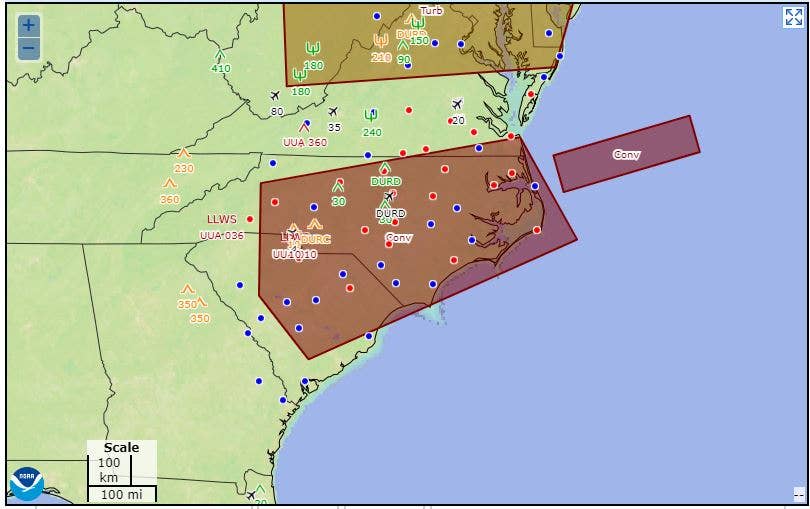
If you are trying to determine the path of a storm, the Aviation Weather Center is a helpful resource. [Courtesy: National Weather Service]
"The airports are closed in South Carolina." This text message got my attention Friday morning. I have been watching Hurricane Ian's path of destruction with a keen eye to its impact on aviation, as I have several airport “sons and daughters” who live and work on the East Coast in areas prone to hurricanes.
When there is a hurricane or severe weather of any sort, aviation weather websites get a work out.
If you are watching the weather, trying to determine the path of the storm, this national weather report, which can be accessed in just a few keystrokes, may be a helpful resource.
How To Get It
- The National Oceanic Atmospheric Administration (NOAA) provides an interactive weather map on its Aviation Weather Center, which may be found here.
Unlike other aviation weather sites, you do not need an account or a password to access this information. It is an excellent supplemental weather tool for pilots, and a valuable site for anyone who wants to check the weather on a global level.
- Under “Aviation Weather Overview” at the top of the page, click on TAFs (terminal area forecasts). Move down the screen to the line that states: "Manually Select TAF Data.” In this box type @ and then the two letter postal code for the state you are looking for. For example, if you want to see what Hurricane Ian is doing to South Carolina, type: “@SC.”
- Select the “Include METAR” box, then click on “Get TAF data” and voila! You have the information for all the airports in that state that have reporting weather.
Raw or Decoded
Pilots are required to learn how to read the weather reports in raw format. It’s how the reports appear on knowledge exams. Using the “Decode” function just makes it easier to understand them, if you are not familiar with the FAA's acronyms.
If you have a copy of the FAR/AIM, you will find Chapter 7 of the AIM has a page I love to call “The Secret Decoder Ring,” because it translates the abbreviations that sometimes don't make much sense—seriously, who came up with BR (“baby rain”) for mist? (Actually, it is an abbreviation for the French word for mist, brume.)
If you decide to go the raw-data route, remember the reports begin with the airport identifier—and you may have to look those up. For example, KACE is Columbia Metro Airport in South Carolina.
In the decoded format, the name and location of the airport are included.
Next, the date and time of report issuance (and in the case of a TAF, when the report is valid), followed by the direction the wind is blowing and the velocity. The letter G means “gust” here. If you see PK WND, that is the “peak wind” recorded.
The acronym PRSFR means “pressure falling rapidly,” which typically means a storm is approaching rapidly.
A METAR at an airport is the “what is happening now” part of a weather report. METAR stands for “meteorological aerodrome reports” and usually provides hourly updates of weather within 5 nm/6 sm of an airport.
If the METAR has the acronym SPECI in front of it, that means the weather is changing rapidly and a special report has been issued to reflect that.

Subscribe to Our Newsletter
Get the latest FLYING stories delivered directly to your inbox


