fbpx

Flight-Planning Challenges Come From All Directions

Just when you think you have all the answers…

It’s always a bit iffy planning an IFR trip that will last more than 48 hours or so. You can make educated guesses on what the weather will be in four or five days (I check the forecasts on Yahoo), but anything beyond the NOAA’s ADDS prog charts (click here) is getting into increasingly uncertain territory. Of course, your airplane’s weather capability has a lot to do with how much this flexibility, or lack thereof, enters into your planning. For example, flight into known ice (FIKI) capability adds a lot of utility, especially this time of year. And even for a non-advanced technology aircraft like mine, a portable GPS with XM Weather is a huge help.

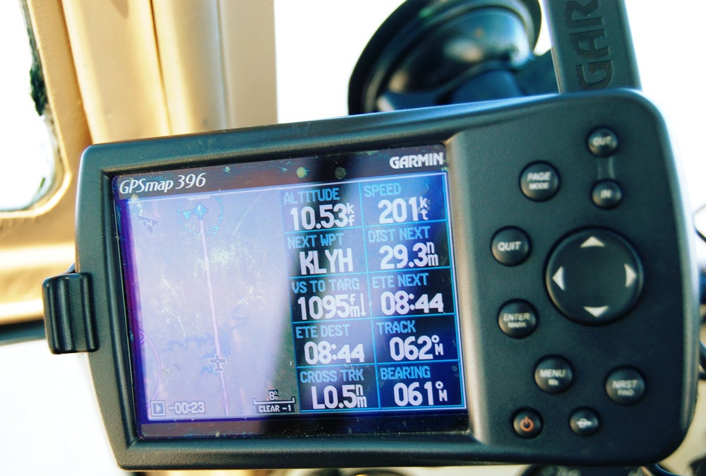
Still, I made a point each evening during last week’s National Business Aviation Association Convention in Atlanta to check the long-range forecasts for my planned return trip to New Jersey on Thursday. Everything looked good. High pressure was moving in, and Fltplan.com promised strong tailwinds, especially for the latter portions of the flight (only fair, given the headwinds on the way down). When I left DeKalb Peachtree Airport about noon, I was looking forward to a relaxed flight home at 7,000 feet with strong groundspeeds. Well, I suppose one out or two ain’t bad.

At some point my clearance was revised to dogleg to an intersection west of my planned course. No problem, I thought, until a few minutes later when the controller advised of a sigmet for severe turbulence below 12,000 feet, first reported by a Beech Sierra southwest of Ashville, North Carolina. The “winds aloft” page of XM Weather showed velocities at 40+ knots, even as low as 3,000 feet. My course was well east of that area, but the new route had me hugging a line parallel to the eastern edge of the steep terrain, and my guess was that the turbulence came from those spanking low-level westerly winds bubbling in and around the peaks and valleys to the west. Good guess. The controller regularly asked how my ride was, and I told him there were a few bumps so far, together with some strong up- and downdrafts, but not bad. Another pilot reported moderate turbulence at 9,000 feet.

Though my experience subsequently graduated to moderate bumps, it never got much worse, but I was less than fully relaxed based on the possibilities. An eventual climb to 11,000 feet put me in calm air, and having turned the corner to a more easterly heading, I began to pick up more of the tailwind component. The attached photo shows my 201-knot groundspeed starting the descent to my fuel stop at Lynchburg, Virginia, based on true airspeed of about 155 knots. Nice.

My planned route had been farther east of the hills, but “restrictions” around Charlotte detoured traffic to the west, closer to the bumps. I could have predicted the turbulence based on unusually strong winds down low. And you should always anticipate that ATC needs could reroute even the best laid plans. The difficult part is deciding when the altered state of your flight plan pushes over into unacceptable territory. If I had experienced more significant turbulence, I would have requested a routing farther from the mountains. It occurred to me after the fact that I should have asked sooner for 11,000 feet – but the language of the sigmet (“severe turbulence below 12,000 feet”) and the pilot reporting moderate bumps at 9,000 led me to assume it wouldn’t have helped. In fact, it probably would have, given the reason for the rough air. We all know what they say about “assuming” things, especially when it comes to weather.

Call to action: If you have any tips of your own you’d like to share, or have any questions about flying technique you’d like answered, send me a note at [email protected]. We’d love to hear from you.

Login

New to Flying?

Register

Already have an account?