fbpx

Flying with Datalink Weather

Five key rules for better decision-making.

Here’s an emerging safety story that hasn’t received much attention: 
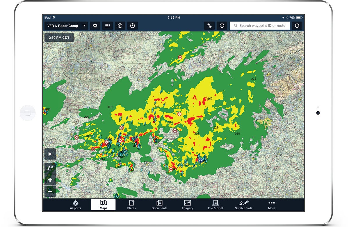
Fatal accidents caused by weather are declining. Nobody should be popping Champagne bottles just yet, but there is enough data to suggest a steady downward trend over the past few years.

What’s the cause of this encouraging course reversal? There are probably many, but the increasing use of datalink weather in the cockpit deserves serious attention. Over the past 15 years, the number of pilots flying with some type of cockpit weather, typically either ADS-B or SiriusXM, has exploded. Portable ADS-B receivers in particular really took off about eight years ago, right around the time the fatal weather accident rate started declining.

Featured

Datalink weather is hardly a miracle cure, as the National Transportation Safety Board and FAA have frequently reminded pilots, but the data certainly is suggestive. The limitation we constantly hear about is that radar is not real-time: Those images are delayed, sometimes by as long as 20 minutes, so they should not be used for close-in storm avoidance. That’s critical to remember during thunderstorm season, but unfortunately, the government drumbeat about this minor limitation has obscured the huge increase in safety that’s possible with this increasingly advanced equipment.

The key word there is possible. Technology is rarely good or bad; it’s merely a tool. To make datalink weather a tool that improves safety, it has to be treated with respect. That means understanding the onboard avionics at a deep level, whether it’s a fully integrated glass cockpit or a portable ADS-B receiver, and making it part of regular recurrent training.

Some real-world weather flying experience is also a must, since the most valuable lessons simply cannot be learned from a textbook. A safe pilot is a weather geek and seeks out opportunities to fly (safely) around dynamic weather conditions. After more than 15 years of making these flights with datalink weather, I’ve changed how I fly cross-country trips, both VFR and IFR. I’ve also developed a few rules for using datalink weather. These aren’t comprehensive, but they help structure my decision-making.

  • Understand the big picture first. A doctor wouldn’t operate on a patient without first understanding the underlying condition, and neither should you read a metar without first considering the overall weather system you are flying in. The first step to safe weather flying starts on the ground, where you develop a theory about what’s going on in the atmosphere. That comes from reviewing the surface analysis, the upper air charts and the forecast discussions. Find out where the lows are, where the fronts are moving and what the winds aloft are doing. This big picture sets the rest of the weather information in context, but it often isn’t given the importance it deserves.

  • Take in enough data, but not too much. Once you have a theory, it’s time to go flying and test that theory by applying real-world data to it. Fortunately, pilots have more data at their fingertips than ever before, so it’s easy to get a detailed picture of the atmosphere around the airplane. Unfortunately, all this data can lead to two mistakes. First, you can’t get so locked into the colorful radar image that you neglect other weather products, such as metars, TAFs, pireps and winds aloft. Radar is fantastic, but it’s only a part of the story.

At the other extreme, it’s easy to get overloaded with data and either forget to fly the airplane or talk yourself in circles without ever making a decision. In particular, be careful about confirmation bias, where you search for any piece of information that confirms what you want to believe. If the weather is below approach minimums at all three airports near your destination, don’t keep searching until you find one good metar. That’s false hope, and it’s dangerous.

It takes practice, but the goal should be to review enough data to have a complete picture of the weather in front of you, but without getting mired in the weeds.

  • Watch the time stamp. Here’s your required warning about the delayed nature of datalink weather. Yes, that radar image could be anywhere from five to 20 minutes old, and a lot can change in a thunderstorm in that time. Carefully watch the time stamp on the app or MFD to make sure you’re getting current weather, and remember that “four-minute-old” radar only means the receiver got that information four minutes ago —it could actually be 10 or 15 minutes since the radar sweep.

That’s why the oft-repeated advice to use datalink weather for strategic avoidance instead of tactical penetration is smart. But there’s more to it than that. If you have a good idea of the big picture, it’s easier to fit changing weather reports into your mental model. Is that storm building rapidly because of a fast-moving cold front or because it’s a hot summer day with unstable air? Another tactic is to animate the weather charts (if possible)to see any trends. Often, the direction and speed of change matter as much as the specific imagery.

  • Make big deviations early on, and change flight plans. The obvious lesson from the previous tip is to avoid severe weather by a wide margin. That requires a change in mindset for many pilots. With datalink weather on board, I spend a lot less time flying up to weather and then asking for “10 degrees left, 20 degrees right” as I pick around cells. Instead, I look at the weather map and change the route of flight 50 miles ahead of time: “Requesting direct Boiler VOR, Victor 97, Chicago Heights to avoid weather.” This might add four minutes to the flight, but it provides a margin of safety, reduces stress, increases passenger comfort and makes life easier for air traffic control (since they can enter it into their computer and pass your new route along to the next sector).

  • Your eyes get a veto. The best weather sensor in any airplane is an observant pilot’s eyes, backed up by datalink weather, not the other way around. In the end, weather avoidance in light airplanes is very much a visual process—even when flying IFR. Instrument pilots can and should fly through clouds, but the best strategy is to stay visual as much as possible and avoid nasty-looking clouds. Never let an iPad screen talk you into flying through weather that your eyes don’t feel comfortable with. I’ve deviated around plenty of buildups that were not showing up on the radar yet simply because they looked ominous to me.

No matter how many hours you’ve logged, weather is a challenge. Unlike instrument approaches, which are static and reward rote practice, weather is constantly changing and demands nuanced decision-making skills. We must approach every flight with a flexible mindset and be disciplined enough to play the hand that Mother Nature deals us. She does not care about the forecast, so the only sure thing is the late Richard Collins’ first rule of weather flying: “What you see is what you get.”

Enjoy Safer Flights with Sentry Plus

The all-new Sentry Plus is loaded with safety features: subscription-free weather, dual band ADS-B traffic, backup attitude, and a carbon monoxide detector.

Login

New to Flying?

Register

Already have an account?