fbpx

I Learned About Flying From That: What Now, Richard?

Smoke obscures one low-time pilot's decisions.

(June 2011) For an 80-something-hour pilot, the Sacramento Valley was like a giant flying playpen for me. The foothills of the Sierra Nevada Mountains border the eastern side while the Coastal Range separates the valley from the Pacific Ocean on the west. The Cascades, including 14,000-foot Mount Shasta, form the northern boundary of the valley.

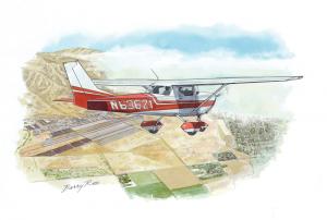
One weekend in October 1978 a friend and I decided to take a Cessna 150 from the local flying club at the Yuba County Airport (MYV), not far from Marysville, California, for a flight to Redding, California. It’s at the northwest end of the valley and is the last stop before heading into the Cascades. We heard there was a decent restaurant on the field. For two young airmen looking for something to do, we needed no other excuse.

There was a flight service station on the field at Marysville in those days. A routine check of the weather confirmed what we could already see, great VFR weather throughout the northern valley, and a forecast to remain that way. As we headed for Redding, we soaked in the beauty of the mountains, the valley and the freedom our “econo-size” chariot gave us. It would take about an hour to make the 93 nm trip.

Even though basic navigation to Redding was as simple as pointing the nose toward Mount Shasta and keeping it in the middle of the valley, I tried to practice good airmanship by using the VOR as well. It wasn’t long before I realized the CDI needle seemed to indicate a one- to two-dot off-course deviation. I suspected the VOR must be out of alignment and couldn’t be trusted for great accuracy. But, under these conditions, it wasn’t really going to be a factor.

The remainder of the trip up was uneventful. While having lunch, we were able to survey a collection of World War II-era bomber aircraft in firefighting colors that was parked around the ramp.

Before departing Redding, I dutifully checked the return weather. A flight service station recording for the northern valley was no surprise. It was the same great weather that we had had on the way up. We launched to the south and, once again, soaked in the beauty that surrounded us.

After about 10 to 15 minutes, I was shocked to see the valley ahead was blanketed with what looked like a solid layer of stratus forming a smooth east-west line across the valley. As I tried to mentally reconcile the weather forecast and reports with what I was seeing out of the window, I came to the conclusion that this must be some sort of local anomaly.

I thought to myself, “The weather in Marysville must be OK. I’ll just fly above this layer for a few miles and then we should be able to land in the clear back at Marysville.” Right. My first impression was that this layer extended as far to the south as I could see. As I began to climb, my fear was confirmed. I’d have to go under it. The top of the layer was around 3,500 msl. There was forward visibility, but it looked reduced all the way to the ground.

I was still in the clear and was just coming abeam Chico, California (CIC), when I thought, “What would Richard Collins and the folks at Flying magazine do?”

I certainly knew that continuing into deteriorating weather resulted in many sad endings. If I’d listened just a little more intently, I probably could have heard the gentle, instructional voices of Richard and his staff whispering, “Turn back to Chico now, ya moron!”

A call to the Marysville’s flight service station made things clear. “Three statute miles visibility in smoke, indefinite ceiling, sky obscured.” No wonder. Smoke. I should have smelled it. The briefer’s parting shot said it all: “If you’re coming in, you’d better hurry up.”

OK, I checked the weather. “Surely that should make Richard a little happy,” I thought. “What next? Seek help.”

As soon as I dialed up Sacramento approach, I could tell I wasn’t the only one caught off guard. The chatter was nonstop. At the first chance to break in, I requested vectors to Yuba County (MYV). I felt apprehensive when the controller issued a squawk code. My “negative transponder” response quickly brought this option to an end. It was common for small aircraft not to have a transponder in the late ’70s.

“So, no vectors. What now, Richard?” Our magnetic course was about 145 degrees. We were inbound on about the 325-degree MYV radial. As long as I was on course, there wouldn’t be a problem, but I was beginning to rely more and more on the VOR, and I knew it could not be trusted.

That was it. I had to do it. Even though we had to be within about 20 to 25 miles of Marysville, I decided to turn back toward CIC. The normally prominent Sutter Buttes that are located 14 miles west of MYV and go up to 2,300 feet msl were nowhere in sight, and we were at 1,500 feet msl. I was not ready to bet our lives on my exact position. I did not want this flight to turn into an Aftermath piece by Peter Garrison.

We turned toward the Chico VOR. This took us away from the buttes. We would be there in about 15 to 20 minutes. Our magnetic course was now about 330 degrees. Initially, I was convinced that, as we headed north, we would eventually pop out and be in the clear. But I realized the wind out of the south was funneling smoke farther up the valley. This meant Chico could now be “smoked in” as well.

Before I had a chance to contact Chico, my friend yelled out (we had no headsets), “There’s an airport!” After consulting the sectional, I determined that we’d reached a private field about 4.4 miles south of Chico called Ranchero CL56.

At that point I decided that “a bird in the hand is worth two in the bush.” We were landing at Ranchero. I maneuvered for downwind while descending to pattern altitude. I set up for a normal approach and landing. Carburetor heat, power back and 10 degrees of flaps abeam the end of the runway. Wait a minute. Something wasn’t right. I wasn’t at 45 degrees to the runway yet and I was losing sight of the field. Turning base. More flaps out. Wow, we were really high. “Get the rest of the flaps out. Still way too high. Try slipping. This is not working. Go around.”

My initial impression was that it was far shorter than the 6,000 feet I was used to at Yuba County. What I didn’t pick up on the sectional was that it was only 2,100 feet.

Unfortunately, I did the second pattern exactly how I did the first, which resulted in another go-round. As we climbed out following the second go-around, it dawned on me. A normal approach and landing technique was not working because these were not normal conditions. I had to adjust my technique to match the conditions.

Since I kept ending up too high, I limited my pattern altitude to 600 feet agl. I reduced power and got 10 degrees of flaps by midfield and began the descent shortly thereafter. I got full flaps in early and used a short-field technique. The landing was uneventful.

When we finally shut down, I looked across the field. I couldn’t believe we’d been flying in this. It looked worse on the ground.

So what did an 80-something-hour pilot learn from this? I realized that passing up decent landing spots with the hope of things improving down the road was a bad choice. Sometimes, the best bet is to cut your losses, land where the landing is good and figure things out once you’re safely on the ground.

Read more “I Learned About Flying From That” columns here.

Add to Google

Login

New to Flying?

Register

Already have an account?