













Take the Tradeoffs

Defining good weather, enough for a visual approach, can be tricky. Use that instrument procedure as a backup, but be sure to adjust for those ever-changing conditions.

Gemini Sparkle

Key Takeaways:

  • Comprehensive pre-flight planning is crucial for IFR flights, involving meticulous attention to fuel, routing around restricted airspace, and preparation for both instrument and visual approaches, especially to unfamiliar airports.
  • Pilots must adapt plans dynamically to evolving weather and operational realities, adjusting routes and fuel stops in real-time to maintain safety and efficiency when conditions deviate from forecasts.
  • Strategic decision-making involves weighing pros and cons of various IFR and VFR techniques, such as utilizing visual approaches under IFR, to ensure a safe and efficient flight across varying weather conditions.
See a mistake? Contact us.

Editor’s note: Observant readers will see that this article type, above, is now called, “IFR Files,” thoughtfully suggested by Ms. Kauh, who began writing these articles about 10 years ago. (Thanks, Elaine.) The change helps eliminate confusion with other article types and is more descriptive.

Filing IFR when it’s clear-and-a-million means less workload, great views and a safe passage to the destination. Sometimes you just luck out; sometimes, you need to route around that good weather. That, plus building a route that’s still IFR-friendly, still takes time to plan. And for unfamiliar airports, be sure you’re up on both instrument and visual approaches. There are multiple options for staying safe, but each one requires weighing a pro against a con. Grab from both IFR and VFR buckets as you need to make things fit together as you transition from one set of weather conditions to another.


Plan, Then Wait

It’s a weekend-duffel-bag trip with your spouse from home in Billings, Montana, to Yankton, South Dakota. With a load of birthday gifts and some hand-you-downs for all the nieces and nephews eagerly awaiting your arrival, you hope to shed about 100 pounds for the return trip. Plus, you could use a few more weeks on your no-dessert diet, but forget about that for a couple days; there’ll be cake. For now, you monitor weather at Yankton for tomorrow’s trip. As you’ve never been flown to KYKN, you’d much prefer to arrive with at least daytime marginal VFR. 

You’re glad to see that VFR weather’s expected in most of South Dakota following a cold front, also bringing moderate to heavy winds and associated turbulence. But with a sturdy low-wing and years flying out of Montana, these won’t exceed your capabilities, so you accept the tradeoffs for the better visibility. 

As you scan the abundance of airways departing Billings, you know that just a few miles out you’ll need to a) get high enough, and b) start routing your way around the Powder River series of MOAs. So take a look at the options. 

Victor 247 would be convenient. The first fix, ARDMO, gives you 20 NM to make the MEA of 8000 feet to ZAGHI, then Sheridan. Victor 86, meanwhile, would also end up at SHR with a straight shot, but save a couple miles. Either way, it’ll be about 548 miles. The EFB came back with 4:30, 44.9 gallons. But that won’t be accurate as you expect winds, temperatures and pressure to all be shifting by the time you take off. Plus, you always round up this stuff. At 10 gallons per hour cruising at 9000, a bit less on descent but adding extra time to fly an approach, the flight time comes out to five hours and 45 gallons. That’s about what your aircraft carries, leaving nothing for reserves. And you haven’t even looked at alternates. So this is a two-leg trip for sure.

All In the Timing

Although you planned a 1 p.m. departure, the ceiling remained around 300 feet. The cold front is late. You have full IFR equipment that can handle an IMC departure just fine, but you personally don’t like to depart or arrive below approach minimums. It’ll work as long as you depart no more than an hour later to make it to Yankton by sunset, or a few minutes after. The LIFR conditions, however, will continue to linger over the middle third of the route, just where you want to have alternates available while traversing the mountains. The weather map shows it’ll be quite a bit better if you fly around the north side of the MOAs. The route is now KOXMY – KIXCO – DIK -BIS – PIR – MHE, which adds miles and fuel burn: 635 miles and 51.1 gallons. 

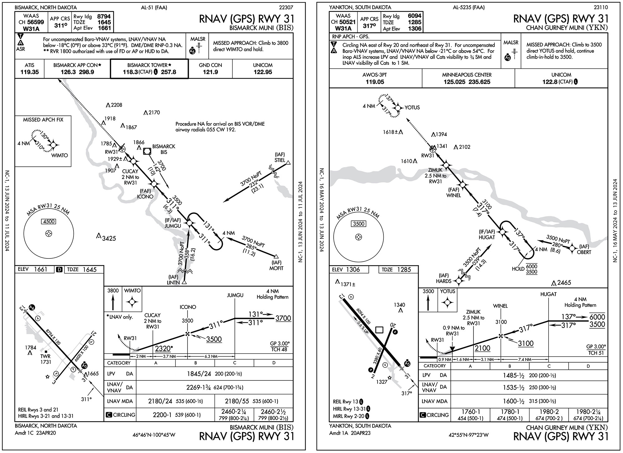
Otherwise it’s desirable, and so you plan a fuel stop right on the way at Bismarck, North Dakota. It’ll be MVFR there, so stay IFR as long as possible and plan the RNAV 31 to make things nice and comfortable. You know there will be enough to deal with fighting the winds and there will be another leg to go. On departure, note that for obstacles you should fly runway heading to 2200 feet before turning right.

At 1:30 p.m., you fire up and call for taxi right away. You got your clearance 30 minutes ago, and sure enough you get a taxi route before everyone else decided it was time to get their flight plans. Yes, you were in a bit of a hurry to get going, but you opted for the long trek to 28R given the conditions. And you also didn’t consider an intersection departure. Having more than 10,000 feet of runway below you while climbing into nearly immediate IMC is just another goal you sought for departing into low weather. 

After that, it only took seconds to be on top of the layers. Still over the airport while directed back around to the northeast, you could see the layers had started to break up, and the groundspeed was definitely picking up. The front was coming through. The tradeoff on that will certainly be headwinds on the return trip, and even today every landing to the northwest means extra time to get vectored or routed around the airport to set up for approach. Not to mention the turbulence, which made its presence known in cruise but really kicked in descending through 7000 feet. Still, you didn’t expend all your energy riding that in to a nice landing into the wind. The 2.5 hours to Bismarck ended up closer to three due to all that, but there were still half tanks remaining. The fuel burn was also still close to what you expected, but it felt good to top it off again for the second half.

Visual, Kinda

Once past the higher terrain, the second leg allowed for lower cruise—but you opted to stick to 9000 feet as it seemed a little smoother, and it reduced the fuel burn a bit too. So when Center initiated your descent to 7000 feet, you requested pilot’s discretion to hang out at 9000 for a few minutes longer. Meanwhile, you mentioned that you wanted a visual approach into Yankton with 1000 feet scattered. Legally that would allow for a visual clearance and you wanted to save a few more minutes of daylight. So pop in a three-mile visual approach, which you can pick up even from 3000 feet with the headwind. That would work as you’re still IFR and only need to remain clear of clouds with a visual to the airport.

The tradeoff—two, actually—is that meeting visual requirements once cleared isn’t assured if still above a scattered layer, and in the case of a go-around, there’s no missed approach procedure. Here, you can plan to fly the traffic pattern back around while remaining below the clouds (you are still on the visual approach flying IFR) and after landing, call back to cancel. 

If the scattered clouds are a problem, request the RNAV 31 with vectors inside HUGAT, which will only take a few more minutes. Or … see if you can get a visual approach via vectors to the final approach fix, WINEL. 

Provisions for visuals from a FAF are in the AIM (5-4-6, “Approach Clearance”). While this is more common at busy airports to sequence aircraft on nice days, you can certainly request it. Since there is no missed approach once “cleared for the visual” is communicated and read back, you still need to work something out ahead of time, or advise ’em of your plan to use the traffic pattern. In that case, the first option for a three-mile final seemed just as good as any.

The 30-knot, turbulent headwind took the most work, but it was still preferable to a low approach, dark approach, or one with additional weather hazards. Still, you knew you couldn’t handle another leg and would stay in Yankton even if it wasn’t the destination. By the time you landed and canceled, you’d made many more decisions than usual, flew hours more than you normally do in a day, and landed somewhere new. A day like that should definitely end with cake. 


Elaine Kauh is a CFII in eastern Wisconsin. Clear days being rare in her area, she plans for foggy mornings and cloudy afternoons and likes to be pleasantly surprised when it does turn out CAVU.

Ready to Sell Your Aircraft?

List your airplane on AircraftForSale.com and reach qualified buyers.

List Your Aircraft
AircraftForSale Logo | FLYING Logo
Pilot in aircraft
Sign-up for newsletters & special offers!

Get the latest stories & special offers delivered directly to your inbox.

SUBSCRIBE