Rocky Mountain Metro (KBJC), Denver RNAV (GPS) Rwy 30R
KBJC is a great option for those flying to Denver, but there are a few things to watch for on this approach.
More frequently used by general aviation traffic,
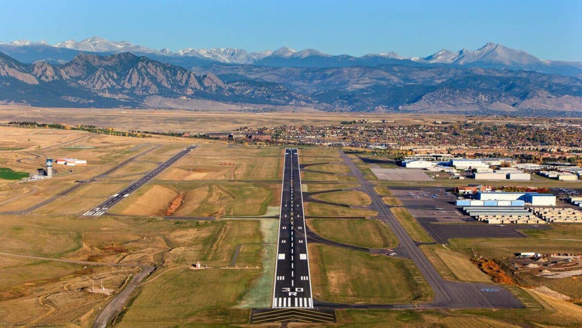
Rocky Mountain Metro Airport offers parallel runways and multiple FBOs. [Courtesy: Rocky Mountain Metropolitan Airport]
For those heading to the Denver area—especially those who plan to explore the north side of town—Rocky Mountain Metro Airport (KBJC) gives pilots a great option. More frequently used by general aviation traffic, this airport offers parallel runways and multiple FBOs. In the event of IFR weather, a pilot might choose to use the RNAV (GPS) Rwy 30R approach. In the spring-time, pilots should watch for mountain wave-induced winds that can hammer the mesa upon which the airport sits. Summer brings the thunderstorm season, though cells are often widely spread and easy to spot visually. A few other things stick out on this approach that a pilot should note before they head inbound.

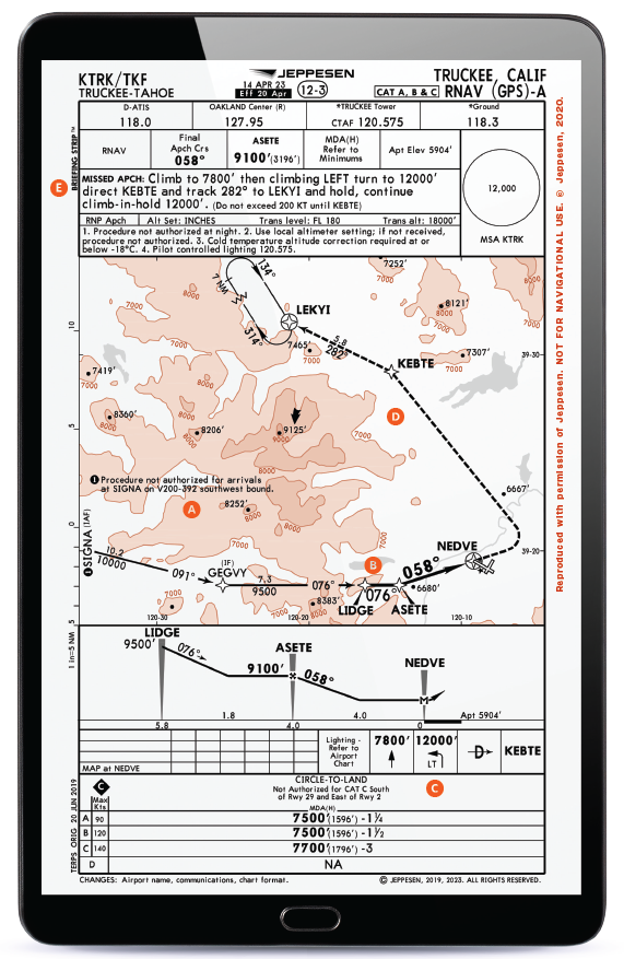
A. Multiple IAFs
Approaching from the south, a pilot might choose NSPYR or if from the north or east, ROKXX as the first point they select on their GPS to transition onto the courses for this approach. Each of these waypoints offers a pilot an opportunity to select a most efficient position from which to get established onto the approach and continue inbound.
B. Mandatory Altitude at LAWNG
Not something you see on all approaches, this approach has an inter-section that has a “Mandatory” altitude noted. When a pilot transitions from the PLAAY fix to the LAWNG intersection, they’re expected to be at 7,000 feet msl, not above or below it. It is not a minimum altitude—in this case, it is a mandatory altitude. This is most commonly used when ATC needs to route traffic across points where over- or underlying air-space may have other traffic transiting at different altitudes.
C. Minimums For WAAS and Non-WAAS
Knowing what approach minimums are applicable for the equipment in your aircraft is important. In this case, the two main approach minimums that most aircraft have to choose between are LPV and LNAV. Offering both of these options, the approach allows an air-craft capable of receiving WAAS to fly to LPV minimums that are lower than those for an aircraft not equipped with WAAS. Those without must fly to the LNAV minimums. A pilot will need to know what equipment they have and use it to select the proper minimums as they fly down the approach. In lower weather conditions, it might be the difference between getting in or not. Plus, the LPV will offer the pilot a GPS/WAAS-derived glideslope they can follow for a stabilized approach.
D. When To Go Missed
With “going missed climbing arrows” depicted at multiple points from the1.0 nm point with a “1”number note and a “V”(visual descent point)and, beyond it, an “M” at the RW30R point, a pi-lot might get confused at when they really need to go missed on this approach. To determine which missed approach point (MAP) to use, re-fer back to the question of which minimums apply. For the “1” note indication, going missed would happen only if the pilot was flying the approach as an LNAV (non-WAAS) approach. The RW30R point would be applicable to LPV or LNAV/VNAV approach minimums and would require the pilot to go missed at the decision altitude along the glideslope—if the runway environment was not in sight.
E. Missed Procedure Not to Scale
The missed approach takes a pilot first on a climb straight ahead to 6,300 feet and then up to 10,300 feet after aright turn to the HYGEN intersection—and it has a note that says it is “Not to Scale.” This is a hint to the pilot that there maybe “some distance” be-tween the missed and the missed approach holding point. To get the depiction to fit on the chart, they need to do this some-times. It means the pi-lot will need to be ready for a small—or in some cases longer—distance to where they will arrive at the holding point. You’ll want to be ready to read the distance from your GPS box as you transition.
Editor's Note: This article originally appeared in the Q2 2022 issue of FLYING Magazine.


Subscribe to Our Newsletter
Get the latest FLYING stories delivered directly to your inbox