
** It is hard to believe that such apparent mayhem
can be transformed into such tailored avionics
sophistication.**
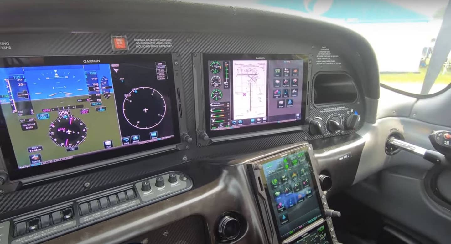
__Never have I enjoyed glass so much. This is even better than the Learjet martini glasses a friend gave to me — much more expensive too. Nor am I speaking of Dale Chihuly's glass concoctions. What we've done, my wife and I, is to replace the old instruments in our 31-year-old Cheyenne with the Garmin G600. While we were at it, we added another Garmin 430 and upgraded both to WAAS. The panel was completely redone. I left the Avidyne EX 500, which I love so dearly, right where it was.
Was it worth it? Yes. Did it cost a lot? As much as a new Mercedes, albeit the entry-level one. Is it spectacular? Affirmative. And, I haven’t really even figured it all out yet. I have concluded, however, that if I get lost now, it will be time to call it quits, stop by Wal-Mart, pick up a box of Depends and call it a day, or maybe a life.
Though the Avidyne was a game changer, what with its map featuring Nexrad weather, metars, TAFs and winds aloft, I couldn't keep my eyes off the Garmin. Since the Cheyenne commanded the G600, not the G500, synthetic vision came with the package. As in all fishing expeditions, the hook was finally set by a seasoned fisherman (read: avionics man), this one named Jack Shields. Jack, then of Lanmar Aviation in Groton, Connecticut, (now of Atlas Aircraft Center in Portsmouth, New Hampshire) sold me. Not that he had a lot of persuading to do, but when he saw me approach the lure, he played the line carefully. Next thing I knew, I was getting photographs of our panel, completely deconstructed. These images were terrifying.
Where sensible, time-honored dials and gauges had resided for three decades, there was now a gaping hole. Even a trauma surgeon would have gasped at the size of the cut. How, I wondered, could everything possibly be regrouped in a way that would allow me to trust the whole ensemble on a low approach? Was this really a good idea?
Fifty hours later, and still seeing new features each time I fly, I conclude that you should get some glass too. It makes you (well, me, at least) a better, more precise pilot. I know that hundreds of laudatory articles have been written by seasoned writers about the features of glass PFDs (primary flight displays) and MFDs (multifunction displays); I’ll leave the technical explanations to them. This is about one owner’s experience and one installation. Prices, specifics and satisfaction may vary.
Though my experience with avionics installations has been on the whole very good, on most major renovations there have been issues with fine-tuning the equipment or getting the local FSDO (flight standards district office) to release the 337 Form. Despite the scope of this work, there was only one minor correction needed. The airspeed tape, which is designed to mimic in color what the traditional airspeed indicator does, showed red for all airspeeds. This was instead of white, green, yellow and red/white “barber pole” colors used to denote flaps operating range, normal operating range, caution range and never exceed speed (Vne). That was it and it was easily fixed.
On the day of delivery, I flew by airliner to Providence, Rhode Island, and rented a car for the drive to Groton. The airplane looked great — there wasn’t a scuff on the carpet or a speck on the newly constructed and expertly painted panel. If the preceding sentence seems overburdened with superlatives, it is because the job was that much more than I had expected. I had picked a light beige for the panel, close to the original. I’ve had dark gray, blue and beige panels, but in dark weather, I like the cheerfulness of the warm color. A new panel means no black covers installed to fit where previously useful but no longer necessary instruments once plied their trade. It made the airplane look brand-new.

With Jack in the right seat, we fired up and taxied out while I whistled at the SafeTaxi GPS-driven map that alerted me to hot spots for runway incursion. With Jack giving a running commentary on various buttons and bells, we took off and circled for an ILS 5. As the autopilot caught the localizer, I was reassured that I could at least get started in the airplane without killing myself. In retrospect, I caught only about a third of what was going on.
Alone and proceeding VFR to an airport 150 nautical miles away, I managed to get airborne and headed in the right direction. I did note that I sought consolation and information from the gauge on the copilot’s side occasionally, just a habit of knowing about where 120 knots was on that round dial. Leveled off at 12,000 feet, I gingerly engaged the autopilot with my thumb poised over the disconnect button. The autopilot engaged effortlessly and without complaint. I took a deep breath.
The two 430s were linked in mysterious ways; putting “direct to” somewhere into number one resulted in the same “direct to” in number two! Multiple maps stared at me from the MFD. Topo and terrain, traffic and who knows what other indications eyed me with suspicion, as well they should. There were various buttons festooning the right and left side of the G600 with alluring titles like “baro” and “V/S.” Would I ever figure all this out?
Not yet. But 50 hours later, I have learned what a great situational aid this constellation of equipment represents. On an ILS to Raleigh-Durham, North Carolina (KRDU), multiple vectors would have left me dizzy but for the consistent and clear information on the map page of the Garmin and the Avidyne. The V bars, coupled with the wind vector right next to it, not to mention the green circle that represents the flight path marker — this is where the airplane is really going, regardless of what heading and pitch look like — made the approach to a 900-foot ceiling the perfect first date.
The synthetic vision is the real surprise. I had thought that it was just a gimmick with little practical application. Most of the time that might be true, but flying in the mountains of the northeast United States has moved my sentiments from the trivial-but-fun to the helpful and, maybe, lifesaving. Coming over Mount Ascutney, Vermont, on the descent, I could see the mountain both out the window and on the screen. It was eerily reassuring that information stored on a chip coupled with precise position information gathered from a satellite orbiting Earth could paint the picture so vividly. The terrain features, the traffic information and the blue of the Connecticut River made for a picture that was more than informative; it was so authoritative as to be spellbinding.
I can imagine that losing an engine on a low day would make the terrain features on the synthetic vision a great reassurance while sorting out which prop to feather and where to point the airplane. Speaking of pointing the airplane, once parked on the ramp our Cheyenne was pointed toward a low hill on the east side of the airport. You can see the hill on the G600 screen shot I took (shown on page 72).
New equipment takes some getting used to, no doubt about it. The tandem 430s and WAAS are new to me. On a recent approach I was given a heading, then given direct to the outer marker, and I got there by hitting the “direct to” button and switching from the heading mode to the navigation mode. I also had the localizer dialed in. I was surprised when the 430 automatically switched to VLOC and started to make a run for the localizer. Good thing the weather was good and the controllers were friendly.
I don’t suppose there is ever an excuse for the kind of financial commitment these sorts of upgrades require. Given the state of the economy and the fortunes of many, it may seem almost criminal to have such unabashed enjoyment from something so nonessential. One could argue that these upgrades stimulate the economy, but such a position would be disingenuous at best. I didn’t do these things for the good of the republic. I did them for me.
Send reader mail to: edit@flyingmag.com or P.O. Box 8500, Winter Park, FL 32789.


Subscribe to Our Newsletter
Get the latest FLYING stories delivered directly to your inbox