Relevant Discussion: AIM 4-3-26, 7-1-1, 7-1-11, 7-1-17, 7-1-29, 7-1-30, FAA-H-8083-16, 8083-25, AC 150/5220-16, order 8260.19F 8-6-6 Nathan Rambo
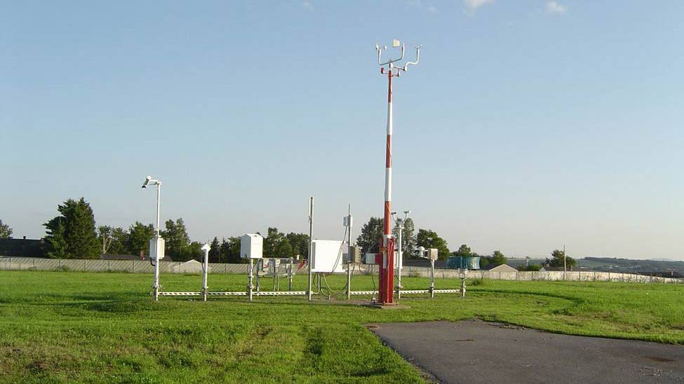
AWOS: Automated weather observing system. A suite of weather sensors of many different configurations either procured by the FAA or purchased by individuals, groups or airports that are required to meet FAA standards. AWSS — automatic weather sensor system — is functionally the same as ASOS.
A state or airport can purchase an AWOS with assistance from the FAA's Airport Improvement Program.
The system transmits a 20- to 30-second weather message updated each minute.
AWOS levels:
- AWOS-A — Only reports the altimeter setting.
- AWOS-AV — Altimeter and visibility.
- AWOS-1 — Altimeter, wind data (referenced to magnetic north), temperature, dew point and density altitude.
- AWOS-2 — Information provided by AWOS-1 plus visibility.
- AWOS-3 — Information provided by AWOS-2 plus cloud/ceiling data.
- AWOS-3P — Same as AWOS-3 and adds a precipitation type identification sensor.
- AWOS-3P/T — Same as AWOS-3P and adds thunderstorm/lightning reporting.
- AWOS-3T — Same as AWOS-3 and adds thunderstorm/lightning reporting.
- AWOS-4 — Contains all the AWOS-3 system sensors, plus precipitation occurrence, type and accumulation, freezing rain, thunderstorm/lightning and runway surface condition sensors.
AWOS can also generate automated remarks about density altitude, variable winds and ceilings.
A01 indicates a station without a precipitation identification sensor (i.e., cannot determine the difference between liquid or frozen/freezing precipitation).
A02 indicates a station with a precipitation identification sensor.
AWOS information can be obtained on the proper frequency in flight and by telephone on the ground.
An AWOS commissioned before July 1996 is not required to use the metar format. That means it might report temperature in degrees Fahrenheit, among other differences.
ASOS: Automated surface observation systems generally report at hourly intervals and also report special observations if weather conditions change rapidly. They generally report all the parameters of the AWOS-3, while also having the additional capabilities.
ASOS provides continuous observations necessary to generate a routine weather report (metar). They're more sophisticated than AWOS and designed to provide the necessary information to generate weather forecasts (TAF). ASOS is composed of a standard suite of weather sensors.
ASOS can determine type and intensity of precipitation (rain, snow, freezing rain), thunderstorms and obstructions to visibility such as fog and haze.
ASOS can also measure wind shifts, peak gusts, rapid pressure changes and the amount of accumulated precipitation.
The ASOS system shines a laser ceilometer into the sky to observe cloud layers. It takes a measurement every 30 seconds over a 30-minute period, then double-weighs measurements during the last 10 minutes so the computer can decide if the cloud layers are scattered, broken or overcast. Ceiling information is "time averaged" over a 30-minute period, and visibility over a 10-minute period.
The ASOS visibility sensor is normally located near the touchdown zone of the primary instrument runway.
The word "auto" included in the broadcast signifies that an observer is not logged on to the ASOS for backup or augmentation.
ASOS information can be obtained on the proper frequency in flight and by telephone on the ground.
ASOS and AWOS:
The flag word "test" is added to the voice transmission of an ASOS/AWOS when it is being tested before commissioning and the quality of the observations might not be up to FAA standards.
The upper limit of cloud height and visibility reported by ASOS/AWOS is 12,000 feet and 10 miles.
The most common reason ASOS/AWOS cannot be received by telephone is due to maintenance or repair.
Food for thought regarding AWOS/ASOS weather reports: The following is an excerpt from an FAA legal interpretation dated May 24, 2012, concerning VFR flight visibility reported by automated weather stations.
“You describe a scenario where a pilot on a VFR flight plan arrives at an uncontrolled airport in Class E airspace to the surface and picks up the AWOS information for that airport. The AWOS report states that there is a ceiling of 100 feet and visibility is one-fourth mile with calm winds. You further explain that the pilot flies over the airport and determines that there is a fog bank over one end of the runway which obscures the last 1,000 feet but the other 9,000 feet are clear.
“You asked whether a pilot in this scenario is in violation of §91.155 if he lands at the airport.
Yes, if the pilot lands at the airport in the scenario described above, he is in violation of §91.155. In order for a pilot to land an aircraft or enter the traffic pattern of an airport, ground visibility at the airport must be at least 3 statute miles. See 14 CFR §91.155(d). The AWOS is reported a ceiling of 100 feet and visibility of one-fourth mile. This clearly does not meet the visibility requirements as outlined in § 91.155. The pilot’s report of flight conditions cannot supersede the AWOS in this scenario. The determination of the visibility by a pilot is not an official weather report or an official ground visibility report.”
Note: FAA regulations could change at any time. Please refer to current FARs to ensure you are legal.

Subscribe to Our Newsletter
Get the latest FLYING stories delivered directly to your inbox


