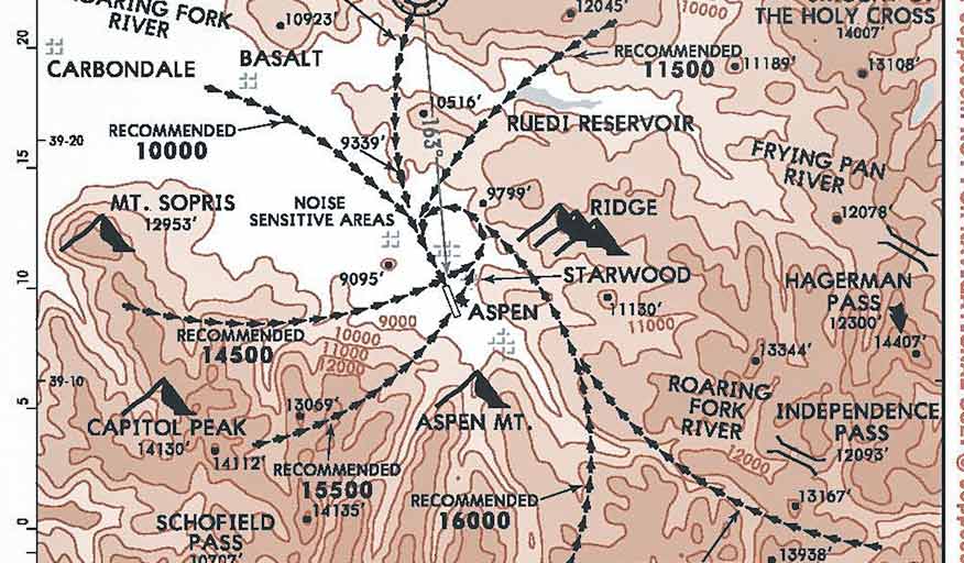
Visual approaches offer pilots an opportunity to remain within the IFR system but fly direct to the airport on their own. Once ATC issues a visual approach, however, responsibility for navigation and terrain clearance is transferred from the ground to the cockpit. Avionics manufacturers recently began adding visual-approach capabilities to their navigation suites to create an extended runway centerline and an imaginary final approach fix. Unfortunately, computer-drawn visuals do not provide terrain or obstacle clearance. This month’s approach, Aspen’s Roaring Fork visual, does provide terrain and obstacle clearance, assuming, of course, the pilot adheres to the recommended altitudes.
Chart Wise: Training and Technique
Key Takeaways:
- The Roaring Fork visual approach at Aspen transfers navigation and terrain clearance responsibility to the pilot, uniquely providing terrain and obstacle clearance if recommended altitudes are adhered to.
- This visual approach has strict operational requirements, including local weather minimums of 6,000 ft ceiling and 10 miles visibility, mandatory active radar assistance, and is not authorized after dark.
- It lacks traditional initial and final approach fixes, requiring radar control to establish the approach start point, and offers no official vertical guidance until a visual lock on the Runway 15 PAPI can be established.
Key takeaways sponsored by Aviator Pro | Start Your Training ->
See a mistake? Contact us.
