fbpx

Holland, Michigan, ILS or LOC Runway 26

A trip to the tulips on this approach

When most people think of Holland, wooden shoes, canals, windmills and tulips are often top of mind. But that’s the Holland on the east side of the Atlantic actually known as the Netherlands. The subject of this month’s Chart Wise, Holland in the western part of Michigan, does bear some similarity to the European country for which it was named. Each May, the city’s Tulip Time Festival recalls Holland’s Dutch roots and brings visitors from all around the nation to see the variety of flowers blooming around the city. The airport, originally called Tulip City, is a regular destination for one of this column’s authors. While the ILS approach to Western Michigan Regional (KBIV) isn’t terribly challenging from a flying perspective, the chart does include a couple of notations that aren’t commonly highlighted and might prove confusing to new instrument pilots.

A. Ground-Based ATC Communications

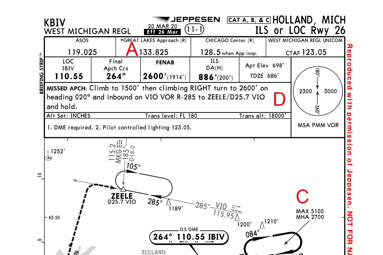
Though the airport is nontowered, the chart lists 133.825 as the frequency for “Great Lakes Approach,” a convenience that could be overlooked. Great Lakes can communicate with pilots on the ground, offering the opportunity to open or close IFR flight plans without using the phone. For clearances, take a look at the airport chart to view the clearance delivery frequency of 123.95.

B. Two DMEs Listed at the Intermediate Fix JAVPO

The ILS Runway 26 approach is commonly joined via the feeder route to JAVPO from the Pullman VOR (PMM) or via radar vectors from Great Lakes Approach. Pilots should, however, pay close attention to what navigational aid they’re using to identify the intermediate fix because it’s defined as both 13.2 nm along the IBIV localizer or 22.4 nm from PMM. Each uses a different frequency.

C. The Hold at JAVPO

The holding pattern depicted at the JAVPO intersection includes notes requiring a minimum holding altitude of 2,700 feet and a maximum holding altitude of 5,100 feet. These kinds of restrictions are most commonly used when there is potential overflight traffic that could conflict with aircraft at other altitudes. Grand Rapids Michigan Airport (KGRR), 27 miles northeast of JAVPO, is a busy commercial facility, for instance.

Check out more charts: Chart Wise

D. Missed Is Anything but Direct

The missed approach procedure to the ZEELE intersection can be a little confusing because the VOR that partially creates the intersection is not used in any other way until the missed approach. That can make the Victory VOR (VIO) frequency easy to miss until the pilot begins that initial climb straight ahead to 1,500 feet before making a right turn to a heading of 020 and climbing to 2,600 feet to intercept the VIO 285 radial, which begins off the chart. If you’re questioned about the hold entry after crossing the 185 radial of Muskegon VOR (MKG) and you chose course reversal back to ZEELE, you’d be correct. A GPS or DME could also be used to identify ZEELE.

E. Checking Notams Is Important

Awareness of current ground-equipment outages is always important, but for this approach, they can often be critical. Pilots who regularly fly to KBIV say the MKG and PMM VORs used to identify cross radials and the approach’s feeder route are often out of service, which means if your aircraft is not GPS-equipped, shooting this approach might at times be impossible.

F. Time Block, but No Time Listed

While a descent-rate box still exists below the approach’s profile view, confirming the need for a 3-degree glideslope, notice there are no times mentioned at the listed groundspeeds. This is because of the requirement to identify the missed approach point using DME—in this case, 1.2 DME from the localizer—or the decision height when flying this approach as an ILS. Hence, timing does not apply, even if the approach is flown as localizer-only.

This story appeared in the September 2021 issue of Flying Magazine

Login

New to Flying?

Register

Already have an account?