fbpx

Chart Wise: Branson RNAV (GPS) RWY 32
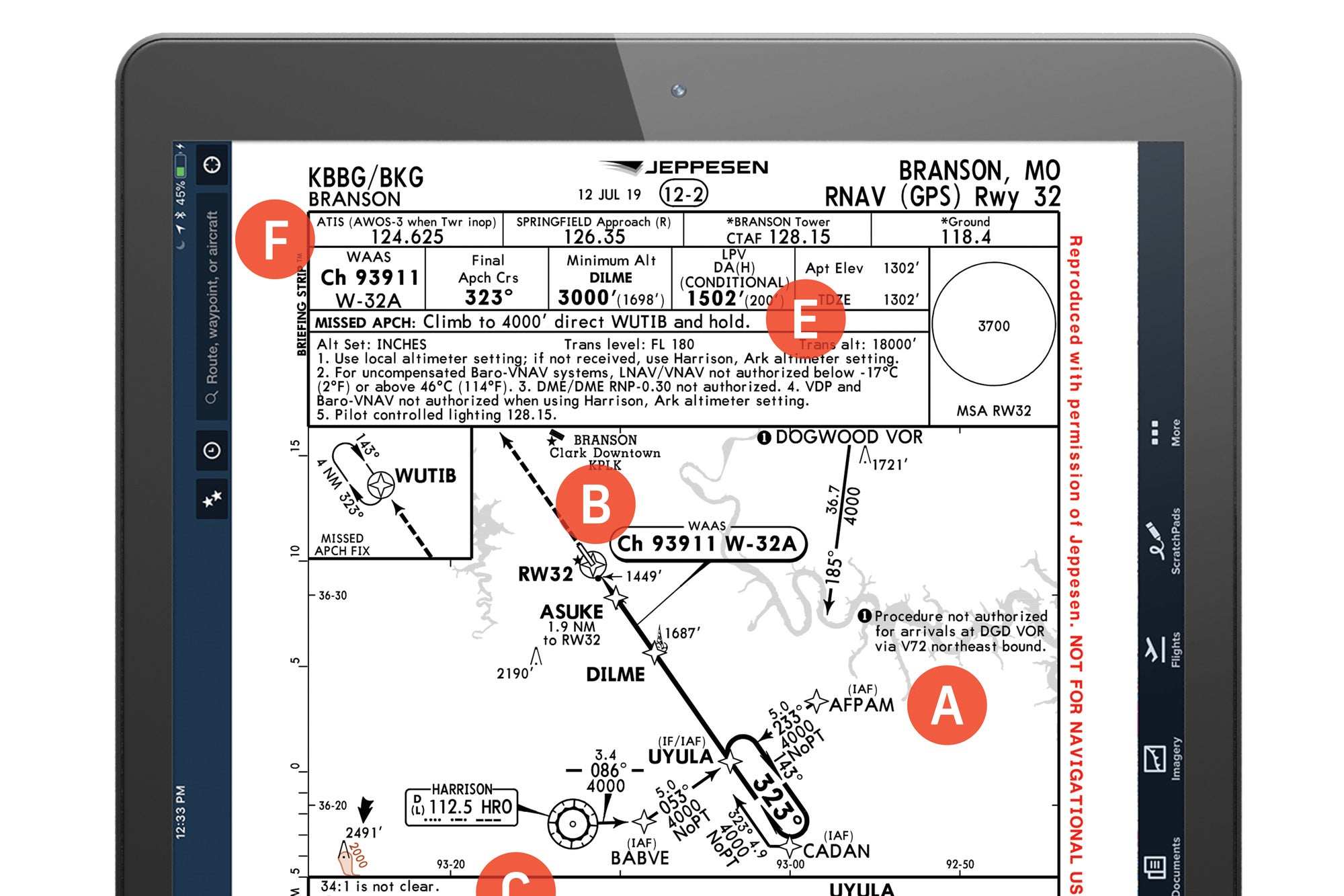
Watch for a similar-looking airport nearby.

Until the recent slowdown in travel because of the COVID-19 virus, Branson, Missouri, was a top destination in the Ozarks for families with kids, boasting a host of live shows, restaurants, golf courses, museums, hiking trails and much more. While everyone hopes the lull in flying to getaways such as Branson will be short, the current downtime offers pilots a perfect opportunity to tune up their IFR chart-reading skills. This time, we offer up the RNAV (GPS) Runway 32 approach into Branson’s privately owned, public- use airport (KBBG), sporting a 7,140-foot runway where most of the traffic is itinerant, not local flight training.

A. Aligning With the Final Approach Course

Most pilots generally expect vectors to the approach when transitioning from the en route environment, but this isn’t always the most efficient arrival method. Branson’s RNAV (GPS) offers three initial approach fixes posted in a standard T-bar configuration. Approaching from the north or east, a pilot might choose either the AFPAM waypoint or the Dogwood VOR to start the transition. From the south or west, a pilot might choose the Harrison VOR or the UYULA intersection. But why not accept radar vectors? Because using one of these arrival points often establishes an aircraft on a course—and sometimes at a lower altitude than with vectoring. This is the case at KBBG, located some 50 nm from Springfield, Missouri, where the FAA staffs the terminal radar approach control.

B. Choose the Right Airport

In the plan view of the KBBG chart, pilots should note the depiction of the M. Graham Clark Downtown Airport (KPLK), a facility with a similarly aligned though shorter Runway 12/30. To avoid being one of many pilots who have accidentally landed at the wrong airport over the years, this is worth adding to every approach briefing. It could very well prevent calling the wrong runway in sight during marginal weather.

C. Step-Down Considerations for Non-WAAS Aircraft

Arriving in the Branson area in a non-WAAS-capable airplane means flying the approach to LNAV MDA minimums instead of following the LPV glideslope. Pilots should be prepared to disregard a “suggested glideslope” that might appear—a slope that could take them below 1,940 feet MSL before crossing ASUKE 1.9 nm from the runway threshold. At 1.1 nm from the RW32 waypoint, the aircraft should be at or above the MDA of 1,700 feet (using the local KBBG altimeter) because of Note 2 in the plan section of this plate, which indicates that a glidepath with the standard ratio of 34-to-1 is not clear of obstacles prior to reaching this point. Put simply, descend early and you could hit something.

Check out more charts: Chart Wise

D. Glidepath Angle and Required Descent Rate

Most of us assume we will be flying a typical approach at a descent rate of about 500 feet per minute. Not on this approach, where groundspeed is important. A chart just below the profile view states the expected descent rate required in feet per minute for a corresponding groundspeed to match a 3-degree glidepath angle. An aircraft flying at 90 knots groundspeed requires a descent rate of 478 feet per minute. A faster groundspeed calls for a corresponding increase in the rate of descent.

E. A (Literally) Straightforward Missed Approach

KBBG offers one of the easiest missed approaches we’ve seen in some time. Climb straight ahead to 4,000 feet MSL to WITUB, and use the entry method of your choice for the required 4 nm legs—but not one-minute inbound legs. The good news is, most GPS systems coupled to a three-axis autopilot will handle the work.

F. Who You’ll Be Talking To

Planning for the necessary ATC frequencies ahead of time offers an opportunity to set up the active and standby radio frequencies to avoid doing so in a last-minute rush. That job is made easier by following the sequence in the briefing box near the top of the plate: ATIS is available on 124.625, Springfield approach control on 126.35, tower on 128.15 and even ground control on 118.4, if there’s time.

This story appeared in the June/July 2020 issue of Flying Magazine


Login

New to Flying?

Register

Already have an account?