fbpx

Chart Wise: Bar Harbor RNAV (GPS) RWY 22
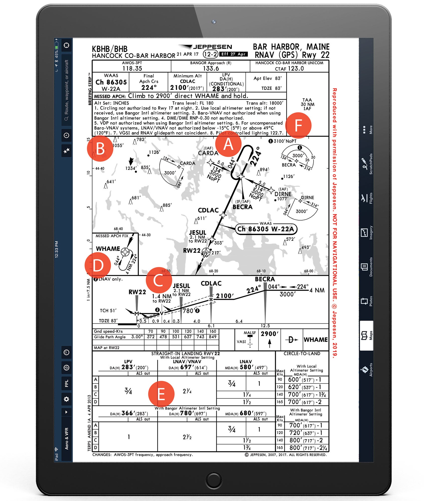
Standard T-Bar and Straight-Ahead Missed.

Whether you’re flying to the Maine coastline to add your name to the list of the 3 million annual visitors to Acacia National Park or to try to decide which restaurants really are the 10 best for lobster in the region, you might come face to face with the RNAV (GPS) Runway 22 for an approach into Hancock County-Bar Harbor Airport (KBHB).

Coastal influences here usually prevent winter temperatures from dropping down into the single-digit range common in the rest of Maine, but pilots should keep in mind that KBHB receives an average of 60 inches of snow. In May and June, there can also be dense coastal fog to plague unwary pilots.

A. Standard T-Bar IAF points

Whenever possible, GPS approaches are developed using a “T-Bar” shape. In this case, the final approach course is 224 degrees inbound with initial approach fix points CARDA and DIRNE to the northwest and southeast that require no more than a 90-degree turn inbound and eliminate the need for a turn around the holding pattern.

B. Differing Glideslopes

Note 7 warns pilots that the visual glideslope indicator and the RNAV glidepath are not coincidental. That means if you are flying the glideslope on the instruments, and break out of the clouds, the lights indicating the visual glidepath will not match up with the one you are flying using your instruments. This becomes a decision point for the pilot. If you are confident you can continue the rest of the approach visually, you could transition to using the visual glideslope indicator; if that isn’t certain, you may be better off continuing use of the glidepath on your instruments.

C. Do Step-downs Matter?

The answer is: It depends on the weather and if a pilot is flying the LPV or LNAV version of this approach. After passing BECRA, the pilot is authorized to descend from 3,000 feet to 2,100 feet until crossing CDLAC, the FAF. To the untrained eye it may look as if there may be additional step-downs at JESUL, 2.1 nm to Rwy 22, and perhaps even at 1.4 nm. These would not be applicable to a pilot flying this approach to the precision-like LPV minimums. But for a pilot flying the approach to the non-precision-like MDA minimums, JESUL denotes a minimum altitude—780 feet—the pilot could be at when crossing that point. That altitude is likely because of the 303-feet-tall obstacle noted in the overhead view. The 1.4 nm point to Rwy 22 denotes the visual descent point, a location from which the pilot would use normal descent maneuvering if they have the runway environment in sight.

D. Holding Patterns Are Slightly Different

Should a missed approach become necessary, the pilot climbs straight ahead to 2,900 feet proceeding directly to WHAME intersection to hold. But unlike traditional 1-minute legs, this hold uses 4-nm legs, which are common on modern GPS approaches. Most GPS systems connected to an autopilot will fly these for you. If you’re hand-flying the airplane, don’t let old habits convince you to fly 1-minute legs.

E. Minimums Increase Without The Local Altimeter

Pilots unable to receive the KBHB altimeter must increase their landing minimums—numbers that can found on the bottom of the plate. Sometimes, the change in minimums can mean the difference between a successful arrival and a missed approach. On this approach for instance, minimums with the local altimeter are 283 feet and 3/4-mile visibility. Using a Bangor altimeter setting, those minimums would climb to 366 feet and 1-mile visibility. If you typically round up minimums to the next 100 feet to avoid busting minimums, it would mean a missed approach at 400 feet—instead of the 300 feet—for pilots without the local altimeter setting. So that extra 100 feet can make a big difference.

F. Got the Lights Yet?

Pilot-controlled lighting is fairly common when there aren’t any folks nearby to turn them on or raise the intensity. Just click your microphone button on the right frequency to light up your life. If want to control them at a nontowered airport like KBHB, what frequency would you use? If you answered quickly and said CTAF, you’d be wrong. CTAF is often a great answer, but in this case, Note 8 says the PCL is operated through 122.7.


This story appeared in the April 2020 issue of Flying Magazine

Login

New to Flying?

Register

Already have an account?