













Telluride is located in southwestern Colorado. Originally, it was a silver mining camp. The town was founded in 1878 as “Columbia” but was renamed the following year as Telluride for “gold telluride,” for ores of the chemical element tellurium. While gold tellurides were not found there, other ores of metals such as lead, zinc, and silver were. Present day, Telluride is an all-season resort where you can ski in the winter and turn to hiking and biking in the summer. Geographically, it sits in a box canyon, which affects the approaches to Telluride Regional Airport (KTEX). The town is at an elevation of 8750 feet MSL, and the airport is even higher at 9070 feet MSL. Surrounding mountains reach over 13,000 feet MSL.
Telluride Airport is perched atop a manmade mesa, with mountains encircling it north, east, and south. Notably, there are drop-offs at both ends of the runway. However, to ensure safety, both runway ends are equipped with EMASs (Engineered Material Arresting System) beyond the thresholds, allowing for quick stops and providing security.

Telluride Airport offers four approaches, all leading to Runway 9. Due to the more challenging mountainous terrain to the east, instrument approaches to Runway 27 are not feasible. The available approaches are RNAV (GPS) Y RWY 9, RNAV (GPS) Z RWY 9, LOC RWY 9, and VOR/DME RWY 9. For simplicity, I’ll refer to the first two approaches as “Y” and “Z.”
Required Aircraft
When planning a flight into and out of Telluride, it’s crucial to consider the specific aircraft requirements. The airport’s elevation is 9070 feet MSL, and on a ‘warmish’ day at 65 degrees F, the density altitude would be over 11,000 feet. Additionally, nearby MEAs are between 12,000 and 16,400 feet MSL. In light of these factors, a turbocharged or turbine-powered airplane is recommended. However, with careful planning, normally aspirated airplanes may be suitable in benign IMC weather. It’s also important to note that having oxygen is likely a necessity.
RNAV (GPS) Y RWY 9 and RNAV (GPS) Z RWY 9
Having a Y and Z in the title indicates that there are two approaches to the same runaway using the same technology; in this case, GPS, but there are some differences. But first, let’s look at the similarities.
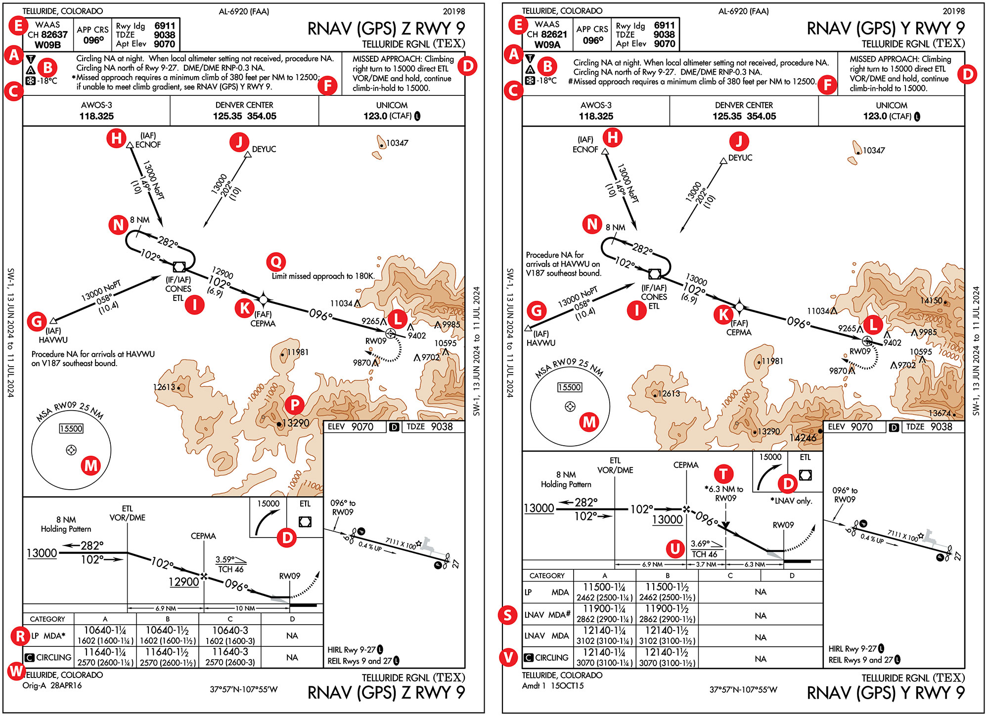
The triangle [T] indicates non-standard take-off minimums (A). Interestingly, IFR take-offs from Runway 9 are not authorized (NA) due to rising terrain within a few miles. Typically, we are not concerned about non-standard take-off minimums for landings. But here we should be. Most likely, this might indicate the missed approaches to Runway 9 will require immediate turns to the west, as we’ll see later.
Taking off on Runway 27 requires climbing to 12,000 feet MSL to ETL VOR and continuing climbing to 14,200 feet MSL in a hold. Another option is a VCOA (Visual Climb over the Airport) to 14,300 feet MSL or higher. Details are found in the U.S. Terminal Procedures Publication.
The airport also has non-standard alternate weather conditions (B) that are quite high. For Runway 9, instead of the standard non-precision 800-2, the alternate minimums for Y and Z approaches are 3100-2 and 2600-2 (CAT C 2600-3), respectively, requiring substantially higher forecasted or actual ceilings.
Not surprisingly, given the location and elevation, the snowflake (C) indicates that Telluride Airport is also a “cold weather airport” that requires altitude adjustments along the final approach segment when the temperature is -18 degrees C or lower. (See “Cold and Other Issues,” in IFR, January 2024)
The missed approach procedures for Y and Z are the same, (D) but look out for the keywords “Climbing right turn.” Typically, a missed approach requires a straight-ahead climb before turning. When an immediate turn is needed, it suggests obstacles ahead, resulting in a higher height at the missed approach point. It would not be advisable to turn in IMC at a low height.
Some navigators allow loading of WAAS-enabled GPS approaches using a WAAS Channel number (E). The “W” refers to WAAS, “09” the runway, and “A” or “B” the particular approach. In this case, there are different RNAV approaches to the same runway rather than RNAV approaches to parallel runways.
Interestingly, Y and Z missed approaches require a climb gradient of 380 feet/NM to 12,500 feet MSL (F). The gradient translates to climb rates of 570 FPM and 760 FPM at ground speeds of 90 knots and 120 knots, respectively. The standard climb gradient is 200 feet/NM. However, the Z approach notes: “If unable to meet the climb gradient, see RNAV (GPS) Y RWY 9.” More on this later.
The PlanView
The PlanView for the Z approach, which is very similar to the Y approach, is shown. The two approaches have the same segments (initial, intermediate, and final). Instead of a typical “T- shaped” approach, it is a “Y-shaped” approach mainly driven by the two IAF HAVWU (G) and ECNOF (H), which are also fixes on nearby airways. Both initial segments are annotated NoPT (No Procedure Turn) to the third IAF/IF at CONES (I). DEYUC to CONES (J) is also a flyable route, which would require a procedure turn entry at CONES.
Notice a 6-degree kink at CEPMA (K) between the intermediate and final approach segments. This will affect the minimums, as we’ll see later. As is typical of most RNAV approaches, the missed approach point (MAP) (L) is over the Runway 9 threshold. The Minimum Safe Altitude within 25 NM from Runway 9 (M) is 15,500 feet MSL, and because the approaches are RNAV, only one sector is shown. Additionally, given that the holding pattern altitude at CONES is 13,000 feet MSL, it has an eight NM outbound leg (N) rather than the four NM leg common at lower altitudes.
There are some differences between the PlanViews of the Y and Z approaches. The highest elevation in Z (P) is 13,290 feet MSL (the bolded value gives it away). However, in the Y approach, which has a slightly different printing layout, the highest elevation shown is 14,246 feet MSL, located very close to the 13,290 foot MSL elevation. The other difference is the annotation: “Limit missed approach to 180K” (Q) on the Z but not on the Y.
Profile Views
When there are two approaches, Z and Y, typically, the approach with the lowest minimums (altitudes and/or visibility) is the Z approach. Due to the Z approach kink at CEPMA, the straight-in minimum (R) reflects a nonprecision approach flown to LP MDA; otherwise, it might have had an LPV DA. The LP approach will not provide a glide path, but an “advisory” glide path might be available depending on the navigator. However, it would still be considered a nonprecision approach. Additionally, it also requires a WAAS-enabled GPS receiver.
Once at the MAP, at the MDA, the HAT (Height Above Threshold) will be 1602 feet, making a straight-in landing nearly impossible. Furthermore, a missed approach requires an immediate climbing turn (D) due to the mountainous terrain east of the field. Unlike a typical straight-ahead climb during a missed, the HAT must be higher when an immediate turn is required. As mentioned, turning at low heights is not a good practice for safety reasons.
The asterisk next to the MDA (R) requires a climb gradient of 380 feet/NM, found in the Notes Box (F). It also mentions that if you cannot comply with the required climb gradient, you need to refer to RNAV (GPS) RWY 9 Y version. Finally, note that there are no CAT D minimums.
The Y approach can only be flown at CAT A and B speeds and does not necessarily require WAAS-enabled GPS when LNAV minimums are published. The LP MDA is higher, at 11,500 feet MSL (S), compared to 10,640 feet MSL for the Z. Unlike the Z approach, the Y approach has an LNAV-only VDP T 6.3 NM from the runway threshold. At that distance, the minimum visibility of 1¼ SM (CAT A) or 1½ SM (CAT B) is insufficient to see the runway environment at low IMC. This suggests descending to the MDA promptly will increase the probability of seeing the runway at a distance that will allow a normal VMC descent. Notice that the suggested Visual Descent Angle (VDA) U of 3.69 degrees is higher than the more common 3.00.
The lowest LNAV MDA of 11,900 feet MSL with the # symbol (S) assumes a climb gradient of 380 feet/NM. If the airplane cannot comply, the relevant MDA is 12,140 feet MSL. The additional 240 feet allows for a more sedate 200 feet/NM or less climb gradient.
Interestingly, notice that the circling altitude (V) is 12,140 feet MSL (Y) compared to (W) 11,640 feet MSL (Z), a difference of 500 feet. This appears odd since a circling approach is a VFR maneuver, and the published altitude should be the same for the Y and Z circling approaches. However, the limitation in the Y approach is that the circling altitude cannot be lower than, but could be equal to, the altitude above, in this case, an LNAV MDA of 12,140 feet MSL.
VOR/DME-A
Another approach option is the VOR/DME-A (a) with only circling minimums (b). At first look, it seems it is correctly titled since DME is required to fly the final approach segment specifically to identify the FAF at IKHAF (c) and the MAP at MAPSY (d). Not so fast. The FAA AIS charting office informed me that the naming “convention has changed, and procedures are no longer named ‘/DME.’ The ones that are will have the title name changed the next time the procedure is amended.” Instead, the planview will have in bold DME REQUIRED. Of course, GPS may be used instead of DME.
The MAP at MAPSY is 5.2 NM to the Runway 9 threshold so it is not surprising that the required visibility (e) is six SM (5.2 nm). However, the reported visibility is at the airport on the AWOS-3 on 118.325 MHz (f), so the visibility might be quite different at a six NM distance. If the runway environment is not clearly visible at MAPSY, it is time to go missed rather than continue hoping the runway will be visible closer in. Notice the missed approach procedure (g) states that an “immediate climbing (right) turn” is required at MAPSY.
The MDA (e) is a high 12,420 feet MSL, which implies a HAT of 3350 feet AGL based on the airport elevation (h) of 9070 feet AGL. This could be misleading since, when flying over mountainous terrain, the actual height above the terrain might be variable even when maintaining a constant altitude. Also, notice that for a circle-to-land approach, there is no value for the Touch Down Zone Elevation (TDZE) or length of the landing runway.
The graphics play a trick on our eyes. The intermediate segment towards IKHAF is at 12,500 feet MSL. It would appear that after we overfly IKHAF (c), we do a death-defying dive (i) to the MDA, but we only need to lose 80 feet in 4.8 NM.
However, once passing the MAP (MAPSY) (d), and having the Runway 9 environment in sight, we need to lose 3350 feet in 5.2 NM or about 645 feet/NM. Flying at a ground speed of 90 knots requires a descent rate of 975 FPM; if flying at a ground speed of 120 knots, the descent rate would increase to 1290 FPM.
Luca F Bencini-Tibo believes that for flight safety, one must consider aircraft climb, descent, and ceiling capabilities, especially when flying in mountainous areas with high density altitudes. Additionally, instrument approaches should be first flown in VMC or in a sim.


