













Hybrid Approaches

Perhaps you call them “Frankenstein” approaches since these require both RNAV (GPS) and conventional navigation, grabbing pieces from each.

Gemini Sparkle

Key Takeaways:

  • The ILS or LOC RWY 21 approach at Stevens Point Municipal Airport (KSTE) is a "hybrid" procedure, uniquely requiring GPS for initial approach fixes and missed approach segments, despite its traditional ILS designation.
  • This integration of GPS into traditional approaches reflects a broader industry trend towards Performance-Based Navigation (PBN) and increased reliance on GPS as legacy ground-based navigation aids are phased out.
  • Pilots flying at KSTE must be aware of operational considerations such as the ILS approach being "NA" for alternate planning and the potential for lower decision altitudes with the ILS if using WAAS-capable GPS compared to non-WAAS RNAV.
  • The article highlights ongoing confusion and potential future changes in approach naming conventions (e.g., RNAV, RNP APCH, and ILS/GPS) as GPS integration blurs the lines between traditional and modern navigation procedures.
See a mistake? Contact us.

Stevens Point is located approximately in the middle of Wisconsin, along the Wisconsin River, which loggers used to transport logs on the way to market. The city dates back to the mid-1800s and was named after George Stevens, who owned a grocery and general store that served the logging community.

Stevens Point Municipal Airport (KSTE) is about three miles northeast of the city’s central business district. It is recognized by the FAA as part of the National Plan of Integrated Airport Systems for 2021-2025, thereby categorizing it as a regional general aviation facility. This allows the airport to receive federal grants under the Airport Improvement Program.


The airport has two runways, and each of the four ends has an RNAV (GPS) approach. Runway 21 also has an ILS. It does not have STARs or SIDs.

ILS or LOC RWY 21

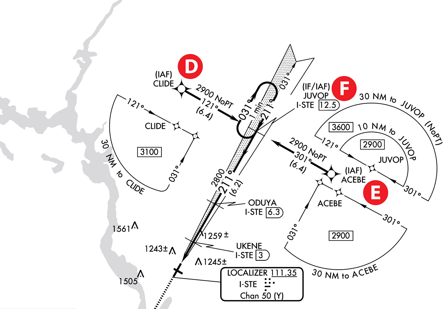
The approach is correctly titled an ILS or LOC approach since the LOC (I-STE) provides lateral navigation guidance along the final approach course. A The localizer also has a collocated DME (TACAN) identified by “Chan 50 (Y),” which is the channel number used by military aircraft to tune DMEs. B If we have on board DME equipment (not common today in light civilian aircraft), we select the DME UHF frequency by dialing the ghost VHF localizer frequency (111.35 MHz), paired with the DME UHF frequency. DME is required for this approach, but we can use an IFR GPS. C

But wait! Looking at the plan view, this ILS looks more like an RNAV (GPS) approach. It has the traditional “T” or “Basic-T” structure with two IAF (initial approach fixes) at each end of the “T”: CLIDE D and ACEBE E and a middle IF/IAF (intermediate fix), JUVOP F. Additionally, it has a TAA (Terminal Arrival Area), which eliminates the need for an MSA (Minimum Safe Altitude).

It is also an RNAV approach (actually an RNP APCH) to the extent that GPS is required. (See sidebar on the naming convention.) G GPS isn’t just nice to have here; it is an integral part of the approach, required to fly the IAFs and missed approach holding fix.

AIM 5-4-5 mentions that “The TAA provides a transition from the en route structure to the terminal environment with little required pilot/air traffic control interface for aircraft equipped with Area Navigation (RNAV) systems. A TAA provides minimum altitudes with standard obstacle clearance when operating within the TAA boundaries. TAAs are primarily used on RNAV approaches but may be used on an ILS approach when RNAV is the sole means for navigation to the IF; however, they are not normally used in areas of heavy concentration of air traffic.” (Emphasis added.)

One way to think about TAA altitudes is not emergency altitudes like in MSAs but MEA (minimum en route altitudes). Once inside the TAA and cleared for the approach, a pilot can descend to the published altitude unless given a higher altitude. For example, approaching from the northeast, between 30 and 10 NM from JUVOP F, the minimum altitude is 3600 feet MSL, followed by 2900 feet MSL within 10 NM. Notice flying from CLIDE D and ACEBE E to JUVOP; no reversal procedure is required. However, if flying directly to JUVOP F from the southwest, a hold-in-lieu of a procedure turn (HILPT) is required. A good practice during pilot-NAV is to fly to an IAF at the end of the “T,” eliminating the need for a course reversal.

The “Big Picture”

While not uncommon, a further indication that something is different is the lack of an approach-control frequency. Instead, Minneapolis Center provides approach services. H According to AIM 5-4-3, “ARTCCs are approved for and may provide approach control services to specific airports. The radar systems used by these centers do not provide the same precision as an ASR/PAR used by approach control facilities and towers, and the update rate is not as fast. Therefore, pilots may be requested to report established on the final approach course.” Additionally, due to the imprecision of radar vectors, they typically cannot be used to fly to a waypoint but to a course or a heading (for traffic separation); even if Minneapolis Center provides radar vectors to the final approach course, the best way to fly this approach is for pilot-nav using GPS to fly to one of the outer IAFs rather than accepting less precise radar vectors to the final approach course.

It is also important to look at the big picture. For example, are Victor Airways, T Routes, VORs, and MON airports nearby?

Sometimes, as a planning exercise, it pays to become familiar with the surrounding airspace, including airports.

There is a T route (T464) north of KSTE and a Victor airway (V191) to the east. There are no VORs nearby. Green Bay Austin Straubel Airport (KGRB) (and GRB VOR) are located 60 NM to the east. Also, Baraboo/Wisconsin Dells Regional Airport (KDLL) (and DELLS VOR) are 62 NM south. Both airports are MON (Minimum Operational Network) airports. Such airports allow ground-based navigation to fly to them (namely VOR) and shoot an ILS, LOC, or VOR approach during a GPS outage. Knowing the location of MON airports near the destination is good practice as a flight-planning exercise.

In discussing this with the FAA, I questioned if this hybrid-type approach (both GPS and terrestrial VHF nav) will become more common. The response was, “With the legacy NAVAIDs (i.e., VORs) being removed across the NAS (National Airspace System), you will see more of these hybrid procedures.” Additionally, I queried whether these approaches should be titled as ILS/LOC/GPS RWY XX approaches to reflect that GPS is an integral part of the approach. “Your point is well taken on the procedural naming, which Flight Standards will address at some point.”

Even though the airport can receive federal grants under the Airport Improvement Program, I wonder if the ILS equipment will eventually require costly maintenance resulting in it being decommissioned instead of repaired?

RNAV (GPS) RWY 21

The GPS RWY 21 approach is similar to the ILS or LOC RWY 21 approach. Both use the same waypoints and missed approach procedure. The decision altitude (DA) and visibility minimums are also the same: 1360 feet MSL and visibility 3/4 SM for the ILS and the LPV. The LOC and LNAV also have the same MDA at 1520 with 3/4 SM vis and circling mins are the same for both approaches.

A follow-up issue is why we would fly the ILS approach, which requires using GPS to an IAF, then changing the NAV source to VHF NAV (LOC with paired GS), and then back to GPS for the missed approach. A good reason to fly the ILS would be for recurrent practice and training. Another would be if the IFR GPS is not WAAS capable, then the RNAV would only get you to an MDA of 1520 feet MSL compared to the ILS DA of 1360 feet MSL. A difference of 160 feet at times could make the difference between landing and a missed approach.

Alternate minimums apply to specific approaches, not to the airport. Both approaches are annotated as having non-standard alternative minimums. For the ILS approach, the non-standard minimum is labeled NA (not authorized), which means this approach is unavailable for alternate planning because the ILS is not monitored. K For the GPS approach, the non-standard alternate minimums apply to CAT C and D aircraft (800-2¼ and 800-2½, respectively, compared to the standard 800-2). L However, the GPS approach is not authorized as an alternate without local weather.

Loading GPS Approaches

While different GPS navigators have different ways to load GPS approaches, the general steps are similar: select the airport, then the specific approach, and the transition: vectors-to-final (VTF), usually the default choice or an IAF. However, another way to load an approach is using a WAAS channel number, assuming the GPS navigator can use a channel number. M For GPS RWY 21, the channel number 86511 is specific to this approach. However, the transition IAF or the default VTF must still be selected. Channel numbers are only available for approaches with LPV and LP mins since they require WAAS. W21A means WAAS for RWY 21, and the “A” refers to the “first approach.” If there were two parallel runways, for example, 21R and 21L, the letters would have been “A” and “B.” The channel number is similar to the ILS ident but is displayed visually rather than aurally. (AIM 5-4-5)

Since I have touchscreen GTN navigators, I find it easier to load the approach by selecting the specific approach and transition. Usually, the airport is already selected if it is the last waypoint of the flight plan. Then, through the touchscreen, select the approach and transition rather than “typing” a 5-digit number. If you routinely use the channel number, let us know how it works for you.[su_box title=”What’s In a Name?” style=”soft” box_color=”#0693e3″ title_color=”#ffffff” radius=”6″]

Plain vanilla RNAV (GPS) approaches in the U.S. are slowly being annotated as RNP APCH, creating some confusion since it might imply RNAV (RNP) approaches. N To fly RNAV (RNP) approaches requires additional equipment typically not found in light general aviation aircraft. Additionally, flight crew and aircraft certifications are required.

What adds to the confusion is that the acronym RNAV has several meanings. The acronym RNAV originally meant Random NAVigation but eventually morphed to mean aRea NAVigation; both imply the ability to navigate from any current position to a LAT/LON position via a great circle route. Compare that with flying to and from a land-based nav aid such as a VOR or NDB. Examples of RNAV systems include the defunct LORAN-C, DME/DME/IRU, inertial, celestial navigation, VLF/Omega, and, of course, GPS.

We have become used to thinking of RNAV as synonymous with GPS as I even do. The reality is that GPS is a type of RNAV equipment. RNAV is also a set of specifications that equipment must meet to fly specific routes—point-to-point, departures, and arrivals but not approaches. The equipment to fly GPS approaches must meet RNP (Required Navigation Performance) specifications. IFR WAAS and non-WAAS GPS navigators can meet RNP specifications. (AIM 1-2-1) Notice that RNP APCH annotates both approaches to RWY 21. G and N It would be expected for the RNAV (GPS) approach but not an ILS approach.

Some countries have renamed RNAV (GPS) RWY XX or RNAV (GNSS) RWY XX as RNP RWY XX. When I asked the FAA representative about this, the rep opined that the FAA might eventually move in that direction, but there’s nothing currently under way. —LBT

[/su_box]

Luca F Bencini-Tibo finds such hybrid approaches consistent with the concept of PBN (performance-based navigation), where the emphasis is not on the equipment but on what it can do, i.e., its capabilities.

Ready to Sell Your Aircraft?

List your airplane on AircraftForSale.com and reach qualified buyers.

List Your Aircraft
AircraftForSale Logo | FLYING Logo
Pilot in aircraft
Sign-up for newsletters & special offers!

Get the latest stories & special offers delivered directly to your inbox.

SUBSCRIBE