













Blast from the Past

Approaches like the KOWD LOC RWY 35 were once common, but they’re almost retro today. Nonetheless, they still exist and we should know how to fly them.

Gemini Sparkle

Key Takeaways:

  • The Norwood Memorial Airport (KOWD) LOC RWY 35 is a "retro approach" due to its reliance on traditional ground-based navigation aids like the Outer Marker (OM) and Locator Outer Marker (LOM), which define the Final Approach Fix (FAF) and are critical for Minimum Safe Altitudes (MSAs).
  • Modern GPS/WAAS technology can substitute for most traditional ground-based navaids (ADF, DME) required for the LOC approach, and the RNAV (GPS) RWY 35 approach offers significant advantages, including lower minimums like LPV.
  • The article details complexities in instrument flight procedures, such as required equipment, missed approach protocols, and specific charting nuances, including FAA clarifications on altitude discrepancies (MEAs/MOCAs) for hybrid airways.
See a mistake? Contact us.

Norwood Memorial Airport (KOWD) is a public airport in Norfolk County, Massachusetts, approximately 15 miles southwest of Boston Logan International Airport. The Boston Class B starts at 3000 feet MSL over Norwood.

From 1942 to 1945, Norwood served as a Naval Outlying Landing Field of Naval Air Station Squantum. (The NAS closed in 1953.) This historical significance as a training field for aspiring naval aviators with its two 4000-foot runways, is a testament to its rich past. A year after the end of the Second World War, the U.S. Department of War gave the airport to the town of Norwood, which renamed it Norwood Memorial Airport in memory of Norwood residents killed during WWII.


Marker Beacon

What makes the LOC RWY 35 a “retro approach” is the presence of an outer marker (OM) with a collocated locator outer marker (LOM). It is also a fix (A) (STOGE) that acts as the Final Approach Fix for the approach, a GPS waypoint, and an initial approach fix. 

Pre-GPS outer markers (OM) located at the non-precision FAF used to be common on ILS/LOC approaches, and were typically placed about four to seven NM from the runway threshold (4.3 NM at Norwood). Many ILS/LOC approaches also had middle markers (MM) near the decision altitude (DA) and inner markers (IM), all using a radio frequency of 75 MHz. 

What distinguishes the three is the associated tones—400 Hz, 1200 Hz, and 3000 Hz, respectively. Plus, each has different sequence of those tones: The OM is just repeating long tones; the IM is repeating short tones, and the MM alternates long and short tones. Besides the audible tones, there are also flashing lights: blue, amber, and white, for OM, MM, and IM respectively. Interestingly, although most marker beacons have been decommissioned, current production audio panels commonly still have 75 MHz beacon receivers.

Locator Outer Marker (LOM)

The Locator Outer Marker (LOM), although collocated with the OM, serves a distinct purpose in the navigation process. It is an NDB that acts as a “compass locator,” providing a limited range of 10 – 25 NM. The Morse code identifier, is usually the first two letters (excluding the “I”) of the associated LOC identifier, in this case, “OW.” The LOM provides an additional way to navigate toward the LOC and OM, requiring an automatic direction finder (ADF) tuned to 397kHz (or, of course, GPS).

OMs and LOMs are no longer needed, given that many localizers have collocated DME transceivers that provide range information along the LOC. However, DME is also being eclipsed by GPS. “Chan 20” in the LOC frequency box (B) indicates that DME is collocated with the LOC. In civilian avionics, the DME UHF frequency is tuned using the VHF LOC ghost frequency (108.3 MHZ). (Channel 20 refers to the UHF channel associated with the DME that military TACAN receivers must tune.)

The OW LOM is needed for another, perhaps more important, purpose. Minimum Safe Altitudes (MSAs) for approaches using ground-based navaids (ILS, VOR, NDB) require that MSAs also be based on ground-based navaids, in this case, the OW LOM. (C) Notice that MSAs based on ground-based navaids can have up to four sectors, but there are only two in this case.

I wonder what would happen to the approach if the LOM is decommissioned because an MSA would still be required. The other nearest ground-based navaid is BOS VOR-DME, 13 NM away. The whole LOC approach might disappear, leaving the RNAV (GPS) RWY 35, or maybe it could become a hybrid approach requiring GPS for segments other than the final approach segment. In this theoretical option, the MSA would then be centered on the RWY 35 threshold, mimicking the typical MSA of RNAV approaches.

Required Equipment

Specific equipment is required for the approach. An ADF or DME is necessary. (D) The ADF allows a pilot to home-in to STOGE (A), but since it is a low-powered beacon, receptivity could be iffy beyond 25 NM. DME associated with the LOC can be used to identify the step-down fix (E) (DIKEY), the missed approach point (RWY 35 threshold) (K), and the missed approach holding fix MILIS (F) using the BOS VOR-DME. The missed approach point can also be identified through timing. (G) Alternatively, GPS can substitute for both ADF and DME.

Flying the Approach

Besides ATC radar vectors, there is one flyable route from the Providence (PVD) VOR-DME (H) to CURLI. (I) Or you can fly to CURLI using GPS and then switch to the LOC. Why not make it more interesting? Suppose the aircraft does not have an ADF. In that case, GPS can substitute for it, fly directly to STOGE (A) IAF, switch to the LOC, fly outbound, minding the “reverse sensing” if not using an HSI, and do a standard procedure turn within 10 NM. Beyond STOGE, the step-down fix at DIKEY reduces the straight-in MDAs for all categories by 80 feet (J). Interestingly; there is no difference in circling MDAs with or without identifying DIKEY because the higher MDAs will allow sufficient clearance from any obstacle near DIKEY.

The missed approach point is over the RWY 35 threshold, and whether at a DH of 531 feet AGL or 451 feet AGL, an airplane is unlikely to land on the 4007-foot-long runway with visibility at minimums. (I know we fly to DAs, not DHs, but when low to the ground, it is nice to know the distance between the extended landing gear and terra firma.) Maintaining 580 feet MSL from DIKEY to ¾ statute mile before spotting the runway environment would require a 7.75-degree descent. Without DIKEY, the descent from 600 feet at ¾ statute miles requires almost eight degrees. It’s difficult to argue those would be “normal” maneuvers.

The missed approach climb probably needs to start sooner, but turning should be delayed until the threshold is overflown, especially when the approach is loaded in a GPS navigator. Typically, you cannot sequence to the missed until passing over the missed approach point. (K) When there is an immediate turn on the missed, rather than a more common straight-ahead climb, the DHs tend to be higher. According to the FAA, the minimum DH or MDH for an immediate climbing turn during a missed approach is 400 feet AGL at the Touch Down Zone Elevation (TDZE) or airport elevation in a circling-only approach.

An immediate climbing turn is necessary to intercept the nearby BOS 240 radial, which is also an airway (V3/T334) to MILIS (F), the missed approach holding fix. Without GPS or DME, the best cross-radial to use is the GDM R-142 (L) rather than the PVD R-027 (M) since the former is perpendicular to the holding leg, giving a more precise fix identification. 

Part-Time Tower

Since the asterisk (N) indicates that the tower is part-time, it is essential to review its hours in the Chart Supplement. The operating times are different: fall-winter and spring-summer. When the tower is closed, pilot-controlled airport lighting systems are available via the CTAF (Tower 126.0 MHz) activates the lights: the MALSF RWY 35 (O) (medium intensity approach lighting system with sequenced flashing lights), PAPI (precision approach path indicator) RWY 10, 17, 35, and MIRL (medium intensity runway lights) RWY 17-35. Nothing is mentioned about taxiway lights.

WHYBE Fix

WHYBE (P) seems to be out of place. Based on what is displayed on the chart, there is no way to identify it without GPS, and it appears to have no useful purpose on the plan view. The Jepp version of the approach chart provides information on determining the fix using radials/distances from three VOR-DMEs: Gardner (GDM), Boston (BOS), and Putnam (PUT). According to the FAA, the approach documentation states that WHYBE is also the alternate missed approach holding fix. Still, there was no given reason why WHYBE is not charted as such and lacks “radial makeup” in the FAA version. As a result, “the chart will be assigned for clean-up.” We’ll see later that WHYBE has a role in Norwood’s RNAV (GPS) RWY 35 approach.

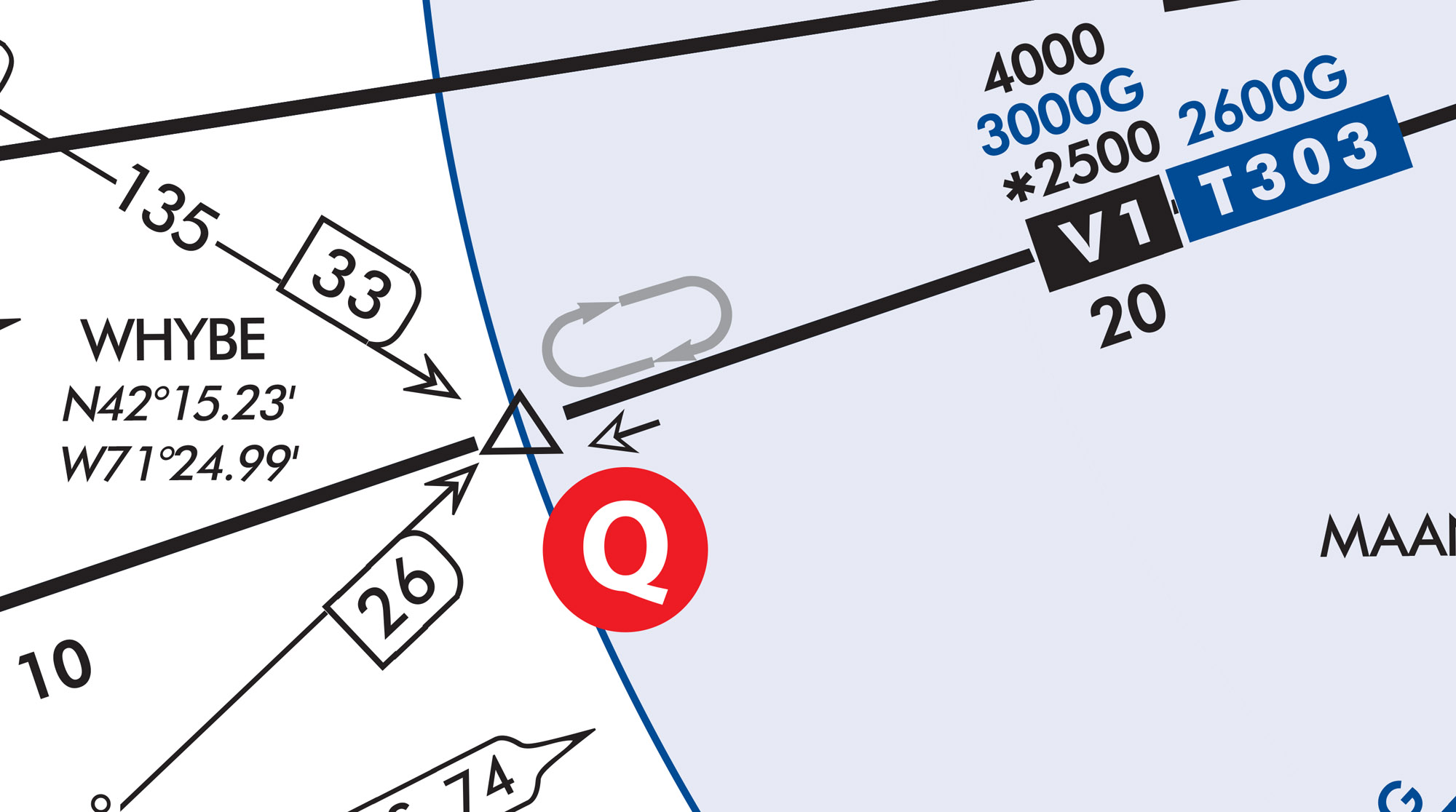
Deviating from the approach chart, WHYBE is also an en-route fix on a hybrid airway (V1 and T303) anchored to the northeast by the BOS VOR-DME. (Source: FAA IFR Low Altitude Enroute Chart L-33) It has a charted hold at WHYBE. Let’s look at the altitudes along the hybrid airway near WHYBE. 

Above the “V1” label (Q) there are familiar altitude displays. 4000 is the MEA in feet MSL using VOR navigation, *2500—the asterisk indicates that it is the VOR-based MOCA. However, if flying V1 using GPS, the MEA is 3000G feet MSL. But there is more. Right next and above the T303 label, the MEA is 2600G feet MSL when on T303. 

I reached out to the FAA regarding this paradoxical discrepancy, and this was their response: “V1 was established before T303, and at some point, there was likely a need for V1 to be inclusive of GNSS (aka GPS-LB) navigation before a T303 had been established. A GNSS MEA was established on V1 to provide GNSS navigation in that segment. The GNSS MEA established with T303 is more current than the one based on V1. An aircraft with GNSS capability should utilize T303-associated altitudes, effectively rendering the GNSS MEA on V1 moot.”

This clarification of the altitudes ensures that pilots understand the altitude requirements for different navigation equipment.

Separately, I also asked if T-Routes have MOCAs. The answer is not usually, but sometimes. If you look at low-altitude chart L-33 on T303 southwest of WHYBE between GRIPE and GRAYM, (R) the GPS MEA remains 2800G feet MSL, but there’s a GPS MOCA of *2300 feet MSL. When there is no MOCA the MEA acts as a de facto MOCA as there is no lower altitude than the MEA to keep aircraft away from the rocks. Typically, for VOR navigation, a MOCA allows receiving VOR signals within 22 NM of the station—irrelevant to T-Routes.

RNAV (GPS) RWY 35

The only other approach to Norwood is the RNAV (GPS) 35 approach, which has several advantages over the LOC 35 approach, especially with a WAAS-capable navigator. Assuming a WAAS GPS, the final approach segments have glide paths (LPV and LNAV/VNAV); the LPV even has a lower DA of 344 feet MSL (a) compared to a DA of 594 feet MSL (b) for the LNAV/VNAV. Notice that the LNAV MDA is slightly lower (580 feet MSL) compared to the LNAV/VNAV DA (c) . (This occasionally happens due to the different obstacle evaluation areas of the two approach types.) Compared to the LOC 35, LNAV/VNAV, and LNAV mins, flying to LPV mins wins over the other options.

I consider this approach a “modified T approach” since it has one “arm” DODNE (d) (IAF) five NM to CURLI (e) (IF), which is perpendicular to the intermediate segment. However, it does not say NoPT (no procedure turn) because no procedure turn is charted, and CURLI is a fly-by waypoint, implying that a procedure turn is unnecessary. Based on groundspeed, the navigator should indicate turn anticipation—the time to start turning to intercept the intermediate segment without overflying CURLI. The other IAF located at BURDY (f) is charted with a triangle, indicating that it is a low-altitude en-route VOR fix on V139-268, 22 NM BOS VOR-DME.

The missed approach holding fix (WHYBE) (g) is also charted as a triangle and, as previously discussed, is also an en-route low-altitude fix. However, it shows four-NM legs, typical of GPS holds. 


Luca F Bencini-Tibo finds it humorous in keeping with the retro theme that CURLI (the stage name of Curly Howard) of the original Three Stooges fame (STOGE) makes an appearance, “nyuk-nyuk-nyuk!”

Ready to Sell Your Aircraft?

List your airplane on AircraftForSale.com and reach qualified buyers.

List Your Aircraft
AircraftForSale Logo | FLYING Logo
Pilot in aircraft
Sign-up for newsletters & special offers!

Get the latest stories & special offers delivered directly to your inbox.

SUBSCRIBE