













Martin State

Long a favorite of instructors and examiners alike, it’s time we dug into this unusual and seemingly one-off approach, at least to broaden your understanding.

Gemini Sparkle

Key Takeaways:

  • Garmin GTN navigators are capable of flying DME arcs, despite a specific VOR/DME RWY 15 approach at Martin State (KMTN) not being pre-loaded in their database.
  • The KMTN VOR/DME RWY 15 approach, which uniquely features DME arcs for all its segments (initial, intermediate, final, and missed), cannot be coded into navigation databases because its final approach segment does not comply with ARINC-424 leg type requirements for PBN procedures.
  • Pilots can still fly the uncodable KMTN all-DME-arc approach manually using traditional VOR/DME, or by employing GPS for distance and/or azimuth information with careful heading control, emphasizing the unique skills required for such procedures and awareness of local airport details like specific taxi light activation and hazards.
See a mistake? Contact us.

One highly knowledgeable and respected instrument instructor categorically stated that Garmin GTN navigators cannot fly DME arcs. He used the GTN simulator to prove his claim since the KMTN VOR or TACAN RWY 15 approach (Martin State Airport in Maryland) isn’t in the database. I confirmed with Garmin that he was partially correct; the approach is not in the database. The reason it is not in the database is a bit convoluted. But his conclusion was not correct. The GTN Pilot’s Guide states, “The unit supports approaches containing DME arcs.”

Usually, I’m leery of absolutes like “never” and “always.” As in mathematics, it only takes one exception to prove the opposite. Also, we must be careful not to use inductive reasoning to reach broader conclusions from scant data. I have flown several approaches with DME arcs in the GTN databases. But what’s up with Martin State?


Airport History

The airport was the home of the Glenn L. Martin Company (today part of Lockheed Martin) during the 1920s and 1960s. During WWII, the company produced many airplane types, including the B26 Marauder twin-engine bomber (5288 units) and the PBM Mariner flying boat (1366 units). The Martin 2-0-2 and Martin 4-0-4 twin-engine piston airliners were built after WWII. Old seaplane ramps are located at the southeast corner of the field. The airport also houses the Glenn L. Martin Maryland Aviation Museum. 

Closer Look

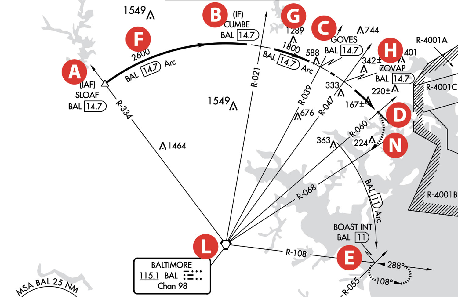
This approach is unique in that the initial (SLOAF A to CUMBRE B), intermediate (CUMBRE to GOVES C, which is also the final approach fix), final approach (GOVES to MAP D missed approach point), and missed approach (MAP to BOAST E) segments are all DME arcs. 

The initial approach segment is flown at 2600 feet MSL F, the intermediate segment at 1800 feet MSL G and the final segment is flown to the MDA of 920 feet MSL for all aircraft categories. However, a step-down fix (ZOVOP) at 1260 feet MSL H after GOVES is probably due to a nearby obstacle.

Flying the Approach

Why would anyone want to fly this approach when a perfectly good RNAV (GPS) RWY 15 is available with an almost straight-in track? Assuming a WAAS GPS, the MDA using LP mins is 500 feet I compared to 920 feet J for the VOR approach. A difference of 420 feet! Probably the best answer is “Because it is there!” This reminds me of pilots doing touch and goes at JFK, Newark, and La Guardia at 3:00 AM during the COVID months. The approach requires different skills, especially since DME arcs and VORs are disappearing. As a side comment, the GPS approach could have had an LPV minimum, but a course change from 142 degrees to 146 at the FAF (ODORS K) prevents having an LPV DA.

We have established that we cannot fly the approach by loading it in a GTN navigator or any other GPS navigator simply because it is not in the database. It is a VOR approach that requires DME. If we have a working DME, then we would use VOR for azimuth guidance and DME for distance. The VOR would indicate on a CDI (Course Deviation Indicator) the radial we are on and provide guidance on when to descend. But we don’t follow the CDI for track guidance as we would during a straight-in VOR, ILS, or RNAV approach. To stay on course while flying a DME arc, we fly headings—a little more to the right or a bit more to the left to maintain the required distance of 14.7 NM from the Baltimore VORTAC (BAL) L as we fly tangential segments. Both VOR and DME would be tuned to BAL.

If we don’t have DME, can we still fly this approach? Yes, if we have GPS and a current database. AC90-108 CHG 1 allows using a suitable RNAV system like GPS to “fly an arc based upon DME.” We can use VOR for azimuth information and GPS for distance. Or we can use GPS to provide both azimuth and distance information from BAL. 

If using VOR, BAL VORTAC must be tuned to the VOR frequency of 115.1 MHz. We constantly update the OBS setting to reflect the current radial as we fly along the arc. The best option is to use the VOR with a FROM flag so it is easier to follow the charted radials along the arc. We would also select BAL as a GPS waypoint in the flight plan and select DIRECT TO BAL. While not flying to BAL, it would show the distance. GPS should be set to OBS mode and waypoint sequencing would be suspended.

There is an easier way. With GPS and an EHSI, such as on most EFIS, we could use a bearing pointer for azimuth and distance information using BAL as our waypoint. BAL needs to be the active waypoint in the flight plan. Just like a traditional ADF needle on an RMI (Radio Magnetic Indicator), the pointer always points to the waypoint and the “tail” of the bearing pointer indicates the current radial from BAL.

In either case, remember we are flying headings manually or with an autopilot. Usually, the tolerance on a DME arc is one NM to either side of the center line, but that’s not really good enough on this procedure. If we are one NM off at the MAP, we’re one NM abeam the runway threshold—time for a missed approach. Also, we must be aware that the height of 898 feet AGL M at the MAP would not allow us to land on the runway. The bottom line is that we need to be centered on the arc near the MAP, and the runway should be visible, maybe a mile before the MAP, to allow for a normal descent. The visibility minimum is 1¼ SM.

The missed approach requires an immediate climbing turn, N which is perhaps why the MDH (Minimum Descent Height) is 898 feet AGL. Starting a climbing turn from a low height is not a good idea. Intercept the BAL 068 radial until 11 NM, then another 90-degree turn onto the 11 DME arc to BOAST E on BAL 108-degree radial. At BOAST, we can use GPS to hold. If the navigator does not allow the creation of a hold, we fly it in GPS OBS mode with BOAST as the holding waypoint. 

The GTNs allow the creation of a holding pattern inserted into the flight plan by specifying the holding criteria. While this hold is located on a VOR radial, the leg types are timed legs, usually one minute. However, holds using GPS typically have 4 NM legs. The approach chart doesn’t show a holding distance, so the hold is based on the standard one-minute inbound leg. If you’d prefer to fly distance legs—perhaps somewhat easier—you’ll need ATC approval.

Approach Is Not “Codeable”

The approach is not a PBN (Performance Based Navigation) procedure, but to be coded in the database, the legs must comply with ARINC-424 legs. Per the Instrument Procedures Manual “There are currently 23 different leg types, or path and terminators, that have been created in the ARINC 424 standard that enables RNAV systems to follow the complex paths that make up instrument departures, arrivals, and approaches. They describe to navigation avionics a path to be followed and the criteria that must be met before the path concludes and the next path begins.” The only three leg types allowed for the final approach segment are TF (tracking between two fixes), RF (radius to a fix), and CF (course to a fix). The DME arc of the final approach segment does not meet any of the three. 

George P. Shanks’s article “ARINC 424 Leg Types” (IFR Magazine, February 2015) covered this topic in greater detail.

Runway Length

The airport sketch O lists the runway length as 6997 feet, but a note P indicates that it is 8100 feet for military operations only. 

From a Google Earth perspective, the 1103 feet of pavement not available for civilian operations is not painted as a stopway or a displaced threshold. The most conservative interpretation for civilian operations is that it is a stopway.

Special Flight Rules Area 

“The Washington D.C. Metropolitan Area Special Flight Rules Area (DC SFRA) is roughly a circular area with a 30 nautical mile radius around Washington, D.C., and surrounds the Flight-Restricted Zone (FRZ).” While the approach to Martin State is outside the Washington DC SFRA, it is a good idea for pilots unfamiliar with the SFRA to take a required course when flying inside the SFRA. “Successful completion of this course fulfills the regulatory requirement for special awareness training on the Washington DC Special Flight Rules Area (SFRA) for pilots flying under VFR within 60 nm of the DCA VOR/DME.” The regulatory requirement is relevant not only for VFR but also for IFR. The course is on the FAASAFETY website (the WINGS PROGRAM). https://www.faasafety.gov/gslac/ALC/courseLanding.aspx?cID=405 

Taxi Lights

As is typical at many airports, when the tower is closed at Martin State, runway lights (REIL-runway end identification lights and HIRL-high intensity runway lights) are activated on the CTAF frequency 121.3 MHz. What is unusual is that the Airport/Facility Directory also states that the activation of Taxiway F lights (parallel to RWY 15/33 and to the south) can be done by clicking the microphone on the Unicom frequency 122.95 MHz and not on the CTAF 121.3. It pays to read the fine print; landing at night with runway lights on, but turning off to an unlit taxiway could be confusing or even dangerous.

Boats and Birds

Although the FAA charts don’t mention it, other sources warn that “Recreational sailboat masts to +50 feet and motor boats in waterways approach end of RWY 33, 813 feet from the threshold.” Additionally, “Seagulls on and in the vicinity of the airport.” I’m sure running into a boat or seagulls on short final would tend to spoil the day. 


Luca F Bencini-Tibo believes that flying non-traditional approach procedures is a great mental exercise for keeping ahead of the airplane. Still, they should first be first flown in VMC, especially if boat traffic might exist on a short final.

Ready to Sell Your Aircraft?

List your airplane on AircraftForSale.com and reach qualified buyers.

List Your Aircraft
AircraftForSale Logo | FLYING Logo
Pilot in aircraft
Sign-up for newsletters & special offers!

Get the latest stories & special offers delivered directly to your inbox.

SUBSCRIBE