Single-Engine Risks

While few of us feel that flying a single is particularly risky, add night and then add mountains and the risk is clearly higher. Add IMC and, well ...

Gemini Sparkle

Key Takeaways:

  • Operating single-engine aircraft at night or over hilly terrain significantly increases the risk of fatal accidents, being 2.2 times higher at night and resulting in a higher fatality rate over challenging topography.
  • In the event of an engine failure, pilots should evaluate emergency landing options beyond just the nearest airport, considering highways/roads (which have favorable survival statistics) or open fields (potentially aided by EFB satellite imagery or synthetic vision).
  • Key mitigation strategies include maintaining higher altitudes for extended glide time and decision-making, continuously assessing glide range to suitable landing sites, adhering to stricter weather minimums for night flights, and utilizing onboard technology like EFBs and Smart Glide.
See a mistake? Contact us.

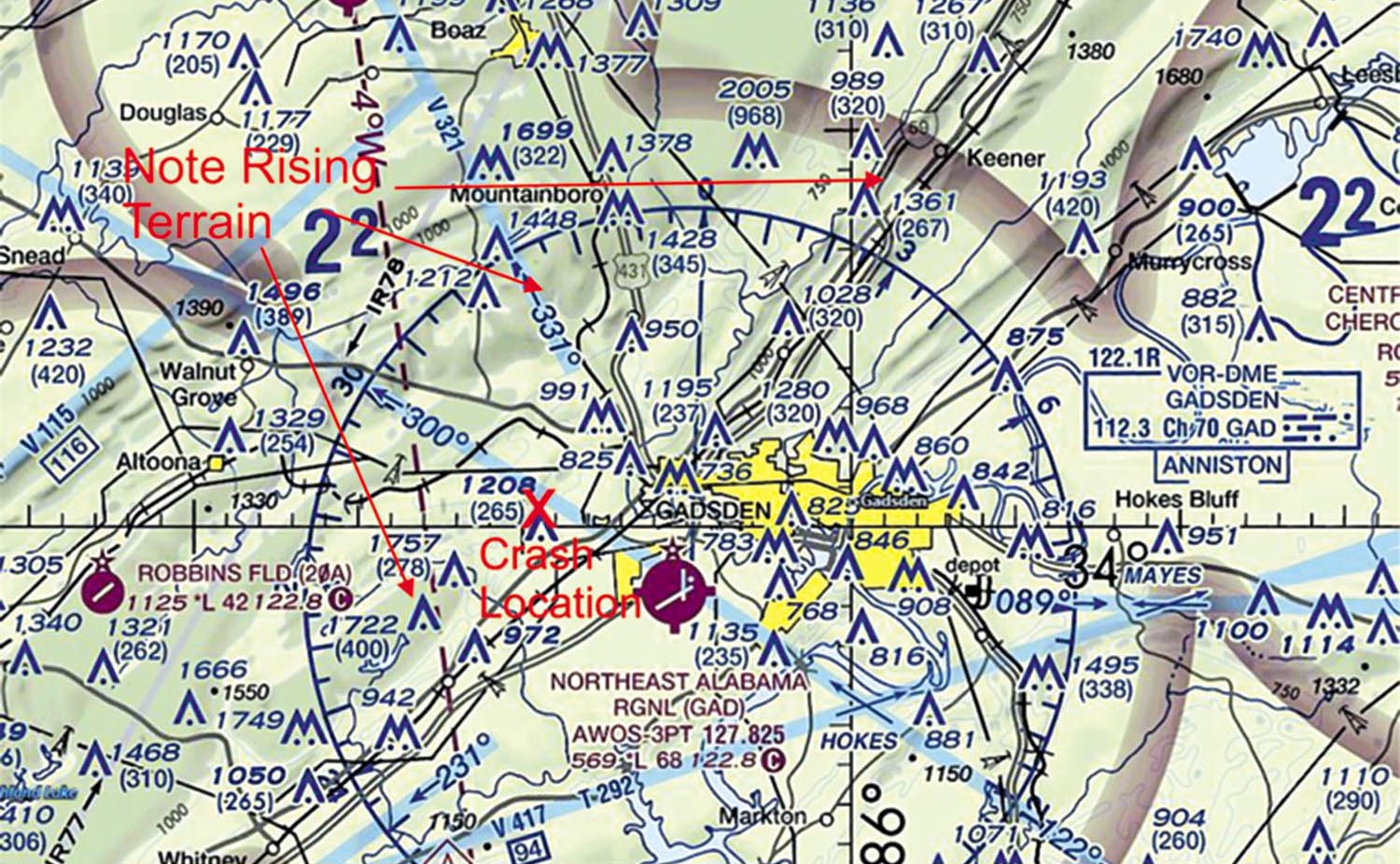
Poring over accident reports is my mainstay as an aviation-safety researcher and after many years I’ve developed a thick skin about most accidents I research. However, a recent fatal accident (November 2023—NTSB ERA24FA050) involving a turbocharged Piper Saratoga (N4187Q) on an IFR flight plan between Scott Municipal Airport (KSCX) in Tennessee and HL Sonny Callahan Airport (KCQF) in Alabama struck close to home.

The pilot had been a member of our flying club and I had flown his leased-back Saratoga TC on multiple occasions. Although the final NTSB report has yet to be published, I want to explore two of the operational risk factors applicable to the accident flight, namely night and hilly terrain. I’ll dive into published research on the level of risk we assume when operating a single-engine airplane under these conditions. I’ll also explore how we can mitigate such risks. 

How Risky Is It? 

Night flying is a classic good-news, bad-news story. The good news is that it’s generally much smoother and (with apologies to The Who), “I can see for miles.” Of course, the bad news is the risk of an engine failure—where do you put it down so you can walk away? I’m reminded of that old joke about the use of your landing light at night after an engine failure in a single. You wait until you’re close to the ground and turn on the light. If you like what you see, leave it on and land. If you don’t like what you see, turn it off. 

Let’s start by quantifying the risk of night flying and/or traversing rising terrain. Johns Hopkins researchers posed this very question and calculated that a risk of incurring an accident with a fatal outcome was 2.2 times higher at night than during the day. 

What about flights traversing rising terrain? In comparing accidents occurring in the Rockies/Appalachia with those over the Great Plains, other researchers found that 39 percent and 19 percent respectively of such mishaps were fatal. These stats drive the point home as to challenging environments. 

So, how can we minimize the risk? Let’s delve into how we can stack the odds in our favor. We’ll use the accident flight for illustrative purposes. 

Nearest Airport?

Many of us assume that diverting to the nearest airport is the best option and per aircraft performance and ADS-B data, N4187Q was within glide range of KGAD (next page). Indeed, we’re spring-loaded from recurrent training to punch the “NRST” button after establishing best glide. But is this always the best option at night? As to the N4187Q accident ATC advised that the KGAD runway 6/24 was closed and the short runway 18/36 did not have runway lights. Still, this might have been a viable option—airports with more than one runway typically provide a large amount of flat land. 

Longitudinal energy dissipation, once we contact terra firma, is key to surviving a power-loss mishap. Conversely, pilots might want to ponder whether landing at a smaller aerodrome with less acreage is a safe option. There are a bunch of factors to consider—trees/obstacles at the approach end, runway length with little time to consult the airport facility directory. Chances are you won’t have any glide slope guidance so you might be landing short because of “black hole” illusions we are prone to at night (FAA-H-0883-3C). Also, regardless of airport size, will you find the airport/beacon especially if bathed by surrounding city lights? 

Non-Runway Pavement?

But what about non-airport paved surfaces i.e. highways/roads/streets? A prominent highway lay between N4187Q and KGAD that was well within glide range. Alas, ATC only belatedly (when the aircraft was below 2000 feet AGL) advised the pilot of this option and, at that point, it might have been too late. Although squeezing between cars can be tricky, highways can be visibly prominent at night (below). That said, a distinction should be made between major (e.g. highways) and minor roads. The latter might be too narrow for obstacle clearance and/or possibly lack illumination, rendering them difficult to see. Another concern is the greater possibility of utility lines traversing minor roads—a collision could result in a stall due to failure of a lifting surface or a dramatic reduction in airspeed. Chances are you won’t see these lines either until just prior to getting “hung up.” 

Still, the statistics bode well for a road/street/highway landing. Querying the NTSB accident database for such mishaps (1982-present) yielded 54 such events (albeit mostly during daylight) with only two fatal. In fact, the non-fatal mishap count is probably even more favorable as events in which the aircraft was not substantially damaged and/or a person did not suffer a serious/fatal injury do not require reporting (49CFR 830).

Open Field? 

A third option following a power failure would be dead-sticking to relatively flat terrain within glide range. But that’s easier said than done with a less than enticing pitch black area providing little clue as to what lurks below. But new technology could help. Specifically, EFB aerial map views (VFR sectional and IFR charts disabled) comprising satellite imagery could provide guidance as to a field free of man-made obstructions, as could synthetic vision available in some EFIS. 

Keep in mind that outdated imagery or insufficient image resolution could prevent recognizing hazards such as a ditch. Remember, dissipating the energy in the landing roll is key to surviving a power-loss event. One downside of employing farmer John’s field is that rescue personnel will likely take longer to reach you than should you elect a thoroughfare or, better, an airport.

Other Considerations

I discussed glide range using Saratoga POH-derived flight parameters and aircraft altitude AGL. EFBs and, indeed, Garmin’s Smart Glide feature can depict that distance as a green circle that is centered on your aircraft but you must configure the system with your airplane performance parameters. My experiment showed that numerous potential landing sites were available, including highways.

An aviation mantra that altitude is the pilot’s best friend (barring a fire) applies to these risky flight environments. Select an altitude high enough to allow for one of the listed options but remember the need for supplemental oxygen especially at night where disorientation and visual acuity degradation manifest as low as 4000 feet (FAA-H-8083-25B). The accident aircraft was so equipped but based on its relatively low altitude (6000 feet MSL, 5500 feet AGL) it’s unlikely the pilot availed himself of this option. Would it have mattered? Maybe; maybe not. But certainly it would have given him more time to consider his options.

What about safe practices when operating a single-engine aircraft over rising terrain? A 2022 Embry Riddle research study found that two-thirds of single-engine aircraft traversing mountainous terrain were at altitudes that were beyond gliding distance of flat terrain. Consider borrowing from practices mandatory for our airline cousins. Yup, these guys have to plan for an engine-out scenario such that their minimum en-route altitude allows for a “drift down” to their single engine service ceiling (14CFR §121.191) with a path that avoids convergence with granite. 

Regardless of underlying terrain, regularly refresh your landing options by remaining within gliding distance of one of the options as the flight progresses. Who knows when the engine will select stealth mode? Anecdotally, I find ATC to be extremely cooperative often allowing me to stay within gliding distance of one of the discussed landing options and/or maintain a higher altitude as long as practical on my IFR night flights.

Weather

For night flights, consider a minimum of 1500-foot ceiling and a visibility of at least three SM across the route as giving sufficient altitude and time to visually acquire a lighted highway, airport beacon etc. Also, data-linked weather is not onboard radar and I nix any night flight for which convection is forecast, subscribing to the regs (§121.357) for our heavy-iron siblings with an inop radar. 

Wrapping Up

Undoubtedly, operating a single-engine aircraft in these challenging environments ramps up the chances of an early obituary. That said, while adherence to some of the recommendations we’ve discussed won’t eliminate the risk, they can at least offset it somewhat. Also, consider loading up the right seat with a pilot pal who can constantly scan for suitable areas for putting the aircraft down as you fly. 


Douglas Boyd equates night flying with another activity of a long-established nocturnal profession—better to invoke safe practices early than be sorry later.

Ready to Sell Your Aircraft?

List your airplane on AircraftForSale.com and reach qualified buyers.

List Your Aircraft
AircraftForSale Logo | FLYING Logo
Pilot in aircraft
Sign-up for newsletters & special offers!

Get the latest stories & special offers delivered directly to your inbox.

SUBSCRIBE