ADS-B Shenanigans?

Thank you for printing in Augusts magazine the short letter I wrote, highlighting an issue I encountered just south of the Albany, N.Y., Class C airspace-a Cub showing an ADS-B altitude of 500 feet below sea level. (By the way, I passed the same Cub today at very close range. This time he wasnt showing up at all on ADS-B). In your response, you asked readers to report other anomalies, so heres one from a week or so ago.

Gemini Sparkle

Key Takeaways:

  • A pilot reported a second instance of highly erroneous ADS-B data (a jet showing >1000 knots groundspeed) near the same location where he previously observed a negative altitude reading, prompting speculation about ground station issues.
  • The publication is actively seeking reports and screenshots from readers who have experienced similar "ADS-B shenanigans" or erroneous traffic data, particularly concerning TIS-B.
  • An app developer explained how his free "POH Performance" apps calculate adjusted takeoff and landing distances for sloped runways, using historical aerospace research, and incorporate safety margins.
See a mistake? Contact us.

Thank you for printing in August’s magazine the short letter I wrote, highlighting an issue I encountered just south of the Albany, N.Y., Class C airspace—a Cub showing an ADS-B altitude of 500 feet below sea level. (By the way, I passed the same Cub today at very close range. This time he wasn’t showing up at all on ADS-B). In your response, you asked readers to report other anomalies, so here’s one from a week or so ago.

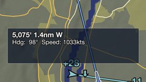
I was in nearly the exact same location as I was for the prior report when my ADS-B In/Out transceiver, a Garmin GTX 345, highlighted an aircraft passing low overhead at a speed of 1033 knots. I eagerly acquired it visually, assuming it was a UFO. (There has been a spike in UFO sightings recently—I was hoping to report the first one with ADS-B compliance!)

Sadly, the “streaker” was a generic bizjet, likely bound for nearby KPSF. Interestingly, for as long as I received data from this aircraft, its ADS-B-reported groundspeed remained above 1000 knots.

Is it interesting, or just a coincidence, that my location was almost precisely the same as where I had the issue of the “Cub Yellow Submarine” a few weeks prior? I don’t know enough about the intricacies of the ADS B system, but could the problem not lie with the aircraft reporting altitude and speed but with the interpretation of its data by the nearby ground station?

Daniel Spitzer, M.D.
Via email

Thanks for also sharing the screenshot of your iPad-based electronic flight bag displaying the ADS-B target’s groundspeed, which is reproduced below. We just work here, but we’d guess the problem resides with the ground station near you. That said, and as we wrote in August, we’re very interested in hearing from other readers who have experienced what we call ADS-B shenanigans—erroneous traffic data, or targets disappearing and reappearing, for example—when it comes to the TIS-B traffic information service available via ADS-B In. “Screenshots or it didn’t happen,” as the kids say.

There’s An App For That

Regarding Mike Hart’s “Downhill Or Downwind” article in the August 2019 issue, I’ve wondered the same thing myself. In researching this, I came across material on the EAA Chapter 1000 web site based on a 1966 technical report from the U.S. Air Force Flight Test Center at Edwards AFB. The sidebar on the effect of slope for takeoff in the article gets it mostly right. The key difference is that the result is a function of rotation speed (VR ).

1033knotsgroundspeed

The main idea is that the POH publishes a distance to takeoff distance to achieve VR . If you assume constant acceleration, then you can compute the positive or negative effect of slope on the takeoff acceleration and therefore calculate the new distance. There’s a math formula using radians for the slope angle, gravity’s acceleration of 32.2 feet/sec/sec and VR expressed in feet per second.

I’m also the main author of the POH Performance series of apps: Baron Performance, Bonanza Performance, C172 Performance, and TBM Performance (Seepohperformance.com). The apps use the formula to adjust the takeoff distance for sloped runways. The only modification is that the apps don’t reduce takeoff distance for downslope takeoffs to keep the numbers more conservative than the POH.

For a given airport and set of weight, wind and temperature conditions, the app calculates the takeoff distances for all available runways and chooses the best assuming a variety of safety criteria (long enough runway with safety factor, below max crosswind, etc.). You can manually select another runway as well. The apps also use the takeoff slope adjustment formula to calculate the “Upslope takeoff minimum headwind,” if the selected runway has a slope. They do this by repeatedly computing the POH takeoff distance for the conditions assuming upslope headwinds from 1 to 10 knots, then finding the headwind at which taking off upslope is less distance than taking off downslope.

The only authoritative reference I could find on how landing distances are affected by slope was a 2006 document published in the U.K. Its data also is incorporated into the apps. The apps are free and the source code is published.

Steve Kleiman
Via email

Ready to Sell Your Aircraft?

List your airplane on AircraftForSale.com and reach qualified buyers.

List Your Aircraft
AircraftForSale Logo | FLYING Logo
Pilot in aircraft
Sign-up for newsletters & special offers!

Get the latest stories & special offers delivered directly to your inbox.

SUBSCRIBE