













Register

Old Vs. New ILS

Gemini Sparkle

Key Takeaways:

  • The article highlights the increasing appearance of ILS approaches, like the "ILS Y" at KTTA, that incorporate Terminal Arrival Areas (TAAs), a feature traditionally associated with RNAV (GPS) procedures.
  • TAAs replace Minimum Sector Altitudes (MSAs) and offer operationally usable, obstacle-clearing altitudes (like large MEAs) for approach entry, often simplifying pilot navigation by allowing direct-to-IAF clearances using required GPS.
  • These combined ILS/TAA procedures frequently mandate GPS or radar for entry and specifically require RNAV 1-GPS for identifying crucial fixes in the final segment and for the missed approach.
  • The shift towards ILS approaches with TAAs is partly attributed to the widespread use of WAAS GPS in general aviation and the ongoing decommissioning of VORs as part of the Minimum Operational Network (MON) program.
See a mistake? Contact us.

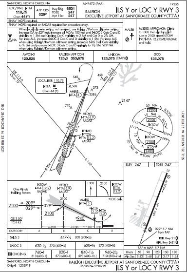
When I first saw the approach chart for the ILS Y or LOC Y RWY 3 at Raleigh Executive Jetport at Sanford-Lee County, South Carolina (KTTA), I thought I was seeing something unusual. I was. It’s an ILS approach with a Terminal Arrival Area (TAA). Yes, these are possible and we’re starting to see more, so let’s take a closer look. Let’s call this the “Y” approach. The “Y” also implies that there is a “Z” approach lurking nearby.

TAAs and MSAs

TAAs are typically associated with RNAV (GPS) approaches using the familiar “T” structure. Such designs frequently have initial approach fixes (IAF) at the end of the arms of the “T” and the center waypoint is usually an IAF and an intermediate fix (IF). However not all GPS “T” approaches have TAAs.


Ready to Sell Your Aircraft?

List your airplane on AircraftForSale.com and reach qualified buyers.

List Your Aircraft
AircraftForSale Logo | FLYING Logo
Pilot in aircraft
Sign-up for newsletters & special offers!

Get the latest stories & special offers delivered directly to your inbox.

SUBSCRIBE