Register

How Do You Interpret an Eddy Dissipation Rate?

EDR quantifies turbulence for a specific aircraft, and it’s not a measure of the likelihood of turbulence—just the intensity.

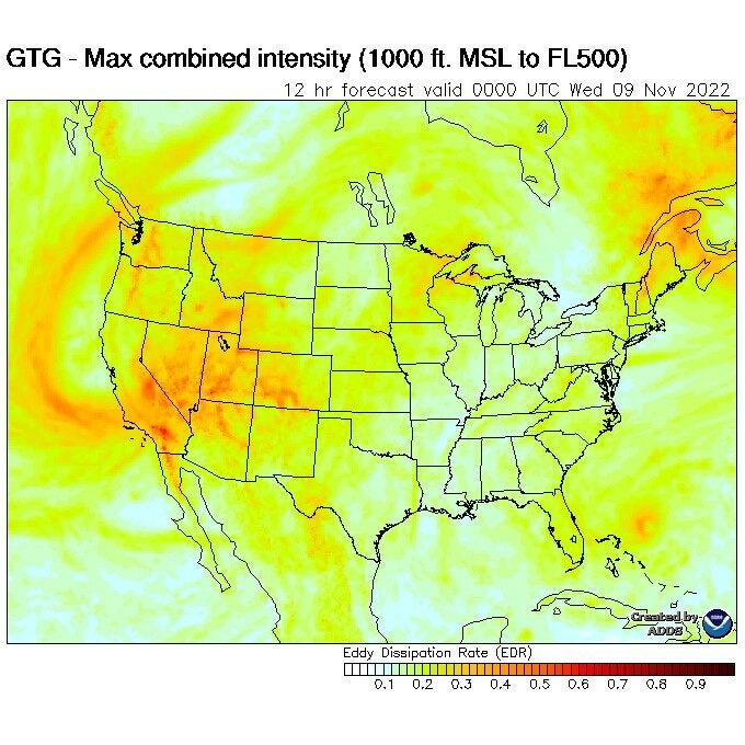
The contoured Graphic Turbulence Guidance (GTG) product at aviationweather.gov/turbulence depicts the eddy dissipation rate (EDR) forecast over the conterminous U.S., southern Canada, and Mexico. [Screenshot]
Gemini Sparkle

Key Takeaways:

  • Eddy Dissipation Rate (EDR) is an aircraft-independent meteorological field (m²/s³) that quantifies the *intensity* of atmospheric turbulence, measuring how rapidly atmospheric eddies dissipate.
  • EDR values range from 0 (smooth) to 1 (extreme turbulence), often scaled 0-100 for ease of use, with higher numbers indicating greater mixing and turbulence.
  • Critically, while EDR itself is aircraft-independent, its interpretation into felt turbulence categories (light, moderate, severe) is highly dependent on the aircraft's weight class, meaning the same EDR value can represent different turbulence levels for different aircraft.
  • Aviation tools like EZWxBrief utilize EDR to provide categorical turbulence forecasts, color-coding predicted conditions based on the pilot's specific aircraft weight class.
See a mistake? Contact us.

Question: Lately I’ve been hearing the term “eddy dissipation rate” used for turbulence forecasts. What is it and how should I interpret it?

Answer:

Scott Dennstaedt, Ph.D

Scott resides in Charlotte, North Carolina, and flies regularly throughout the Mid-Atlantic and Southeast U.S. He is a CFI and former NWS meteorologist. Scott is the author of "The Skew-T log (p) and Me: A Primer for Pilots" and the founder of EZWxBrief.

Ready to Sell Your Aircraft?

List your airplane on AircraftForSale.com and reach qualified buyers.

List Your Aircraft
AircraftForSale Logo | FLYING Logo
Pilot in aircraft
Sign-up for newsletters & special offers!

Get the latest stories & special offers delivered directly to your inbox.

SUBSCRIBE