The Real-Life Evolution of the Drone
Small unmanned aircraft systems, (sUAS) have become as much of a tool for companies and organizations as cellphones and laptops.
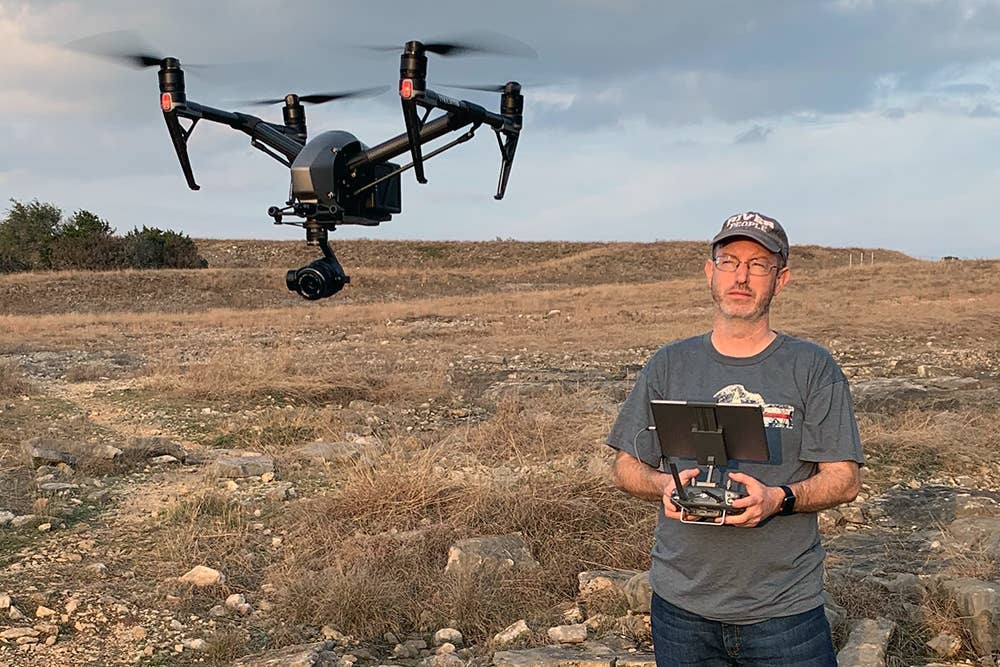
Justin Moore, owner/chief pilot, Airborne Aerial Photography in Texas, gets ready for an assignment. [Courtesy: Jason Moore]
In 2016, ground schools started popping up for small unmanned aircraft systems (sUAS), commonly referred to as “drones.”
Most of the learners would show up to these because they planned to use drones for their businesses, and it was understood that soon the FAA would be requiring a pilot certificate beyond the Section 333 Authorization for commercial operations.
Back then, drones were still regarded by many as toys strictly for amusement. How in the world could a toy be used in business?
How far the technology—and the culture of drones—has come.
Drones as a Marketing Tool
If a picture is worth a thousand words, there is something inherently valuable about images captured from a drone. The real estate industry was one of the first groups to realize this, and these days, it is difficult to find a realtor who is not using a drone for marketing purposes. Virtual tours of homes for sale often start with aerial views of the neighborhood.
"Before that, we went up in small aircraft or helicopters," says Scott Manthey, founder and CEO of Image Art Productions. The company specializes in commercial stills and video advertising primarily for real estate. His company has been using drones since 2015. Today, they have a fleet of sUAS and a cadre of Part 107 certificated remote pilots.
One of the benefits of using a drone, says Manthey, is that drones can go places that are inaccessible to humans.
"There have been a few times where the property we needed to shoot was partially wetlands and we needed to get images of the other side that were inaccessible by vehicle or foot, so we flew the drone over the wetlands."
One of the challenges of using drones in nature, says Manthey, is that sometimes nature attacks the device thinking it is a predator.
"Birds, especially seagulls and crows, will attack the drone in the spring," he says. "The seagulls even try to crap on it in flight. Sometimes, a bunch of bees will attack, causing carnage and the need to clean the drone. Once in a while, hummingbirds follow it around like they think it is a big version of them."
Drones in Environmentally Sensitive Areas
Drones are particularly useful when it comes to restoration of areas destroyed by wildfire. DroneSeed, a Seattle-based company established in 2016, was one of the first to take on the task.
These areas are often on steep slopes that when denuded, become unstable, leading to erosion and potential landslides. The burned areas can be dangerous to even hike up in order to replant them.
“Reforestation can be a time-consuming and difficult process when done by hand over rough terrain," says Grant Canary, DroneSeed CEO. The Seattle-based company is at the forefront of drone operations.
"Our company’s drones navigate and map difficult terrain, selecting specific spots…that are the most promising for trees to grow roots. We use custom ecosystem-specific seed vessels to maximize our establishment and survival rates. Combining cutting-edge drone seeding technology with tried and true seedling inter-planting in a second stage combines the advantages of each and is the best strategy towards ensuring the regrowth and long-term health of our forests."
DroneSeed was the first drone company to obtain FAA approval to fly multiple drones—known as a swarm—weighing more than 55 pounds beyond line of sight (BLOS).
In addition to replanting, drones are excellent tools to support wildlife studies, says Justin Moore, owner/chief pilot, Airborne Aerial Photography in Texas. Moore's company uses several drones, including a DJI Mavic 3 Cine drone, a DJI Inspire 2, and a DJI Phantom 4 Pro.
"We have used drones to cover prescribed burns of invasive species, and we’ve also taken photographs for geologists on cliff faces at a nature preserve that is inaccessible to humans,” Moore says. “We used drone mapping in a scientific study of Bigtooth maple trees that reduced the work of environmental scientists by 90 percent and was featured in a published scientific paper by the University of Texas."
Moore is a pilot of manned aircraft and a professional photographer covering events such as Sun 'n Fun Aerospace Expo and EAA AirVenture from the ground. He notes that not everyone loves the sound of large aircraft overhead, so the drones are very useful in covering events where a low-flying manned aircraft might be seen as intrusive, "such as a night kayaking event along the San Antonio River," Moore says. "We’ve also used #dronesforgood—conservation work with environmental scientists at local nature preserves utilizing drone mapping, and demos at local schools to encourage kids to pursue drones and aviation as a great career choice."
For the most part though, Moore says, the drones are used as a tool in support of the construction industry.
"We take monthly aerial photos and video of construction sites to help project supervisors see work progression, identify safety hazards, etc.," he explains.
Drones for Public Safety
Construction isn't the only industry that uses data gathered by drones to prevent harm. Drones are becoming increasingly important to public safety organizations as a means to mitigate risk to employees and improve department efficiency.
For example, a good deal of public safety work involves searches in remote areas. While it might take hours for someone on the ground to move through a semi-wilderness, a drone a hundred feet in the air can cover significantly more terrain in a shorter amount of time.
"We use the sUAS as overwatch during SWAT operations and critical incident management, K-9 tracking, accident reconstruction and modeling, crime scene documentation and photography, school emergency response planning, and law enforcement skills training enhancement,” says Corporal Blaine Davis, unmanned systems program coordinator of the Chesterfield County Police Department in Virginia. "Our UAS have been deployed inside of structures, attics, and crawl spaces with violent armed individuals who had discharged a firearm at officers or threatened violence towards others."
The drones are also used to acquire video during training exercises. The action is recorded and then the video is studied later so that learning can take place.
The department began to use drones in November 2020 with eight officers acting as remote pilots. Davis had a significant amount of aviation experience in manned aircraft before he took up the drone for law enforcement, but adds that it is not the case for many officers. To be part of the drone detachment, each officer has to take special training and gain a certain amount of experience before being allowed to fly the sUAS on department sanctioned missions.
"Everyone received their remote pilot certificate within three months of entering the program," Davis says. "Each operator then received four days of base training and four days of mission training and were required to obtain 40 hours of flight time prior to being utilized for law enforcement missions."
Common Drone Mistakes
All of the commercial drone operators interviewed for this piece had the same answer when asked what the biggest mistake is that wanna-be commercial drone pilots make—assuming that having a drone automatically meant they would have a steady supply of customers, often before they’ve even learned to operate the drone.
"There’s no practical test for remote pilots, so you can be one and have awful flying skills," says Moore, adding that learning to fly the drone before you need to be able to fly the drone is key.
"It is hard work to get clients," Manthey says. "A new sUAV pilot will almost always give away their services or sell them too low at first and that hurts their credibility. They also rarely understand where they can fly and what they need to do to fly safely [like contact the tower, or get the FAA exemption to fly in that area] and they create challenges for those of us who are following the rules and being safe."
Another common mistake, says Manthey, is the assumption that the drone needs to be hundreds of feet in the air to get the best video.
"The introduction of drone technology was a game changer for aerial photography."
Dave Kellman, director of photography, for Pierce County TV (PCTV) in Washington State.
"At least 50 percent of the images I take with the drone are under 50 feet and that is where it really shines as a platform. That is something you just can’t do any other way except renting a big cherry picker." he says.
Even for the experienced drone operator there are surprises, Moore notes.
"The most frustrating surprises are firmware updates from the drone maker that create problems or drama trying to unlock ‘geo fences’ around airports or sensitive sites where the FAA has already given us permission, but the drone maker isn’t making it easy to unlock the no-fly zone."
Sometimes, the drone operators find themselves dealing with the misconceptions of people who are not part of the drone mission. For example, there are some people who think it is within their rights to fire a gun at a drone in an attempt to shoot it down, not realizing that firing at an aircraft of any sort is a federal offense.
Sometimes people automatically think a drone is being used for no good. For example, a homeowner in Oregon who was using a drone to get video of the damage to his roof after a storm found himself talking to police officers because his home is near an elementary school and someone from the school thought he was taking video of the children at recess.
Drones for Media
"As a visual storyteller I am always looking for creative camera angles," says Dave Kellman, director of photography, for Pierce County TV (PCTV) in Washington State. “Four hundred feet up offers that unique perspective."
Kellman earned his Part 107 certificate from the FAA in 2017.
"The introduction of drone technology was a game changer for aerial photography. Before drones, we would film from a helicopter or small plane. Keeping the camera steady when shooting from an aircraft is challenging. You can't top the smooth and stable images a drone equipped with a three-axis motorized gimbal provides."
Kellman notes that drones have become "an industry standard for television and video production. A view from the sky is an excellent way to establish your scene. Flying over a city skyline or neighborhood is a great way to introduce a location."
"At PCTV, we have put our drones in plenty of situations not accessible by people. For example, we have used drones to cover flooding events and wildfires. I personally have put drones out over cliffs and hovered above rushing rivers."
There was a learning curve, he notes, "A few years ago, I lost a drone in a 70-foot waterfall. The aircraft couldn’t handle the high amount of wind shear. The drone is probably still there in the rocks behind the falls. It wouldn’t be safe to try and retrieve the aircraft. I wish I had the footage though!"

Subscribe to Our Newsletter
Get the latest FLYING stories delivered directly to your inbox

