
Pilots flying during the COVID-19 pandemic have an added layer of complexity to consider in their initial flight planning. This planning now needs to include the various travel restrictions on where to go and if to stay. Summer 2020 included much of this consideration when planning where to visit with my Piper Cherokee PA-28-180. If you were from New Jersey, then Maine was one of the few states you could go and not quarantine on either end of your stay. Making my decision easier was that a friend of mine was visiting Bar Harbor with his family. Spending a few days with them while working remotely during the day seemed like a good option. SiriusXM Satellite Weather couldn’t help with COVID-19 planning or precautions, but it did help me get home safely a few days later.
It was Wednesday afternoon, and the weather was predicted to remain pretty good over the next 24 hours along my route of flight from Bar Harbor, Maine (KBHB), to Greenwood Lake Airport, New Jersey (4N1). I have a regular meeting at work at 1 p.m. on Thursdays, which I prefer to take in my office in New Jersey. Admittedly, this meeting was an added “external pressure,” or “E” in the PAVE checklist. I asked myself if I would be taking the flight if it weren’t for the meeting; I concluded that I would be based on the information I had.
Other than an expected headwind, the weather was going to be flyable, so I decided to stay one more night with my friends in Maine and fly home in the morning. The headwinds were going to be a factor, so I knew that I needed to leave KBHB by 8 a.m. I figured that 8 a.m. was late enough in the morning to justify spending time that night to enjoy dinner and get a good night’s sleep. I wanted to make sure I was fully fit for flying on what could be a long flight home. Being current to fly in every requirement—the “P,” or “pilot,” in the PAVE checklist—was complete, and I was up for the flight.
I woke up the next morning and obtained a full standard weather brief from ForeFlight. The forecast had changed quite a bit. The ceilings were predicted to be lower than I thought, and I didn’t want to fly under visual flight rules (VFR) the entire way. This was mostly because the ceilings were low in some places along the route, and in the case that I needed to fly the instrument approach at Greenwood Lake, filing an instrument flight rules (IFR) flight plan was the best option for me. I reviewed all of the airports and forecasts along the route of flight, thought about alternates along the way, and selected an alternate for my arrival airport. I usually choose Morristown (KMMU) Airport as an alternate because it is still close to my house and there is an ILS approach there as well. This covered the “V,” or “enVironment,” in the PAVE checklist.
I filed an IFR flight plan about an hour and half before my scheduled departure from my hotel room in Bar Harbor. I showered, got in the car that my friends allowed me to use, and drove to the airport. My friends were going to pick up the car later that day, so I left the keys with the very kind people at KBHB’s Columbia Air Services. I had been in and out of that particular FBO quite a bit over the summer. When I said I was leaving for the season and likely wouldn’t be back for a while, they gave me a Columbia Aviation T-shirt. I thanked them for the T-shirt and all the help over the summer, and I walked out to the ramp to preflight the plane. I am especially grateful to brothers Ian and Austin, who work the flight line at Columbia. I dropped one of my favorite ball caps at the airport, and they sent it to me in the mail at my house in New Jersey. Outstanding service and kindness from Columbia.
After my preflight check was complete, everything checked out fine. I had full fuel, which is about five and a half hours total, or four and a half hours with IFR reserves, made up of a 15 minute flight to KMMU and 45 minutes longer. This is all part of the “A,” or “aircraft,” in the PAVE checklist. With my preflight checklist fully completed, I called Bangor Approach’s Clearance Delivery. They gave me the following full-route clearance:
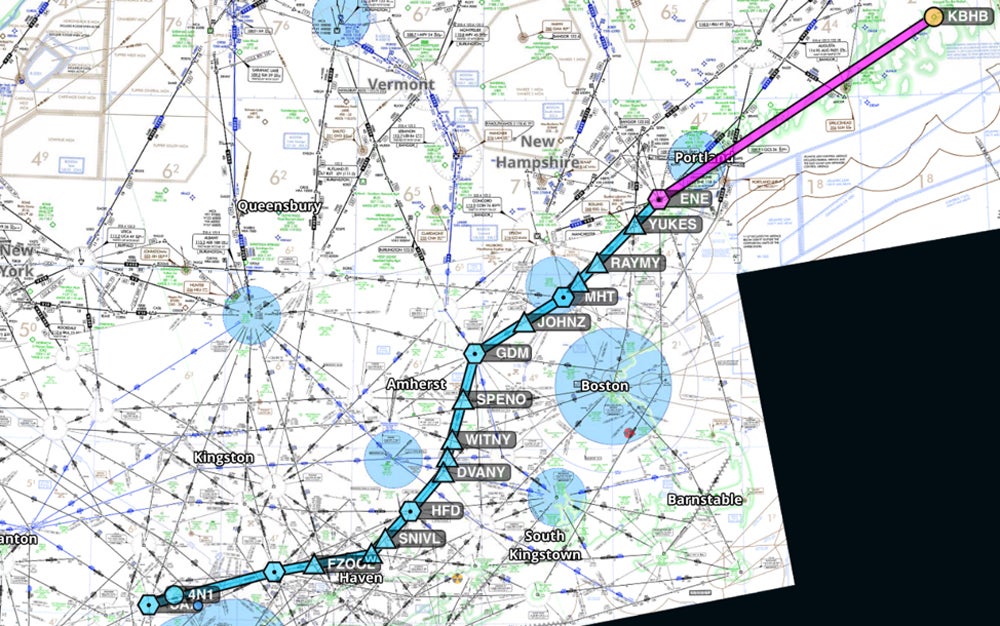
KBHB ENE V106 GDM V229 SEALL V188 CMK V39 SAX Direct 4N1
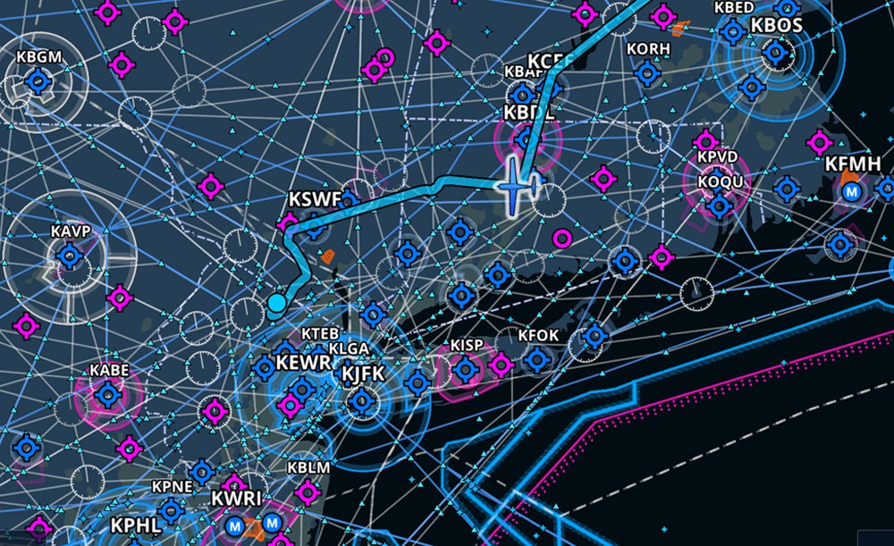
This original clearance issued by Bangor Approach brought me southwest, then west across the south shore of Connecticut. This can be seen here on the IFR (low) chart from ForeFlight.
It was approaching 8 a.m., and it was time to depart. Weather was getting worse south of my destination, with overcast and scattered clouds at various altitudes along the route of flight. I was happy that I had filed IFR so I could get through these en route cloud layers without much problem. There was precipitation on the radar to the southwest. I did notice a storm system developing and moving, but it appeared to be moving east-northeast, and it didn’t seem it would influence the flight. I suspected it would be past my destination and not impede the route I was flying by the time I was arriving to land.
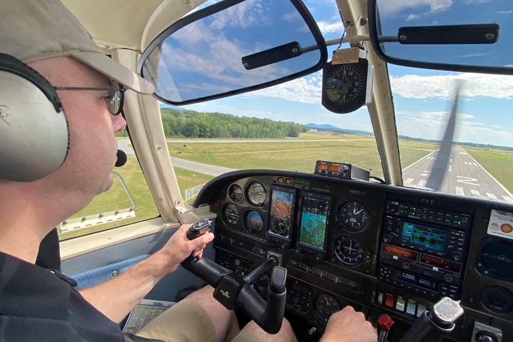
By the time I flew over Manchester (MHT) an hour and forty-five minutes later, I checked my onboard SiriusXM Satellite Weather, which is received by Garmin’s GDL 69 and displays on both the Garmin 430w and the Aspen MFD on the panel. The plane is also equipped with a WX-1000 Stormscope. This equipment is helpful when flying IFR, but none of it makes a Piper Cherokee move faster. You can see the panel of the plane in the picture below while arriving this summer on RWY22 at KBHB.

As Murphy’s Law would have it, the combination of the strong headwinds causing me to move very slowly (it is after all a PA-28-180) were the very same winds that were advancing the storms faster than I had expected. Seeing the precipitation activity on the screens, I asked Boston Center to amend my clearance from GDM to BAF PWL IGN, then direct WAMUV for the approach to 4N1.
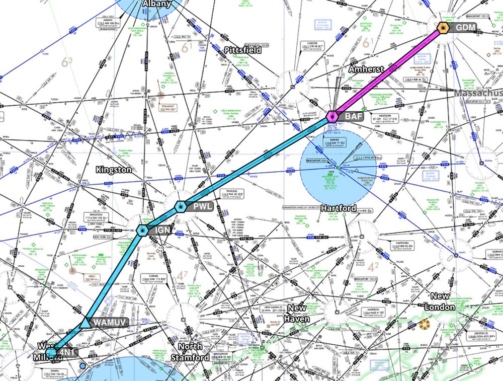
This would keep me at least 20 miles away and upwind of the storms.
Boston Center approved my request, and I flew on. I was feeling pretty good about the rest of the flight and exercising my pilot in command authority to request a better route for weather avoidance. I was switched to Bradley Approach, and they asked me to copy a “new clearance.” I copied the new clearance, which turned out to be the old clearance picking it up at SEALL. So much for that good feeling. SEALL is an intersection along V229, V188 and the southern end of V34. This is about 8 miles north of Tweed-New Haven (KHVN) Airport along the Connecticut coast, where it would predictably fly me into the foul weather.
Complying with the new clearance was fine until I was able to “trust but verify” and study the route a bit more closely. I updated Bradley Approach that I would be unable to continue to fly the cleared route and that SiriusXM Weather was showing moderate to high precipitation along the route they just gave me. It took them about 20 minutes to work out a new clearance with New York Approach.
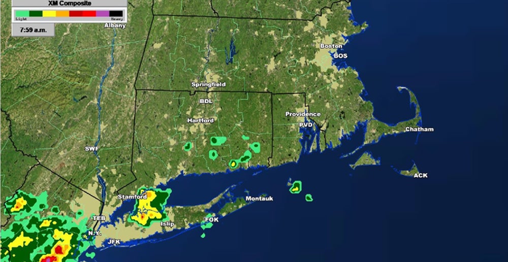
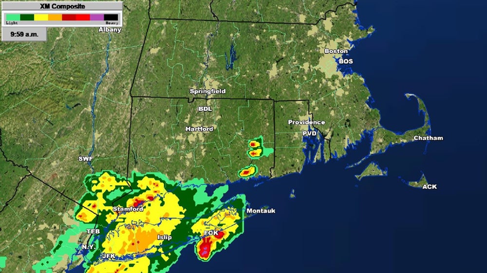
While studying the new clearance now over Gardner (GDM), below is what SiriusXM Weather was showing.
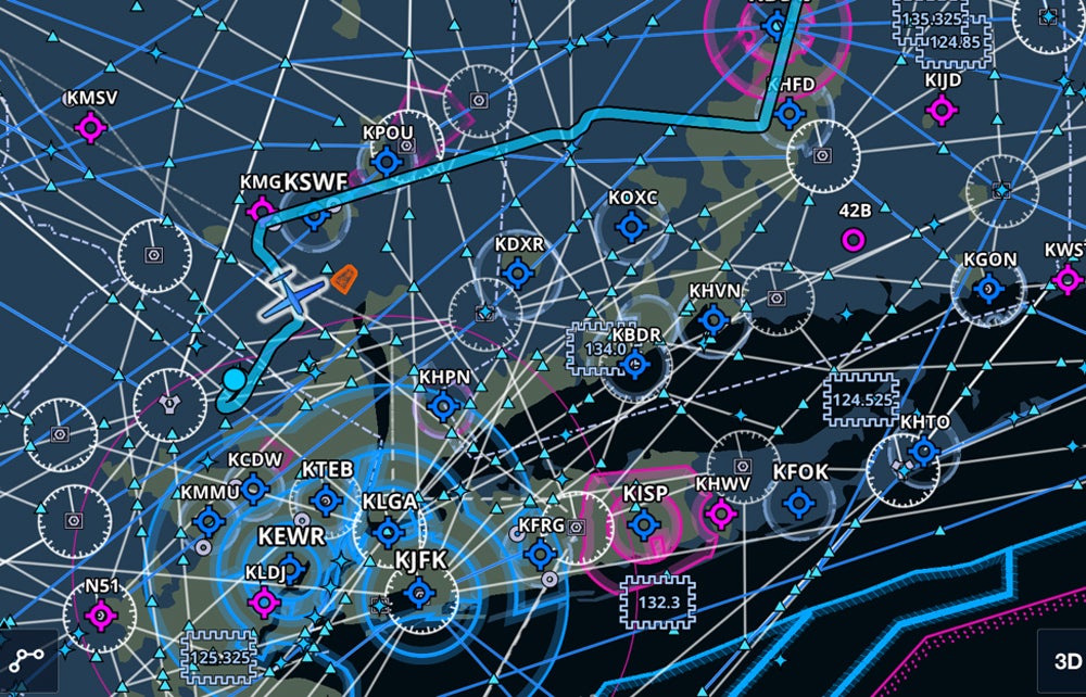
It wasn’t until I was nearly over Hartford (KHFD) Airport and only about 30 miles north of some real weather problems that I was able to turn west toward Pawling (PWL), then later cleared direct Huguenot (HUO). New York Approach was very busy, and it took a while to check in due to the radio traffic.
Direct HUO was very helpful before getting to PWL; it brought me clear of clouds west of Stewart Airport (KSWF), and the ceiling was well above me when I canceled IFR and flew the rest of the trip VFR without any further issues.
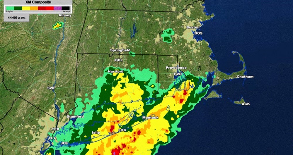
This flight’s circumstances proved SiriusXM Weather’s value to me while in the air on these long cross-country flights. It also emphasizes the importance exercising pilot-in-command authority, using the best information available, asking for what you need from ATC, all while flying the airplane single-pilot IFR. Specifically, drawing the controllers’ attention to what the same information the pilot is looking at in the plane, then discussing the information to understand why certain requests are being made. ATC was certainly more than accommodating during this four-hour flight. Below is the weather at noon when I landed. You can see the moderate precipitation along the segments of V229 that I would have been flying just an hour and a half earlier.
Without the advance information from SiriusXM Weather in the cockpit with me, I may have gotten close enough to these storms, where I likely would have had to land and wait out the rain. Instead, I was able to navigate safely, arrive at my intended airport of landing, put the plane away, and make my 1 p.m. meeting in the comfort of my office.
Nick Bernice works full time as a public school administrator and part-time as a certified flight instructor. He has worked as a high school science teacher, middle school principal, and adjunct professor. Additionally, he has been a member of the US Coast Guard Reserve for over 20 years, in which he is a Master Chief Boatswain’s Mate.
