fbpx

Norfolk (KORF) ILS RWY 5

Nestled into the coastal Virginia airspace, this approach holds a few tricks.

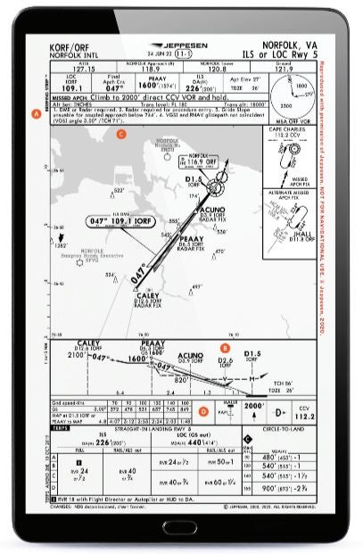
A trip into Norfolk, Virginia (KORF), might just find you flying the ILS or LOC Runway 5 on a drippy, low visibility, overcast day like I needed to do a couple of years ago when dropping off friends for a series of meetings. Norfolk’s primary airport sits nestled in some pretty active airspace with a variety of airports nearby, so expect a busy approach radio environment.

A. RADAR REQUIRED

Many approaches have a method to establish onto the approach without the use of ATC vectoring assistance. This approach does not. Note 2 specifically indicates: “Radar required for procedure entry” in order to get the pilot established onto the approach. While many GPSs are likely to be able to navigate directly to the CALEY waypoint, it is worth noting that this is an “IF” (intermediate fix), not technically an “IAF” (initial approach fix). So, even if your GPS can get you there, ATC needs to be providing radar services as you are vectored onto the approach or navigate directly to CALEY in order to set you up on the approach somewhere outside of the PEAAY waypoint.

B. DME FROM THE LOC

The DME on this approach is sourced from the ILS receiver, but it doesn’t count down to “zero” like many do. In this case, it is because there is also an ILS approach to the opposite runway, 23, and that is where the DME transmitter is located. If you were flying the ILS to Runway 23, it would count down to a DME point closer to zero, but since this approach is using the DME source from the opposite end of the runway, your missed approach point when flying the approach as a localizer would be at 1.5 nm. This is also helpful to refer to as you fly the ILS and descend to the decision altitude. It’s also worth noting that it could be easy to have aDME source selected to the ORF VOR, which is located on the field, but that would also generate an incorrect DME datapoint to use when flying this approach.

C. GS AND AP LIMITATIONS

A small note in this approach indicates: “Glide slope unusable for coupled approach below 744 [feet].” For many pilots who actively utilize automation, this is an easily missed note. This is an indication that by the time they reach this altitude, they need to transition to hand flying the aircraft. Technically, allowing the autopilot to remain coupled to the glide slope beyond this altitude is not authorized. For an approach with a decision height down to 226 feet and a TDZE of 26 feet, it means a pilot is going to need to keep those hand-flying skills ready to take over for a portion of the descent after passing the FAF at PEAAY and before reaching the DA.

D. CORRECT VOR FOR THE MISSED

A pilot who chooses to go missed on this and proceed with the published missed approach can easily mix up exactly what they need to do. Seeing the ORF VOR denoted on the approach plan view, and a radial denoted to the JHALL intersection just to the right of it on the chart, a pilot might initially assume this is what they will do. But a note on the box indicates this is an “Alternate Missed APCH Fix.” This would be applicable only if the pilot was doing something other than the expected published missed approach procedure, had been assigned the alternate missed approach, or requested it. A pilot would be expected to fly directly to the CCV VOR and hold on the 029-degree inbound course. This requires a pilot to use a frequency and navigation source they had not used until this point on the approach. A savvy pilot might have this frequency in the standby well ahead of time if they thought there was any chance they might go missed.

Login

New to Flying?

Register

Already have an account?