fbpx

Hawaii’s Volcano Eruption ‘An Exciting Thing’ for Pilots

Volcanic ash clouds can foul aircraft engines, ruin aircraft exteriors, and release hot, poisonous gasses that can be deadly for pilots.

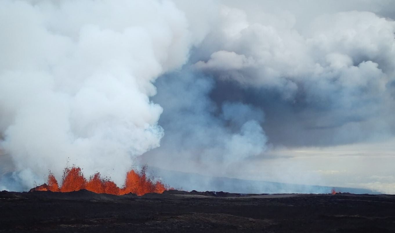
Volcanoes and Hawaii go hand in hand, as the island chain was formed by volcanic activity. The pilots who fly there gain a healthy respect for volcanoes, such as Mauna Loa, which is located on the south central part of the big island and is currently erupting.

The eruption began around 11:30 p.m. on Sunday, November 27, when one of the fissures on the slope of Mauna Loa began throwing lava 200 feet into the air, according to HawaiiNewsNow.

Emergency management officials had been anticipating the eruption as there have been several earthquakes in the vicinity of the volcano caused by the movement of magma beneath the earth’s surface. According to volcanologists, this is often a sign that an eruption is forthcoming.

There are no reports of airport closures as a result of this eruption, although as a precaution Southwest Airlines canceled most flights into and out of Hilo International (PHTO) on Monday. Those flights were expected to resume Tuesday after airline officials determined there was no ash in the air.

An ashfall advisory was initially issued for the island, however that has since been canceled.

The winds on the Big Island known as the trade winds usually blow from the northeast, and this trend would take ash away from populated areas. Very rarely, winds come from the south; these are called the Kona winds, and they could potentially bring ash from the volcano over populated areas, such as the community of Hilo.

According to the United States Geological Survey (USGS), there are no current threats to people or property from the lava flow. Those in the vicinity are encouraged to check the USGS information site frequently and the situation may change.

Exciting for Pilots

Cessna 210 pilot and FLYING Magazine contributor Jim Barrett, who lives 200 miles from the volcano, on Oahu, says it’s interesting to have a volcano TFR (temporary flight restriction) pop up on ForeFlight, as until now the only experience he had with volcanic activity as a pilot was the theoretical knowledge he picked up some 30 years ago in private pilot ground school.

“The TFR is 5 nm radius from surface up to 19,000 feet,” Barrett told FLYING, adding there are two TFRs; one is circular, and the other is triangular-shaped and covers the lava flow coming from the volcano’s fissures. “The TFRs are in place until December 5,” Barrett said, noting that there are pilots who will fly just outside the TFR to get a view of the volcano and the lava flow. 

“It is an exciting thing for pilots to see from outside the TFR.” he said.

A TFR with a 5 nm radius was issued for Mauna Loa.

Even when the Mauna Loa is not erupting, pilots need to monitor their altitude in the area, Barrett said.

“There is a limitation on low you can go; it is marked on the VFR sectional like a wilderness area. You cannot go any lower than 2,000 feet agl.”

Barrett added there are notes on the VFR sectional warning pilots about magnetic disturbances in the vicinity of up to 10 degrees.

The  FAA and Volcanoes

In private pilot ground school, pilots are told to not fly through a volcanic ash cloud.

Section 13 of FAA Advisory Circular 00-45E, Aviation Services Section 13—Volcanic Ash, warns pilots that the ash, which is composed of rock, silica and hot, poisonous gasses, can be deadly and propeled with such force there is no chance the aircraft can outclimb the cloud—very similar to thunderstorms but much more deadly.

Asphyxiation is what kills in a volcanic eruption, as noted autopsies on people who died in the eruption of Mount St. Helens. The eruption killed 57 people. According to USGS, they died from inhaling hot gasses.

The ash created by St. Helens filled the atmosphere with fine particulates that dropped visibility dramatically, shutting down both ground and air travel. More than 1,000 flights were canceled as several airports were shut down for weeks due to ash accumulation and poor visibility. Aircraft that were outside and covered with the ash had fouled engines and their exteriors were destroyed—some looked as though they had been sandblasted.

PIREPs for Volcanic Eruption

Section 13 of Advisory Circular 00-45E notes the Volcanic Ash Advisory Center (VAAC) has two products it issues when there is a volcanic eruption: the Volcanic Ash Advisory Statement (VAAS) and forecast charts of ash dispersion. These are based on PIREPS, MWO SIGMETS, satellite observation, and volcanic observatory reports.

When giving a PIREP about a volcanic eruption, pilots are asked to indicate the location, time, and date of the eruption, if they see an ash cloud and or detect sulfur dioxide in the cabin. The height of the initial ash cloud is also appreciated.

Login

New to Flying?

Register

Already have an account?