











Youve been in the clag for what seems like hours. The monochromatic gray outside the windows is broken only by the raindrops streaking up your windscreen and meandering back at a slower pace along your side windows. Youve turned off your strobes, but you can see the reassuring red and green glow of the recognition lights at your wing tips, reflected back from the thick grayness. Before takeoff, Flight Service told you a large low-pressure trough is blanketing the 288
Engine-Out IFR Approach
Youve been in the clag for what seems like hours. The monochromatic gray outside the windows is broken only by the raindrops streaking up your windscreen and meandering back at a slower pace along your side windows. Youve turned off your strobes, but you can see the reassuring red and green glow of the recognition lights at your wing tips, reflected back from the thick grayness.

Key Takeaways:
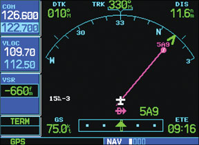
- In an engine-out emergency within Instrument Meteorological Conditions (IMC) where no instrument-equipped airports are within gliding distance, a GPS moving map navigator can be used to fashion a "poor man's" instrument approach.
- To create a makeshift localizer, select "Direct-To" for the chosen runway, then manually fly to intercept its extended centerline by periodically updating the GPS course until it aligns.
- A "poor man's glideslope" can be established using the GPS's Vertical Navigation (VNAV) page by setting a target altitude of zero feet at zero distance from the runway's midpoint.
- This procedure is for dire emergencies only, not FAA-sanctioned, and requires intimate knowledge of your GPS and surrounding terrain, as it offers no guaranteed obstacle clearance.
Key takeaways sponsored by Aviator Pro | Start Your Training ->
See a mistake? Contact us.

