Last month’s Clinic took us to western Kentucky where we wrangled a circling-only VOR-A approach. In September, we untangled an ILS/GPS hybrid in upstate New York. For another take on a ground-based approach using GPS, plus a circle-to-land, we head to Alpena, Michigan on the shore of Lake Huron. The lake’s a frequent source of low-level clouds that often arrive at inconvenient times to obscure useful things like runway thresholds.
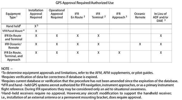
We’re (barely) equipped for RNAV, with a basic GPS approved for en-route and terminal navigation. To sweeten the deal, the on-field VOR (APN) is out of service and Runway 7/25 is closed. With a 15-knot breeze from the south, Runway 19 is best, but the VOR and RNAV approaches are NA. Not a big deal; the 1500-foot ceiling works to descend via the ILS 01, break out and coordinate with the tower to fly a downwind for 19. This seems like a good plan, except…
Finding Fixes
We’ll arrive on Victor 45 to the Alpena VOR, keeping in mind that halfway to Alpena we can’t switch over as we would normally. Instead, we’ll turn to the GPS flight plan, which includes WHOOP to TUSYU to AILES. AILES is our IAF leading to the ILS course inbound.
Keeping with the (barely) equipped nature of our GPS, the database is six months old. Current data is the best and safest way to operate, but the AIM provides a workaround. Table 1-1-6 (shown below) says our IFR (no approach) GPS must have “verification of data for correctness if database expired.” Since our tablet data is always current, we can easily compare—after confirming that our GPS flight-manual supplement doesn’t supersede and require current data.
Second missing piece: The fine print says “ADF required.” FELPS is the FAF for the localizer version, which we won’t need. But it’s also the missed approach holding fix, which we do need. Per that AIM guidance, it’s generally acceptable to use GPS for navigating to or holding over a VOR, NDB or compass locator. Since FELPS is 7.3 DME from the Alpena VORTAC, we can triple-confirm.
Missing MDA
Passing WHOOP at 5000 feet we coordinate with ATC for vectors. We spot an encouraging break in the clouds. But checking KAPN weather, it’s lower near the lake: 900 scattered, 1600 broken, with vis down to two miles—too low for a visual. How about a circle? Sure, the ceiling’s plenty high. Unable, for yet another missing piece: no circling MDA. Must be the nearby obstacles. With a 9000-foot runway, we’d consider landing downwind, but there’s too much tailwind today.
We’re comfortable flying a pattern as low as 700 feet AGL. (We practice that, a lot, at home.) Just make it a left downwind due to obstacles just west of the localizer course. To circle from an approach without circling minimums, the options are: 1) wait for better weather and cancel, 2) use Special VFR, or 3) get a contact approach. Whatever the choice, coordinate well in advance. If the tower’s closed, which it might be, coordinate intentions with Minneapolis Center. (Alpena Approach and Tower operate from 8 a.m. to 4 p.m. local time as services come from the Guard base there.)
The first option would be ideal—if the weather’s better than 1200-3. This isn’t a visual approach from the IFR rulebook; it’s VFR in Class D airspace (or Class E if Tower’s closed), which requires flying 500 feet below the clouds with visibility at least 3 miles.
The other alternatives eliminate the cloud separation and visibility margins, so check Option 2: Switch from an IFR descent to Special VFR and all we need is a mile and clear of clouds. Terrain/obstacle clearance is up to us, but we can choose our own course to Runway 19, using the localizer for situational awareness. We’ll get to stay in the system longer, so SVFR isn’t of much benefit. While useful to sneak past local fog, it’s easy to break VFR regs (unless in Class G, typically from the surface to 700 or 1200 feet AGL, you can’t already be in one-SM visibility before getting SVFR).
Contact It Is

A contact approach affords us the protection of the IFR system without flying a full IAP. We can top it off by circling at our discretion, maintaining one mile visibility and clear of clouds. Again, coordinate ahead of time as the pilot must initiate the request and communicate intentions for what amounts to a DIY approach. Do this before AILES so ATC is prepared.
We’ll get cleared for a descent to AILES, start the contact approach there, and continue descent to perhaps 2000-feet MSL, to get below the overcast at 1600-feet AGL and remain above the scattered clouds at 900 feet AGL. Fly the localizer for course guidance and obstruction protection, then sidestep to the left downwind for Runway 19. Get below the scattered layer when possible with a descent to our DIY 700-foot pattern altitude. We’re still responsible for terrain and obstacle clearance, but we do get separation services from IFR and SVFR traffic. Another advantage over SVFR is that we don’t need the airport in sight to get cleared. We only need an expectation that we will see it in time to land.
We’ll be sure to discuss missed approach instructions beforehand. Tell ATC we’ll fly the published missed if still on the localizer. Northbound on the left downwind, it’s logical to follow the published missed: A climbing left turn to 2800 feet, and head to FELPS. If on final for 19, we must make sure it’s safe and OK with ATC to miss by flying runway heading—better yet, the LOC BC—straight for the fix. Otherwise, get instructions. And, if conditions allow, it’s fine to continue to fly the left pattern or simply circle over the airport.
Just so we’re also in tune with the regs, see what the Instrument Procedures Handbook has to say on these considerations: any (emphasis added) “published missed approach procedure provides obstacle clearance only when the missed approach is conducted on the missed approach segment from or above the missed approach point, and assumes a climb rate of 200 feet/NM or higher, as published. If the aircraft initiates a missed approach at a point other than the missed approach point, from below MDA or DA (H), or on a circling approach, obstacle clearance is not provided by following the published missed approach procedure, nor is separation assured from other air traffic in the vicinity.”
On the contact approach, we can maneuver wherever we deem safe: “Unless otherwise restricted, the pilot may find it necessary to descend, climb, or fly a circuitous route to the airport to maintain cloud clearance or terrain/obstruction clearance.” That’s a lot of flexibility around and over the airport as well. Just watch for obstacles, watch and listen for VFR traffic, and use “normal maneuvers” as prescribed in §91.175.
All things considered, getting into an airport without the typical published procedure opens up a lot of discretion on the PIC’s part. We get to decide the route of flight, the minimum weather to make it work, and even the set of rules we want to use. As long as we meet the regs and play it safe, we can find good solutions to even challenging puzzles.
Elaine Kauh is a CFII in eastern Wisconsin. She enjoys working out puzzles that explore the fine balance between legal and safe in near-impossible situations like this, but her actual flying is far more conservative. She urges extreme caution to any pilot pushing the edges of the envelope like this.
