Youve been in the clag for what seems like hours. The monochromatic gray outside the windows is broken only by the raindrops streaking up your windscreen and meandering back at a slower pace along your side windows. Youve turned off your strobes, but you can see the reassuring red and green glow of the recognition lights at your wing tips, reflected back from the thick grayness. Before takeoff, Flight Service told you a large low-pressure trough is blanketing the 288
Engine-Out IFR Approach
Youve been in the clag for what seems like hours. The monochromatic gray outside the windows is broken only by the raindrops streaking up your windscreen and meandering back at a slower pace along your side windows. Youve turned off your strobes, but you can see the reassuring red and green glow of the recognition lights at your wing tips, reflected back from the thick grayness.
Key Takeaways:
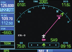
- In an engine-out emergency in Instrument Meteorological Conditions (IMC) with no available instrument approaches, a GPS moving map navigator can be used to fashion an improvised approach to an unequipped airport.
- This technique involves using the GPS "Direct-To" function to establish lateral guidance by aligning with the extended runway centerline and configuring the VNAV page to create a constant descent path for vertical guidance.
- This is a strictly emergency-only procedure, as the improvised "glideslope" does not guarantee obstacle clearance, emphasizing the critical need for intimate avionics knowledge, terrain awareness, and practice to maximize survival chances.
Key takeaways sponsored by Aviator Pro | Start Your Training ->
See a mistake? Contact us.
