The word “airspace” is a relative newcomer to our lexicon, and when first coined in the early years of the previous century probably seemed suspiciously redundant, not to mention anathema to the individualists of the era. Times have certainly changed since then, and our national airspace system has gotten more complicated. Given the “mission creep” so characteristic of todays bureaucracies, we can presume the rules under which we fly will not revert back to being less restrictive. With all the exposure given to airspace security and inadvertent entries into temporarily restricted airspace, this is a good time to review the various types of Special Use Airspace, otherwise known by the autocratic acronym SUA, with an emphasis on the different ways they are charted. Whats So Special About It? What is SUA? Its any airspace of defined dimensions, having a base and (in most instances) an upper altitude wherein activities must be confined because of their characteristics or wherein limitations may be imposed upon aircraft operations that are not a part of those activities. (There is always going to be a base, by the way, but not always a ceiling: For example, the area to the east of the Kennedy Space Center has no upper limit.) There are about a half-dozen types of “formally defined” SUA, which are summarized in the sidebar on the opposite page. From a bureaucrats viewpoint, there are basically two types of SUA: regulatory (in the sense they are defined by formal rulemaking) and non-regulatory. Prohibited Areas and Restricted Areas (as well as Class A, B, C, D and E airspace) are regulatory. These two regulatory SUAs are implemented by FAR Part 73, but MOAs, Warning Areas, Alert Areas and controlled firing areas (CFAs) are non-regulatory. Special use airspace (except CFAs) are charted on Sectional and en route charts and descriptions include hours of operation, altitudes, and the controlling agency. In addition, Military Training Routes (MTRs) certainly qualify as special use, although they arent officially considered SUA. (Anything moving at 400 knots within 1500 feet agl qualifies as “special” in our book.) There are also two other types. If you fly within an Air Defense Identification Zone, or ADIZ, which is usually along coastal waters, you get to file a flight plan that isnt VFR or IFR, but Defense VFR, or DVFR. We lucky souls in the Washington, D.C., area get to file an ADIZ flight plan. For the offshore version, you need to file periodic position reports and identify yourself before returning to or entering domestic airspace. Otherwise, you might have a new wingman sporting all kinds of neat pyrotechnics. In Alaska, these areas are known as Distant Early Warning Identification Zones, or by the acronym DEWIZ. 388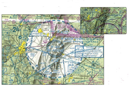
Airspace Charting Traps
Special Use Airspace charting can be confusing and increase the risk of blundering into areas youre not supposed to. Heres how to tell the difference.

Key Takeaways:
- Special Use Airspace (SUA) defines areas with operational limitations, formally categorized as regulatory (e.g., Prohibited Areas, Restricted Areas) and non-regulatory (e.g., Military Operations Areas, Warning Areas, Alert Areas).
- Regulatory SUAs like Prohibited and Restricted Areas carry significant risk if entered without authorization, often having specific operating hours for Restricted Areas.
- Non-regulatory SUAs such as Military Operations Areas (MOAs) and Military Training Routes (MTRs) involve high-speed military activities, necessitating extreme caution and prior advisories for non-participating pilots.
- Pilots are responsible for maintaining thorough situational awareness of all SUA types, adhering to charted information, and complying with ATC instructions to ensure safety and prevent inadvertent entries.
Key takeaways sponsored by Aviator Pro | Start Your Training ->
See a mistake? Contact us.
