
One of the most impactful elements of the NAS (national airspace system), arguably one of the most dangerous, is thunderstorms. They terrorize our skies and our airports every summer. They’re an unavoidable fact of life in aviation. So let’s look at how pilots and ATC work together to deal with them.
‘Tis the season my aviation enthusiasts. Thunderstorms are in full swing. The time has come for the madness of deviations, re-routes, and closing airports. There isn’t a more chaotic time in aviation, particularly going into complex and congested airports. Has Denver International ever had less than 100 microbursts in a single day between June and August? Unlikely.
I can say with some certainty though that if summer flying isn’t your thing, ATC dislikes it more. It’s brutal. All our tools that help predict aircraft conflicts become practically useless when aircraft deviate off course. These tools use your filed route of flight, speed, altitude, etc. to project where you will be in the future and compare it to other aircraft in the system. This information is static, and reliable … when you’re on course. But the computer gives up if you’re off course.
So ATC is left using good old-fashioned scanning skills and proactive clearances. Relax, it’s not that bad … We train for this. Controllers are highly skilled and have gone through years of training to ensure your safety. We even practice on specialized simulators. We have constant refresher training. So, yes, we have resources and training.
But I digress. Let’s continue with how ATC handles the summertime madness. There are factors to consider for safety around thunderstorms. We’ll look into them.
The Basics
For those who don’t know the term “convective activity” (shame on you), this is weather that produces many dangerous elements—lightning, heavy rain, icing, hail, and severe turbulence—commonly associated with thunderstorms.
Information about convective activity is disseminated to pilots and controllers through “convective SIGMETs” which are required to be issued by ATC when they become available. Convective SIGMETs are valid for two hours from the time they are disseminated, or until they are superseded by another hourly issuance.
So, let’s discuss some of the elements involved in avoiding severe weather: Traffic Management Units, Center Weather Service Units, ATC Weather Radar, and Deviation Clearances.
Traffic Management Units
On average, there are 45,000 IFR operations daily. Large embedded thunderstorms, like those that build in the central United States and around Florida, significantly disrupt the flow of this traffic. Not surprisingly, this disruption needs to be managed to create a safe and orderly flow of traffic. That’s where Traffic Management Units (TMU) come in.
TMU is an operational branch of the NAS that is responsible for implementing strategic plans to manage the flow of traffic. They assess the volume and complexity of traffic that is projected to traverse the NAS. Even when convective activity is not present or forecast, there are many unique routes assigned to manage the flow of traffic into and out of busy airports.
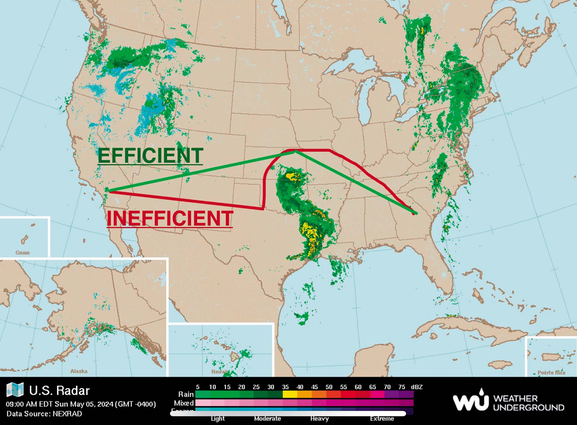
When convective activity gets in the way (real or forecast), TMU implements strategic traffic management initiatives (TMIs) that assign proactive routes to increase traffic efficiency. Take a look at the image below.
The red flight is an aircraft that filed on a relatively direct route, but then encounters the thunderstorms and must deviate around. It’s inefficient and introduces more complexity for air traffic control. For the green flight, TMU has proactively implemented specific routing around the thunderstorm. This route is much more predictable and efficient.
TMU will also issue routing while aircraft are en route. Thunderstorms are dynamic and can build quickly, making it necessary to initiate tactical reroutes in the air.

This CWA is a product of the CWSU.
Center Weather Service Units
So where do controllers get their weather information? How do we know what is happening and what will happen in our airspace?
All air route traffic control centers (ARTCCs, “Centers”) have a Center Weather Services Unit (CSWU). They are a crucial part of informing controllers and traffic management units about existing and impending weather. CSWUs have a dedicated meteorologist with a wide array of technology and weather displays to analyze and predict weather. They can provide real-time information that helps with tactical decisions inside ARTCC airspace.
Their entire focus is on aviation weather for the center. They produce specialized forecasts and advisories for thunderstorms, turbulence, icing, and precipitation, all of which are critical to the National Airspace System.
Every day, CWSUs conduct three Pre-Duty Weather Briefings, offering vital situational awareness of aviation weather issues to air traffic controllers. These face-to-face, on-the-spot briefings are crucial to ensure that FAA personnel can route air traffic safely and efficiently. Additionally, CWSU meteorologists issue Center Weather Advisories (CWAs) and Meteorological Impact Statements (MISs) as needed.
CWAs are aviation weather warnings for conditions that meet or approach national in-flight advisory criteria, such as AIRMETs or SIGMETs. They are issued for aviation hazards expected to occur within two hours and can include thunderstorms, turbulence, icing, heavy precipitation, low IFR, surface wind gusts over 30 knots, low-level wind shear, volcanic ash, and even dust or sandstorms. These advisories are essential for addressing unforeseen hazards or supplementing forecasts from the Aviation Weather Center (AWC) or the Alaska Aviation Weather Unit (AAWU).
On the other hand, Meteorological Impact Statements are unscheduled forecasts tailored to meet the unique requirements of the host ARTCC. They provide additional information on current or expected weather conditions, aiding air traffic controllers in-flight operations planning.
The meteorologists at CWSUs are highly knowledgeable about the diverse weather regimes within their large forecast areas, which can include mountainous regions, deserts, and tropical areas. Their expertise ensures that pilots receive the most accurate and relevant weather information for their routes.
The importance of CWSUs was underscored by the tragic 1977 crash of Southern Airways Flight 242, which encountered a severe thunderstorm en route to Atlanta. The investigation highlighted the need for timely weather information for air traffic controllers, leading to the establishment of the CWSU program.
CWSUs are unsung heroes of aviation. They make sure to provide the critical weather data that helps keep our skies safe.
ATC Radar
Imagine you’re a pilot cruising at 35,000 feet, and you hear from ATC that there’s a storm ahead. How does ATC know this? The answer lies in the sophisticated technology of weather radar. I can’t stress enough the vital role that weather radar plays in air traffic control.

Weather radar is a crucial tool that gives air traffic controllers a real-time visual representation of convective activity, such as thunderstorms. This technology works by emitting radio waves that bounce off precipitation particles like raindrops, hail, or snow. When these radio waves return to the radar antenna, they provide data on the intensity and location of the precipitation.
For example, let’s say a line of thunderstorms is brewing over the Midwest. The weather radar detects this activity and displays it on the radar screens in the control centers. The radar images are color-coded, with blue for moderate precipitation, hatched green for heavy precipitation, and solid green for extreme precipitation.
This visual information is invaluable for air traffic controllers. It allows us to see exactly where convective activity is occurring and how it’s moving. With this data, controllers will advise pilots on the best option for altering their flight paths to avoid the dangerous weather. In fact, ATC must issue the weather depicted on their radar scopes, if it is moderate or greater. Here is the phraseology we are required to use:
AREA OF (Intensity) PRECIPITATION BETWEEN (number) O’CLOCK AND (number) O’CLOCK, (number) MILES, MOVING (direction) AT (number) KNOTS, TOPS (altitude). AREA IS (number) MILES IN DIAMETER.
It is often difficult to know exactly which direction the weather is moving or how fast, so it is possible (even likely) that you won’t hear ATC issue that specific information.
There are limitations to ATC radar. Often times, the anvil of a thunderstorm will not be depicted on their weather radar. Because of this, they may suggest that you deviate in the direction the anvil stretches. It’s important for you to be aware of this and make the appropriate decision for your flight.
Weather radar is a cornerstone of air traffic control, providing a clear visual location of convective activity. It enables controllers to make informed decisions, guiding pilots safely around hazardous weather and maintaining the smooth flow of air traffic. This technology is a perfect example of how advanced tools are used to keep our skies safe and our flights on schedule.
Clearances
The final—perhaps most important—topic on thunderstorms to discuss is weather-deviation clearances. It’s extremely important to understand what is allowed and expected in these clearances.
Air traffic controllers will issue deviation clearances when requested by the pilot, or sometimes proactively when they know a deviation will be necessary. The deviation clearance can be left of course, right of course, or both left and right of course. Deviations are always lateral and never vertical. If you ever require a change in altitude to avoid whether, the altitude change must be explicitly requested and granted.
Air traffic controllers can (and do) anticipate separation based on your IFR flight plan. The route in your flight plans is static and predictable. There are multiple technologies and systems in place that display and track your flight path based on your filed route of flight (including speed and altitude). These systems will alert air traffic controllers of potential conflicts and allow controllers to trial alternative routes and altitudes based on this static information. So what happens when you deviate off this predicted route? Yes, everything that could be anticipated based on that information is no longer as useful as it was. That doesn’t mean it is completely useless, but it’s pretty close.
When you deviate off course far enough, you go into what is known as “free track.” This term describes when your radar track is no longer in conformance with the track expected by the computer system. Meaning, your actual flight path isn’t following your filed route path. When this occurs, the radar target that is associated with your flight will change. This is the indication that tells controllers they can no longer use the computer system’s conflict predictions as reliable information for separating you from other aircraft.
Pilots should request deviations as early as possible with as much specific information about the deviation as possible. If you need to deviate for approximately 100 miles, include that in your request. If you need to deviate 30 degrees off course, include that as well. Any information that helps the controller formulate a mental picture of where you will be going is extremely valuable information.
Specifying this information in your request won’t restrict you to it. It’s just a clear and important communication of your needs. The only thing that restricts you is the actual clearance the controller gives you. If you say that you need 30 degrees to the right, the controller will give you that much or more (if they can). Traffic and restricted Airspace are the only likely reasons he/she might not give you everything you request.
Let’s look at a few deviation clearances and discuss what they allow you to do and what the controller expects from you.
“DEVIATION LEFT OF COURSE APPROVED.”
This is a very basic clearance. You may deviate as far left as necessary with no restriction on how far left you go. You are permitted to turn back to the right (once you are left of your original course), if necessary, so long as you do not cross your original flight path. If you cross to the right side of your original flight path, you are now deviating right of course, which you weren’t cleared to do.
“DEVIATION LEFT AND RIGHT OF COURSE APPROVED.”
This clearance gives you the most flexibility. You can go left or right of your original course as needed, with no lateral restriction.
“DEVIATION UP TO 30 DEGREES LEFT/RIGHT/LEFT & RIGHT OF COURSE APPROVED.”
This clearance is the same as the two clearances above, with a restriction to only deviate within a wedge of airspace 30 degrees left and/or 30 degrees right of your original course. Imagine a fan spreading out in front of you with a 30-degree angle. You can deviate within that fan “wedge” of airspace.
So now that you have the clearance to deviate, how do you get back on course when you’re done deviating? The answer to that question depends on the nature of your clearance.
If you received a clearance like any of those above, then you are not cleared back on course when you’re through with your deviation. Air Traffic control will expect you to report being finished with your deviation and ready for clearance on course. ATC will then clear you direct to a fix down the line.
In most deviation clearances, ATC will include a clearance on course with your deviation clearance:
“DEVIATION LEFT OF COURSE APPROVED, WHEN ABLE CLEARED DIRECT (fix) AND ADVISE.”
With this clearance you are permitted to proceed directly to the specified fix when you are finished with your deviation. It is always preferable that you report being direct your next fix, even if you are not specifically instructed to do so. This tells the controller you are finished with your deviation clearance and the controller will update your route accordingly.
Closing Thoughts
Thunderstorms are serious business in aviation. They require a great deal of communication, coordination, and action to circumvent safely. While working with air traffic control to navigate the complexity of thunderstorms, it is paramount that you communicate your needs clearly and as early as possible. Working together is the best way to ensure the safety of your flight around convective activity. After all, that’s what everyone wants.
Mac Lawler is creeping up on 15 years of experience as an air traffic safety professional. When he’s not telling pilots what to do, he spends his time with family and friends. He’s a certified scuba diver and avid fisherman. On multiple occasions he almost caught the biggest fish you ever saw.
