fbpx

RNAV (GPS) RWY 25L: Deer Valley, Arizona

Flying into the swarm of training, pilots can use this approach for alignment.

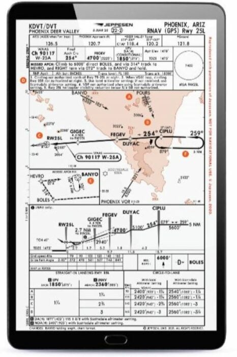
A busy training and GA-use airport in the northern part of Phoenix, Deer Valley Airport (KDVT) has a limited number of GPS-only approaches from which a pilot might choose. While the weather is rarely IFR in the area, a pilot might choose to use the RNAV Runway 25L procedure to help align with an intended landing runway in the suburban landscape, to avoid confusion with the multiple airports in the area, or just as a part of their training or currency practice.

Featured

A. Multiple Places to Start

A pilot approaching from different directions might choose different waypoints across which they could make a transition to the one official IAF listed at CIPLU. An approach from the north might have a pilot choose (or ATC assign) crossing the POURS waypoint. A pilot approaching from the south might utilize the Phoenix (PHX) VOR. In these cases, they would need to complete a course reversal to establish onto the approach either using a lapin the hold or a procedure turn on the protected side of the hold before proceeding inbound on the approach course.

B. Hold and Inbound Courses

A slight but important difference, the inbound course on the hold at CIPLU is 259 degrees, while the inbound course from this point along the final approach path is 254 degrees. The good news is that the GPS should sequence this, and if you are utilizing an autopilot, it should follow the course change. If you are hand-flyingthe approach, be aware that a slight change will be needed to avoid a course-needle deflection.

C. Parallel Runways

While one runway may be nearly double the size of the other, if you are flying this approach, be sure you know the one for which you have been cleared to land. Closely situated parallel runway scan keep traffic close by and add to confusion at times.

D. Circling South, but Not at Night

If you happen to be circling to Runway 7R, be sure to take note that the indication on the chart is that a circle is “not authorized north of Runway 7R-25L. ”This means a circle to the south for right traffic: This is non-standard. Also worth noting is that circling, even though it may seem like a simple side step, is not authorized at night to 25R. Expect to land on the big runway from this approach at night.

E. Multi-Step Missed Approach

The missed approach isn’t just a straight-to-a-point-and-hold event. If a pilot has a need to go missed upon reaching the decision height on the LPV, or at the MAP if flying the LNAV on this approach, it will first take them to the BOLES waypoint while climbing to 6,000 feet msl. From there, they will turn and head to the HEVRO waypoint, and then turn again to the BANYO waypoint. Here is where they would hold and wait for either further instructions from ATC, or potentially head back to the IAF at CIPLU if they were going to try the approach again.

F. DME Distance Holds

Holds aren’t just established by time now. Although one-minute holds still exist, there are other means of determining leg length. On this approach plate, both the depicted holds are based on nautical mile distances, not timing. The hold depicted at CIPLU has a pilot fly 5-nm legs on the inbound course, and the hold at BANYO for the missed approach has a pilot fly 6-nm legs on the inbound leg. GPS certainly helps make this easier—and it’s the only way to do them on a GPS-based approach—but they are different from what many pilots might have become accustomed to from their initial training.

This article was originally published in the March 2023 Issue 935 of  FLYING.

Login

New to Flying?

Register

Already have an account?