Register

More Weather Radar

In our last issue, we talked about the building blocks of weather radar-how it was developed, the basics of radio waves, problems with radar sampling, and the important differences between composite and base reflectivity. If you havent read that, I highly recommend you do so to get a good grounding in radar fundamentals. In this issue well take that knowledge and teach you a bit about interpretation.

Gemini Sparkle

Key Takeaways:

  • Prioritize understanding the atmospheric environment (instability, shear) through resources like SPC outlooks, as this dictates a storm's potential severity more than radar alone.
  • Radar primarily detects large water droplets, ice crystals, and hail (not water vapor or small cloud droplets). High reflectivity (>60 dBZ, red/magenta) at any altitude, especially at high levels or forming "overhangs" with "weak echo regions," indicates dangerous storms with strong updrafts.
  • Look for specific patterns indicating severity: strong reflectivity gradients, concavities (like "hooks" or V-shapes), and isolated cells. Be aware of attenuation in airborne radar and the inherent data delays in cockpit displays, using them for planning rather than real-time navigation through storms.
  • Recognize hazards associated with storm organization, such as Mesoscale Convective Systems (squall lines) and bow echoes, noting that "Tail-End Charlie" cells or isolated storms often pose the highest risk due to less competition for moisture.
See a mistake? Contact us.

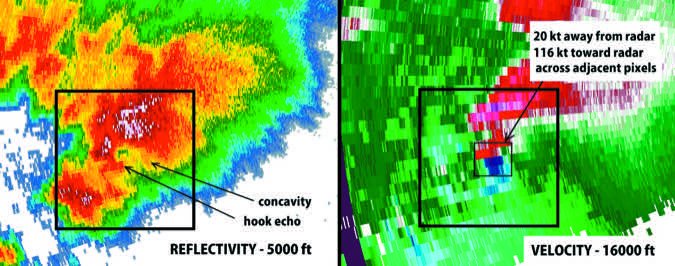
In our last issue, we talked about the building blocks of weather radar—how it was developed, the basics of radio waves, problems with radar sampling, and the important differences between composite and base reflectivity. If you haven’t read that, I highly recommend you do so to get a good grounding in radar fundamentals. In this issue we’ll take that knowledge and teach you a bit about interpretation.

My background is primarily in meteorology and I hold a certification on the NEXRAD radar, so with this grounding in weather radar I can teach you some tricks and techniques to help you make sense of what you’re seeing. I hope this article helps you think like a forecaster so you can adapt to the data available in the cockpit and make decisions that will assure a safe flight. You can also use the information just sitting at home as a storm rolls into your city.

Ready to Sell Your Aircraft?

List your airplane on AircraftForSale.com and reach qualified buyers.

List Your Aircraft
AircraftForSale Logo | FLYING Logo
Pilot in aircraft
Sign-up for newsletters & special offers!

Get the latest stories & special offers delivered directly to your inbox.

SUBSCRIBE