Regard the Jeppesen version of the RNAV (GPS) Rwy 19 approach to Meridian, MS (KMEI). This chart shows the simplest TAA you can have. The limit for a turn based on GPS is 90 degrees, so the maximum allowable turn from a route direct to the IAF to the leg after crossing the IAF is 90 degrees. This means each TAA should contain at least two sectors, divided by courses 90 degrees off the inbound course.
Terminal Arrival Areas (TAAs) were developed for GPS approaches to simplify navigation, segmenting the arrival area into sectors with defined altitudes and eliminating the need for specific feeder routes.
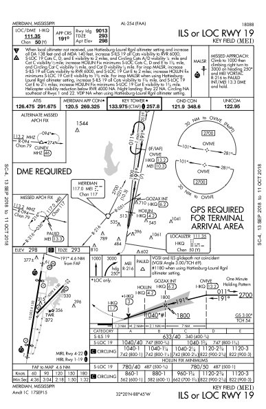
Early attempts to integrate TAAs into conventional (non-GPS) approach charts created "Frankencharts" with confusing or incorrect "GPS required" notes, causing ambiguity about actual equipment necessities for different approach segments.
TAAs replace Minimum Safe Altitudes (MSAs) on RNAV charts, and their use on non-GPS approaches highlights potential challenges for emergency safe altitude determination without GPS. Charting standards are evolving for clearer equipment requirements, a trend amplified by the future phasing out of VORs.
We pilots trust our cartographers. We must. We may wend our way from waypoint to waypoint, following the magenta pixels, but it’s black course lines and data on the chart that actually keep us out of trouble.
And then some well-meaning ground-dweller tries to simplify the presentation and bollixes up the whole thing.
CREATE A FREE ACCOUNT
Sign up to keep reading
Create a free account to continue. Already a member? Sign in below.