fbpx

ILS Z or LOC Z Rwy 19 Jackson, Wyoming

An approach to a mountain town replete with high-altitude hazards.

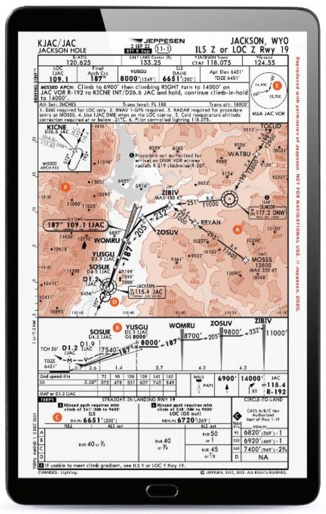
A destination in both the summer and winter, Jackson, Wyoming, is a city growing in its attraction and its aviation activity. With lots of high terrain around, an approach into this airport requires a pilot to closely follow altitude restrictions, especially if a missed approach becomes necessary.

Featured

A. Turns From IAFS to Intercept

With official initial approach fixes (IAFs) at the DNW VOR and the MOSSS points, a pilot might choose to transition from these along feeder routes to the ZIBIV intermediate fix (IF) onto the approach. From here, there will be more turns after reaching ZOSUV and WOMRU to establish onto the final approach path of 187 degrees for the ILS or LOC. Be ready to make turns whether flying the approach by hand or making sure your autopilot properly transitions along the procedure.

B. DME from the LOC

DME notations along the descent on this approach are listed as from the source IJAC; this is the localizer. With a VOR that is closely situated to the runway, selecting the wrong source would get a pilot close, but not give them the correct distance when identifying waypoints along the localizer path.

C. Climb Rate in FPNM, Not FPM

Going missed requires a pilot to fly a path, but in this case it has vertical climb requirements. There are two notes here that depend on if the pilot is flying the ILS or just the LOC approach. They require that a pilot can maintain at least a 241 or 248 feet per nautical mile climb gradient to designated altitudes (9,600 and 9,800 feet, respectively) if a missed approach is needed. This climb gradient is not a “feet per minute” climb that we see on the VSI, but “feet per nautical mile,” which requires you to get into the performance charts for the aircraft to determine if you can meet or exceed this requirement at the local density altitude.

D. VOR for the Missed

Going missed on this approach has a pilot transition their navigation source from the inbound using the LOC to using the VOR 192 degree radial to the KICNE waypoint. Be ready to switch that nav source and turn from the 187 degree inbound to a 192 outbound course from the VOR if needed.

E. Check Those MSAS

Many airports will have minimum safe altitudes around them a couple of thousand feet above the airport elevation. These altitudes will typically give 1,000 feet of obstacle clearance within a 25 nm radius of the point depicted. These are to be used in the event of an emergency where a pilot needs to get clear of terrain if off of a published segment of the approach. On this chart, altitudes of 14,900 feet to the northwest and 12,700 to the south and east would be needed to get to a clear altitude. For an aircraft not turbocharged or turbine powered, these might be unreachable altitudes.

F. Terrain All Around

An approach with a lowest decision altitude of 6,651 feet, there is no doubt that the pilot is going to find themselves well below terrain in the surrounding area. Numerous pinnacles above 10,000 feet msl—and a famous one to the northwest at 13,770 feet msl—might give a pilot pause when thinking about doing this approach in all but the best of conditions. The proximity of high terrain and its significantly higher levels than the approach in the valley makes it critical that a pilot not stray off course. A conservative one might choose to significantly increase their personal minimums at such an airport.

This article was originally published in the February 2023 Issue 934 of FLYING.

Login

New to Flying?

Register

Already have an account?