

By Ron Levy
Thunderstorms are one of the reminders that man is in many ways powerless before the forces of nature. They contain energies and forces that are virtually incomprehensible – often expressed in terms such as a comparison to an unimaginably large stack of thermonuclear weapons, any one of which whose destructive potential is itself almost unimaginable.
There are, from time to time, stories of aircraft entering thunderstorms. Sometimes they are quickly spit out, damaged and shaken, but able to limp to an airport and tell the tale. In other cases, they are either torn apart or simply squashed into the ground. Any way you look at it, no pilot in his right mind wants to get into a thunderstorm. (My apologies for the obvious aspersion on weather research/reconnaissance pilots).
Given that it is our intention to avoid penetrating a thunderstorm, or even coming close enough that its far-reaching effects can disturb our flight, thunderstorm avoidance requires both preflight planning and in-flight avoidance.
During preflight, you need to both locate the activity and determine where it is likely to go, and then select a route (both vertical and horizontal) to avoid that activity. The in-flight portion includes both identifying where you do not want to go, and, if youre IFR or in Class B airspace, effectively obtaining appropriate routing from ATC.
The process starts on the ground by looking for information on where convective activity is likely to be during the flight, as well as its nature and intensity. Part of the problem comes in identifying the conditions that feed the development of thunderstorms, namely warm unstable air, lifting action, and moisture.
Thunderstorms are generally associated with either frontal boundaries (squall line thunderstorms) or with masses of warm, humid air (what pilots still call air mass thunderstorms, but are now called ordinary thunderstorms by meteorologists). Thus, the search for likely thunderstorm locations begins with a check of the surface analysis and prognostic charts, which identify frontal locations and surface air flows.
The first cue is any cold front, especially one that is strong and fast-moving. Thunderstorms form in lines along the frontal boundary as a result of the warm air being lifted up by the cold air mass shoving underneath it. They may also form in lines in the warm air 50 to 150 nautical miles ahead of the front by the vertical motion of waves in the upper air being produced by the cold front much like the bow wave of a blunt-nosed boat. As those waves move up and down through the warm air, the upward portion can produce sufficient lifting action to stimulate thunderstorm development.
The second cue is a strong flow of warm, moist air over heated land. Typically, this involves southerly flows from the Gulf of Mexico up across the central or eastern United States when there is little high cloud to block the sun from heating the ground. As this warm, moist air moves across the hot landmass, it is lifted by convection.
In this situation, one of the key clues that air mass thunderstorms are likely is a dew point of 60-65F (around 20C) early in the day. This indicates there is enough moisture in the air that, when it is lifted above the freezing level, it will freeze into ice particles too heavy to remain suspended.
These will begin to fall, and this downdraft marks the transition to the mature stage of the thunderstorm. Dew points are readily available in the METARs.
Other cues to air mass storms are the K-Index, which identifies unusual lapse rates, and the Lifted Index, which is a measure of the amount of instability in the upper air. K-Indexes of 20C or more are considered to indicate a likelihood of thunderstorms, while negative values of the Lifted Index indicate instability, with values of -3 to -6 indicating conditions conducive to severe thunderstorms. K-Index and Lifted Index plots are available from a number of online weather sources.
There are also a number of textual sources of thunderstorm information, including Convective SIGMETs, Center Weather Advisories, and the Severe Weather Outlook that comes with the Area Forecast.
Of these, the Severe Weather Outlook is the most significant for flight planning purposes, in that it looks farther ahead than the others. These forecasts are prepared by the National Weather Services Storm Prediction Center. They provide both a verbal description of the areas in which thunderstorms are expected (which can be transcribed to a chart) as well as a synopsis of the conditions that could lead to thunderstorms and detailed descriptions of specific areas in which thunderstorms are expected to develop.
This product is included in all standard weather briefings from DUATS. The only caveat for the Severe Weather Outlook is that it is written in some instances in meteorologist-ese, and pilots with less background in the subject may need to just skip over such things as how many joules per kilogram of mean-layer convective area potential energy are expected.
The Planning Phase
To a great extent, the general planning strategies for air mass (area) versus frontal (line) thunderstorms are different. Generally speaking, light aircraft cannot expect to transit solid lines of thunderstorms without some very expensive equipment such as airborne radar and sferics devices such as a Stormscope or Strikefinder. However, there are a number of strategies for even non-equipped light aircraft to transit areas of isolated or scattered thunderstorms.
In planning flights where lines are expected, there are pretty much only two good strategies. If the aircraft does not have on-board weather gear, about all you can do is either plan to end-run the line or fly up to the edge of the line, land, and then sit and wait for it to move on.
When flying into an advancing line, this risks the chance of being hail-pounded as it passes over. When flying from behind a line, you may be forced to sit and wait a long time for it to either dissipate or pass far enough ahead to make another leap-frog jump up to its trailing edge, where you again land and wait.
When considering whether to attempt penetration of a line, one should keep in mind several things. First, the FAAs recommendation that you not fly within 20 nm of an active thunderstorm (especially on the downwind side), should not be dismissed lightly.
Hail, lightning and very strong winds (including updrafts and downdrafts) can extend that far out from the apparent edge of the storm. Thus, youd need a pretty big gap between cells in a line in order to punch through. Second, radar and sferics devices work on very different principles. One detects rain, the other lightning. Unless you have both, you are unlikely to be able to reliably pick your way between cells in a line.
The non-equipped aircraft has a much better chance of threading through areas of isolated to scattered storms than penetrating lines, as long as it stays in VMC. The key to doing this is getting up high enough to be above the base layer of clouds, where you can see the buildups and go around them.
The problem with this strategy is that you will probably have to get to 10,000 feet msl or more in order to do that, and that can be a struggle for non-turbocharged aircraft, as well as putting you in need of supplemental oxygen.
Despite the regs that say you are not required to have supplemental oxygen until you go above 12,500 feet for over 30 minutes, or above 14,000 feet for any period of time, the physiological fact is that if you fly above 10,000 feet msl for extended periods, your capabilities and performance will deteriorate.
This deterioration will be more marked for pilots who smoke, or are not in good cardiovascular condition, or for any one of several other medical reasons have reduced oxygen intake capability.
Paradoxically, it is often easier to fly in areas of area thunderstorms if youre VFR with flight following than if youre IFR. Since the clearances you want to achieve from thunderstorms are well in excess of the FAR 91.155 values for VFR, its not necessary to have an IFR clearance.
On the other hand, if you are IFR, you may find that ATC has a reason they dont want to let you deviate around a given buildup. While there are strategies for dealing with this discussed later, its just easier to alter course when youre VFR.
If youre doing this, one concern is navigation. You are likely to have little view of the ground and, despite your VFR status, you will be relying almost completely on electronic means to navigate. This is particularly important if youre flying around portions of the country where there are sensitive areas or campaigning presidents.
Since many of the new areas of flight restriction do not appear on published aeronautical charts or GPS map databases, you will have to work harder to make sure you dont penetrate one while avoiding a buildup, especially if you do not have a moving map display in the cockpit.
Fire Up the Gear
For the well-equipped pilot, penetration of areas of embedded thunderstorms or lines of storms is more feasible. While there is no way to cover the use of radar or sferics devices here, a few things should be noted about their utility.
First, on-board radar is widely believed to be the best system for avoiding thunderstorms. This is not as true as some would believe. Interpretation of radar is not as simple as it might appear when the breathless talking head showcases the FirstAlertAccuInstaWeather radar on the local evening news, and misinterpretation can be fatal.
Recall the Southern 242 accident back in April 1977. The crew thought that what appeared to be the thinnest band of weather in a line of storms was the lightest. Unfortunately, the reason it appeared thinnest was that it was the strongest. The incredibly heavy rain attenuated the radar signal, and the radar could not see more than a small distance into its nearest side. The crew drove straight into the strongest part of the line – what turned out to be the strongest thunderstorm cell recorded in that region for many years.
Radar is very good at identifying precipitation, but rain alone does not make a cloud impenetrable. It is the turbulence, hail, and lightning that are generally the limiting factors in thunderstorm penetration.
It is not hard to find stable air that carries far heavier rain than that found in many thunderstorms, yet the rain is flyable in stable air. Therefore, avoidance using only radar can still result in penetration of a developing thunderstorm in which rain is not yet falling heavily, while avoiding areas of heavy rain that are not convective in nature, and thus safely penetrable.
If you intend to use radar as a thunderstorm detection system, get all the training you can on how to read the scope.
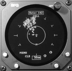
The other side of the weather coin is the sferics device. These systems are generally similar in nature, and provide information on the location, density, and intensity of lightning strikes associated with thunderstorms.
While these systems are pretty accurate in determining the direction from which lightning discharges are being detected, unlike radar, the ranging methodology is based on mathematical algorithms that rely on the lightning conforming to known parameters. Thus, the system can be fooled.
Lightning strikes may be plotted at the wrong distance, or show up as long strobes when the system thinks the lightning is coming from sources at a wide range of distances. For these reasons, the distance information from sferics devices is not entirely reliable. In addition, thunderstorms in certain stages may contain dangerous turbulence but not be producing lightning for the sferics device to detect.
The ideal on-board combination would, of course, be radar and sferics. By correlating the data from both – and anyone who can afford both can afford a multifunction display where the data from both can be overlaid – one can make good choices about where not to stick ones beak.
However, while sferics devices are light, have become more accurate and reliable, are reasonably priced, and are fairly easy to install in light singles and twins, radar is generally limited to turbine-powered aircraft and the upper crust of the piston-powered fleet.
The good news is that the new real-time weather datalinks in the cockpit make it possible to get weather information that is both timely and accurate.
When you look at the national or regional composite radar charts, you are looking at a synthesis of all the data from all the radars around the weather. This often provides multiple views of the same lines or cells. As a result, areas that are hidden from one site due to attenuation are visible to other sites, and the resulting composite picture is much more accurate and complete.
When this is combined with lightning data (either from on-board or ground-based sferics systems), a very complete and clear picture of current thunderstorm activity is provided, including the very good real-time capability of the NEXRAD radar sites.
In planning routes through areas of thunderstorm activity, it is generally a given that higher is better. One must temper that statement with an understanding of local thunderstorm phenomena. One major exception is the high base thunderstorm seen in the western United States.
In these very hot, yet very dry areas, the moisture content of the air is so low and the surface temperature so high, that the parcel of air must be lofted to extraordinary heights before it cools enough to condense, and further to freeze, and thus become a thunderstorm.
In such areas, the bases may be 5,000 or 6,000 feet or more above the terrain, and the precipitation often evaporates rapidly below it, leaving only a bit of virga showing below the cloud. If the downburst is not occurring, it is often easy to navigate well underneath these storms while maintaining safe terrain clearance.
But because there is no clear rain shaft sticking down from the bases, one must also look at the ground to see if there is a dust ring welling out, showing the effect of a downburst that should be avoided. In these areas, it is often easy to operate VFR below the bases in the nearly unlimited visibilities, which allows plenty of time to see and avoid dangerous cells.
The other sources of radar data are FSS and ATC. While every FSS operating position has access to weather radar data, the Flight Watch position has the most equipment to support the pilot in need of such data.
The problem is that, when one is operating at high altitudes, the single frequency allocated to Flight Watch can be blocked by other aircraft hundreds of miles away talking to a Flight Watch station you cant even hear.
There are a couple of options. First, you can use one of the more local FSS frequencies and get what you can from the specialist you reach. The other, if youre high enough, is to try one of the discrete regional high altitude flight watch frequencies from the inside back cover of the A/FD.
While these frequencies are supposed to be for aircraft operating in the Flight Levels, they are often usable by aircraft operating much lower if they are within line of sight of one of the remote communication outlet sites as shown on the map in the A/FD.
ATC also has radar, but there are a number of drawbacks, and their capabilities vary greatly depending on whether youre talking to Center or Approach, and the state of the facilitys modernization. Approach control facilities with the newer ASR-9 system can display the standard six levels of precipitation intensity you see on most radar maps. The older ASR-7 and -8 systems have a simplified display with less discrimination.
Keep in mind the controller has the ability to suppress the weather returns, and often does so to reduce scope clutter, so make sure you query the controller on what setting his system is on. Also, the older radars are optimized for seeing hard metal targets, not raindrops, so their ability to reliably determine intensity is not that good.
Center radars are a lot less capable than the ASR-9. They get only two levels – H for heavy, and slashes for less than heavy. The problem for pilots is that centers heavy is only about Level 2, so you dont know if its moderate rain or a Level 6 thunderstorm. As a result, if you deviate for all Hs, you will deviate around a lot of non-hazardous weather, but if you dont, youre rolling the dice unless you have other means to determine that thunderstorms are not there.
Which Way to Go?
There are two caveats to consider when getting weather penetration information from controllers. They often base their recommendations on what worked for airplanes in front of you. This is fine as long as you are at least as big as that plane and the situation has not changed materially.
Unfortunately, a ride that was reported as moderate but tolerable turbulence by a 757 may not be so tolerable to a C-172. Also, thunderstorms are very volatile. What was safely penetrable 15 minutes ago may not work now, and what was impassable half an hour ago may be completely gone now.
