Register

Hook A Right … Twice

Perhaps its a bias from learning to fly in Colorado, but I never think of Pennsylvania as particularly mountainous. Yet mountain-dodging is what jumped to mind looking at the RNAV (GPS) Rwy 12 into Williamsport, PA (KIPT). Approach designers dont toss in a 26-degree turn at the final approach fix for no reason, nor do they allow another 16-degree turn from the final approach course to the runway-unless they have to.

Gemini Sparkle

Key Takeaways:

  • The RNAV (GPS) Rwy 12 into Williamsport, PA (KIPT) demonstrates how complex terrain, specifically a river valley, dictates unusual turns and step-down fixes in instrument approach design.
  • Pilots must actively interpret various chart clues—including river presence, sectional tints, "NA" minimums, lack of VDP, and specific obstacle warnings—to identify and understand underlying terrain challenges.
  • Thoroughly reviewing all chart notes (plan view, profile view) and consulting airport supplements (e.g., takeoff minimums, lighting details) is crucial for uncovering critical information about obstacles, operational restrictions (like night limitations), and procedure nuances.
See a mistake? Contact us.

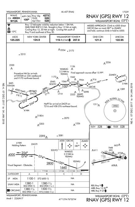
Perhaps it’s a bias from learning to fly in Colorado, but I never think of Pennsylvania as particularly mountainous. Yet mountain-dodging is what jumped to mind looking at the RNAV (GPS) Rwy 12 into Williamsport, PA (KIPT). Approach designers don’t toss in a 26-degree turn at the final approach fix for no reason, nor do they allow another 16-degree turn from the final approach course to the runway—unless they have to.

However, the chart just shows a river and a few towers. What gives?

Ready to Sell Your Aircraft?

List your airplane on AircraftForSale.com and reach qualified buyers.

List Your Aircraft
AircraftForSale Logo | FLYING Logo
Pilot in aircraft
Sign-up for newsletters & special offers!

Get the latest stories & special offers delivered directly to your inbox.

SUBSCRIBE