













Register

The Dreaded Squall Line

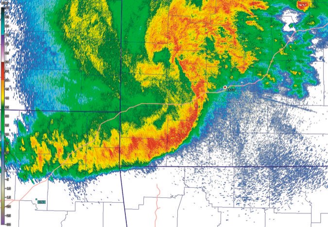
February and March bring the peak season of the squall line. They are perhaps the most formidable of all the mid-latitude weather systems. Most of us at one time or another have witnessed the alarming black mass spanning almost the entire western horizon, followed by the fury of raw wind, small hail, and torrential rains. Indeed these storms were recognized by early Scandinavian fishermen and traders for the sheer amount of rain they produced. In the 17th century the Norwegians gave us the word skval, meaning a sudden rush of water, anglicized to squall by the sailors of Britain.

Gemini Sparkle

Key Takeaways:

  • Squall lines are powerful mid-latitude weather systems, now often referred to as Mesoscale Convective Systems (MCSs), whose understanding evolved significantly through historical observation and modern technology like radar and computer modeling.
  • These systems are characterized by a line of thunderstorms driven by a "gust front" and can produce various severe weather phenomena, including weak tornadoes (quasi-linear convective-system tornadoes), destructive gustnadoes, and severe straight-line windstorms known as derechos.
  • Despite advancements in technology, computer models have limitations in accurately forecasting squall line progression, making human forecasters' expertise and real-time observations from radar and visual cues crucial for accurate predictions and safety.
See a mistake? Contact us.

February and March bring the peak season of the squall line. They are perhaps the most formidable of all the mid-latitude weather systems. Most of us at one time or another have witnessed the alarming black mass spanning almost the entire western horizon, followed by the fury of raw wind, small hail, and torrential rains. Indeed these storms were recognized by early Scandinavian fishermen and traders for the sheer amount of rain they produced. In the 17th century the Norwegians gave us the wordskval, meaning “a sudden rush of water,” anglicized to squall by the sailors of Britain.

Early in the 19th century, a barometer was on every ship and hung in many offices. Squall lines were always suspected whenever the barometer was falling rapidly and the air was sultry. Early meteorologists recognized that it was a clash of air masses that fueled the storm, but the storms were thought to result from chaotic motions indescribable by modern physics. However it was the French meteorologist E. Durand-Greville who pored through weather reports in 1892 and quantified the dimensions. Looking at an August 1890 system that steamrolled through France and Germany, he found the system spanned an impressive 500 miles, showing these were much more than just local storms.


Ready to Sell Your Aircraft?

List your airplane on AircraftForSale.com and reach qualified buyers.

List Your Aircraft
AircraftForSale Logo | FLYING Logo
Pilot in aircraft
Sign-up for newsletters & special offers!

Get the latest stories & special offers delivered directly to your inbox.

SUBSCRIBE