













Register

Remember VORs?

Gemini Sparkle

Key Takeaways:

  • While GPS has become the preferred navigation method due to its simplicity and accuracy, VORs were the original backbone of the National Airspace System.
  • Despite the dominance of GPS, VOR navigation skills are still critical as the FAA's Minimum Operating Network (MON) ensures VORs remain a vital backup system for the national airspace, especially during GPS outages.
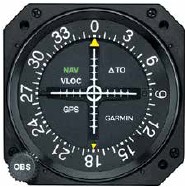
  • VORs provide azimuth information, which pilots interpret using cockpit instruments (Omni Bearing Selector, Course Deviation Indicator, To/From flag) to identify their current radial, intercept specific courses, and navigate airways.
  • Pilots are urged to regularly practice VOR navigation to maintain proficiency, recognizing its indispensable role as the primary backup in case GPS becomes unavailable.
See a mistake? Contact us.

Area navigation using GPS has been around (for us) for about 30 years. Before that we did mostly the same thing using LORAN for a while. But, the National Airspace System was designed around VHF Omni- Range navigation stations, VORs, that long preceded GPS.

Technically, there are three types: VORs that just provide azimuth information, VOR-DMEs that include a DME station, and VORTACs (VOR plus the military tactical air navigation system) that, for our purposes, are the same as VOR-DMEs. Regardless of the type, though, the actual navigation is via azimuth information using the VOR.


Ready to Sell Your Aircraft?

List your airplane on AircraftForSale.com and reach qualified buyers.

List Your Aircraft
AircraftForSale Logo | FLYING Logo
Pilot in aircraft
Sign-up for newsletters & special offers!

Get the latest stories & special offers delivered directly to your inbox.

SUBSCRIBE