Reconnecting with Cotton-Candy Sunrises
After a long hiatus, a cross-country trip reawakens a pilot’s skills, flight planning techniques, and her love of flight.

Amy Laboda got to see a sunrise from her airplane recently for the first time in a long time. [Courtesy: Amy Laboda]
Five a.m. and my eyes are open. I tap the screen of my phone, strategically poised on my nightstand and ready to wake me in 15 minutes.
I don’t need its alarm. I know today is the day I have planned to actually go somewhere in my airplane.
Preparations
I fueled, preflighted and loaded the RV-10 last night before sunset, making sure I tucked a couple of extra quarts of oil, the toolkit and a spare part or two (ever try to get an alternator in rural Idaho?) in with the two gallons of water, sleeping bags, backpacking tent and first-aid/emergency kit. Everything has its place, ensuring proper weight and balance, all cargo secured, so no jostling in turbulence. Our softsided duffles seem diminutive compared to the “insurance” equipment we carry on a long cross country. We can always wash clothes.
Last night before my head hit my pillow I’d updated all my flight planning software, even the backup on my phone, and left the tablet on its charger. A software developer once told me he flew with three tablets at the ready, and I took that advice to heart. I’ve seen an iPad overheat and shut itself down at a most inconvenient moment. Even with the ability to program my routes and IFR approaches into my EFIS, I still carry backup devices.
More than 40 years of flying has taught me: avionics break in flight.
Just before I drifted off to sleep, I contemplated our route: a roughly diagonal slash across the heartland, and hopefully around the highest terrain in the lower 48. I’ve been watching the weather for a week now, even studying detailed lifted index charts that glider pilots and meteorologists cherish; the first looking for free rides aloft, the second attempting to predict tomorrow’s riskiest air masses. It isn’t a straight line.
Using the best information sites we can find (from Windy to AOPA to AirNav to Fltplan.com; there are dozens) we look for inexpensive fuel, the availability of crew cars or airport restaurants, hotels nearby and, because our airplane prefers it, paved runways of appropriate length. As the ground elevations climb, we need longer runways. We narrowed the route down to three possible airports per fuel stop because weather and winds aloft are never as predictable as we think. Quick phone calls earlier in the day confirmed working fuel pumps. Still no guarantee, but it is worth the phone call.
I closed my eyes, knowing we won’t make the entire 2,500 miles tomorrow. That’s a brutally long day in a single-engine airplane, even one that tractors along at 170 knots. But I thought, we’re ready for whatever the day holds. And now it is go-time. I’m dressed and a soft-side cooler filled with cold water, protein and pre-cut fruit is ready to tuck where the co-pilot can reach it. Sunglasses and phone (in airplane mode) goes in the pocket by the pilot’s knee.
Go Time, Finally
The airplane is out, the ramp flood lights click off and my headlamp clicks on. I run the checklists and the trusty Titan engine turns over on the second blade. The EFIS pass their self-checks. All good signs, I think.
It’s been a long haul getting here. The global pandemic that caught much of the U.S. by surprise in March 2020 was on my radar two months earlier than many people because we had family living in Asia near the epicenter. They brought a deep understanding of risk home with them (and because of their caution, no illness). They also brought hope, in the form of new life gestating. After months in protection mode it looks like the U.S. is coming out on top of this fight and the world around us feels safer for travel. Our new family member is a tough little guy and his parents are heading cautiously back out on their own.
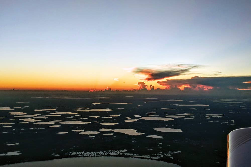
“I missed these dark morning departures that bless us with technicolor cotton-candy ribbons of pink and orange, sunlight painting swathes of high cirrus and brilliant rings of gold and silhouetting cumulonimbus over the Atlantic as we climbed across Central Florida’s lake district.”
And we, the two pilots (and only mechanic) in the family are ready to take a long cross-country flight in our airplane.
I admit that this hiatus has been painful. No, we didn’t let our flying skills atrophy—it wasn’t tough at all for one pilot or the other (or both of us) to get the hyper-efficient RV-10 up for an hour every week or so.
But these hops were short and eventually, a little too predictable. The only variability I seemed to be able to drum up was flying a patchwork of random flights on my computer with X-Plane’s flight simulation.
Stimulating and good for my IFR skills, but so not emotionally fulfilling. Long cross countries used to be our signature and I missed the wonder of it, the margin of unpredictability that comes from looking out 2,500 miles. I missed these dark morning departures that bless us with technicolor cotton-candy ribbons of pink and orange, sunlight painting swathes of high cirrus and brilliant rings of gold and silhouetting cumulonimbus over the Atlantic as we climbed across Central Florida’s lake district. The air is cool above 8,000 msl, and it always feels good to have a day of flying ahead of me.
Run up complete, we launch, rotating carefully to compensate for the difference in “feel” with a fully loaded bird. One turn and I’m on course, climbing at a leisurely pace in the clear morning air. My goal is 10,500 MSL, but there is no rush; the highest elevation on this first leg of my journey is 500 ft.
There is the perpetual technical issue of crossing the first “rumble strip;” a demarcation line of sorts where summer cold fronts come to die. It is either sitting diagonal along Florida’s northern border or sunk deep into the Ohio River valley, but it is always floating there, and there is always a line, sometimes more solid than others, of showers and thunderstorms that persist through the night. Crossing in the wee hours of the morning is often the moment when the storms have the least energy. Using Nexrad and a little guidance from a lonely center ATC we can nearly always pick a path through.
By the first fuel stop, roughly three and a half hours later, we’ve hit our groove. The muggy morning air and leftover wisps of fog tell me it is good we left early. There will be rain here later. Before the day is out we’ll have crossed the Mississippi, crossed Oklahoma and soared into Colorado, if the wind and weather let us. Big sky country. Snow-kissed mountains in sight. I point the nose of the airplane northwest and climb.

Subscribe to Our Newsletter
Get the latest FLYING stories delivered directly to your inbox

